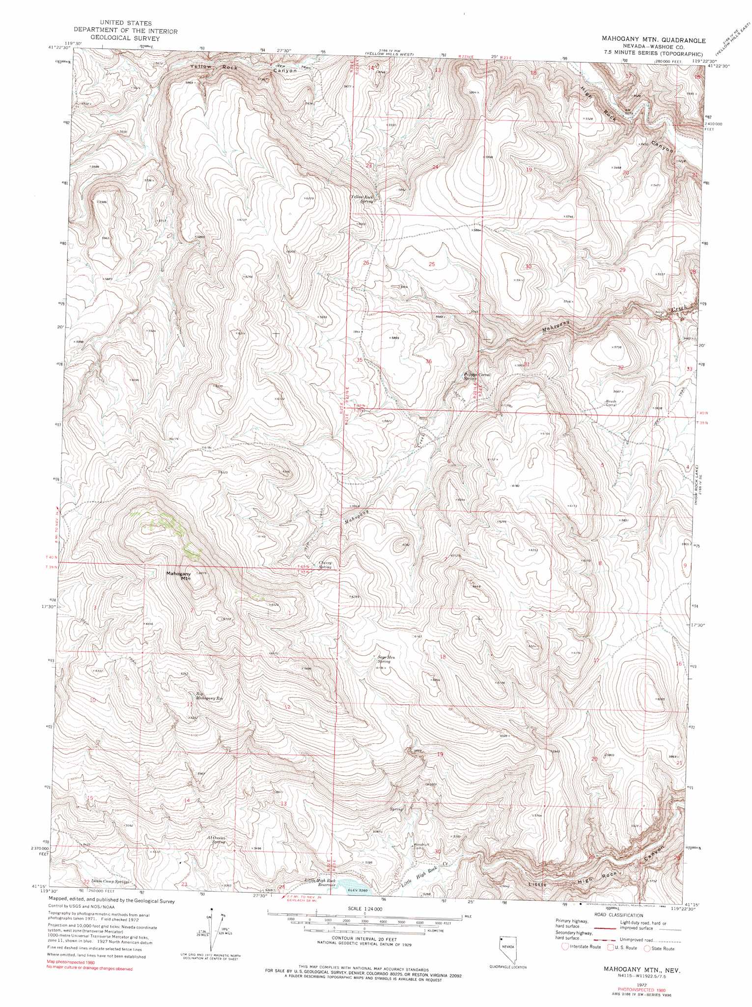
Mahogany Mountain Topo Map Nevada
To zoom in, hover over the map of Mahogany Mountain
USGS Topo Quad 41119c4 - 1:24,000 scale
| Topo Map Name: | Mahogany Mountain |
| USGS Topo Quad ID: | 41119c4 |
| Print Size: | ca. 21 1/4" wide x 27" high |
| Southeast Coordinates: | 41.25° N latitude / 119.375° W longitude |
| Map Center Coordinates: | 41.3125° N latitude / 119.4375° W longitude |
| U.S. State: | NV |
| Filename: | o41119c4.jpg |
| Download Map JPG Image: | Mahogany Mountain topo map 1:24,000 scale |
| Map Type: | Topographic |
| Topo Series: | 7.5´ |
| Map Scale: | 1:24,000 |
| Source of Map Images: | United States Geological Survey (USGS) |
| Alternate Map Versions: |
Mahogany Mtn NV 1972, updated 1976 Download PDF Buy paper map Mahogany Mtn NV 1972, updated 1990 Download PDF Buy paper map Mahogany Mountain NV 2011 Download PDF Buy paper map Mahogany Mountain NV 2015 Download PDF Buy paper map |
1:24,000 Topo Quads surrounding Mahogany Mountain
Painted Point |
Massacre Creek |
Nut Mountain |
Badger Mountain Se |
Bear Buttes |
Powers Well |
Nellie Spring Mountain |
Yellow Hills West |
Yellow Hills East |
Soldier Meadow |
Pinto Springs |
Hart Mountain |
Mahogany Mountain |
High Rock Lake |
Mud Meadow |
Bordwell Spring |
Chester Lyons Spring |
Butte Spring |
Mcconnel Canyon |
Wagner Springs |
Lost Creek Pass |
Fox Mountain |
Leadville |
Division Peak |
Donnelly Creek |
> Back to 41119a1 at 1:100,000 scale
> Back to 41118a1 at 1:250,000 scale
> Back to U.S. Topo Maps home
Mahogany Mountain topo map: Gazetteer
Mahogany Mountain: Ranges
Little High Rock Mountains elevation 2079m 6820′Mahogany Mountain: Reservoirs
Big Mahogany Reservoir elevation 1891m 6204′Mahogany Mountain: Springs
Al Owens Spring elevation 1662m 5452′Cherry Spring elevation 1854m 6082′
Denio Camp Springs elevation 1634m 5360′
Pappys Corral Spring elevation 1692m 5551′
Sage Hen Spring elevation 1853m 6079′
Yellow Rock Spring elevation 1773m 5816′
Mahogany Mountain: Streams
Hog Ranch Creek elevation 1605m 5265′Mahogany Mountain: Summits
Mahogany Mountain elevation 2125m 6971′Mahogany Mountain digital topo map on disk
Buy this Mahogany Mountain topo map showing relief, roads, GPS coordinates and other geographical features, as a high-resolution digital map file on DVD: