Mcconnel Canyon Topo Map Nevada
To zoom in, hover over the map of Mcconnel Canyon
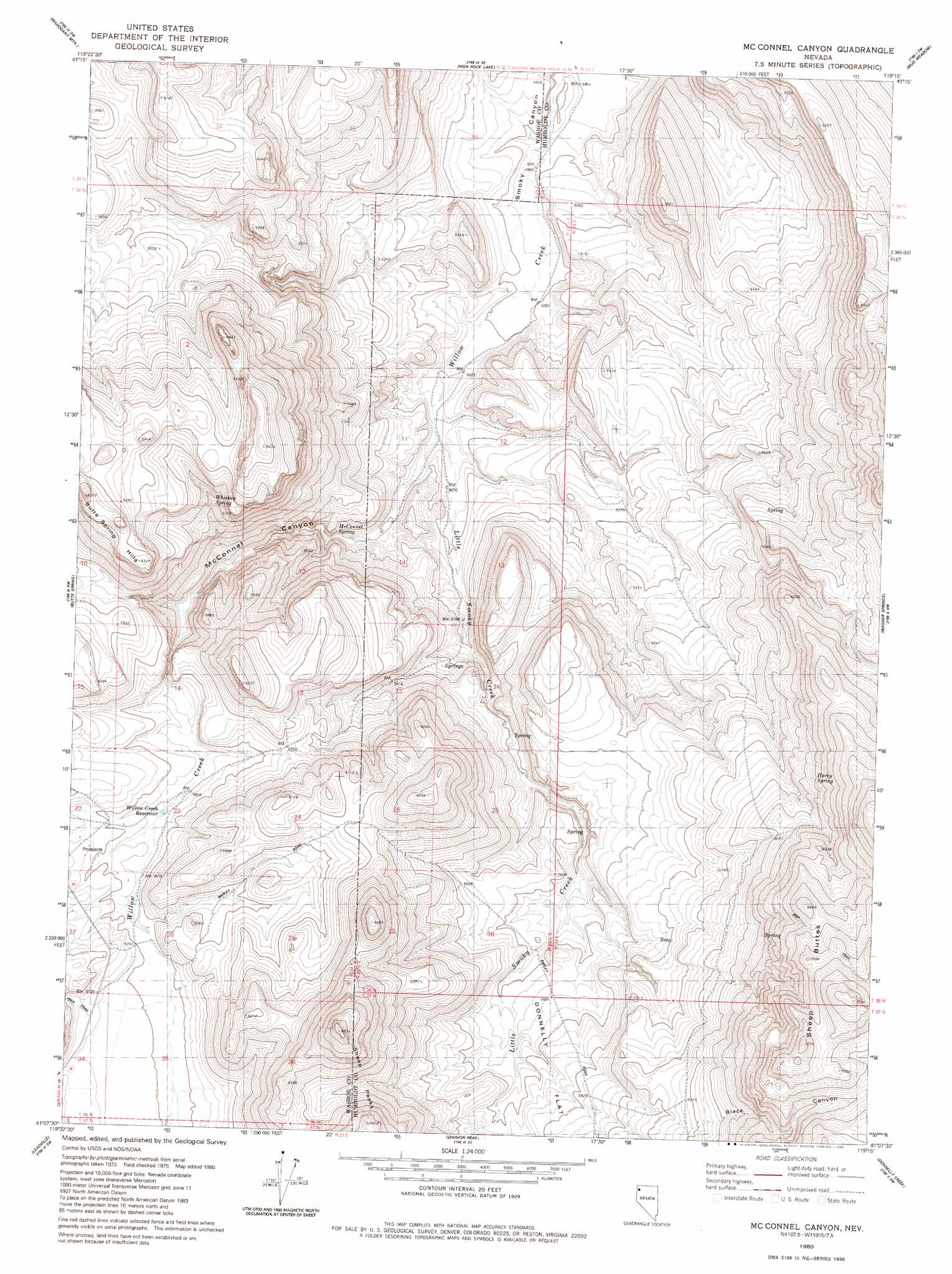
USGS Topo Quad 41119b3 - 1:24,000 scale
| Topo Map Name: | Mcconnel Canyon |
| USGS Topo Quad ID: | 41119b3 |
| Print Size: | ca. 21 1/4" wide x 27" high |
| Southeast Coordinates: | 41.125° N latitude / 119.25° W longitude |
| Map Center Coordinates: | 41.1875° N latitude / 119.3125° W longitude |
| U.S. State: | NV |
| Filename: | o41119b3.jpg |
| Download Map JPG Image: | Mcconnel Canyon topo map 1:24,000 scale |
| Map Type: | Topographic |
| Topo Series: | 7.5´ |
| Map Scale: | 1:24,000 |
| Source of Map Images: | United States Geological Survey (USGS) |
| Alternate Map Versions: |
Mc Connel Canyon NV 1980, updated 1980 Download PDF Buy paper map McConnel Canyon NV 2011 Download PDF Buy paper map McConnel Canyon NV 2015 Download PDF Buy paper map |
1:24,000 Topo Quads surrounding Mcconnel Canyon
Nellie Spring Mountain |
Yellow Hills West |
Yellow Hills East |
Soldier Meadow |
Red Mountain |
Hart Mountain |
Mahogany Mountain |
High Rock Lake |
Mud Meadow |
Big Mountain |
Chester Lyons Spring |
Butte Spring |
Mcconnel Canyon |
Wagner Springs |
Clapper Creek |
Fox Mountain |
Leadville |
Division Peak |
Donnelly Creek |
Double Hot Springs |
Crutcher Canyon |
Melody Mountain |
Hualapai Flat North |
Mormon Dan Peak |
Black Rock Point West |
> Back to 41119a1 at 1:100,000 scale
> Back to 41118a1 at 1:250,000 scale
> Back to U.S. Topo Maps home
Mcconnel Canyon topo map: Gazetteer
Mcconnel Canyon: Reservoirs
Willow Creek Reservoir elevation 1727m 5666′Mcconnel Canyon: Springs
Flower Spring elevation 1615m 5298′Harry Spring elevation 1878m 6161′
McConnel Spring elevation 1565m 5134′
Whiskey Spring elevation 1774m 5820′
Mcconnel Canyon: Streams
Little Smoky Creek elevation 1564m 5131′Mcconnel Canyon: Summits
Sheep Buttes elevation 2233m 7326′Mcconnel Canyon: Valleys
Black Canyon elevation 1878m 6161′McConnel Canyon elevation 1537m 5042′
Mcconnel Canyon digital topo map on disk
Buy this Mcconnel Canyon topo map showing relief, roads, GPS coordinates and other geographical features, as a high-resolution digital map file on DVD: