Ypsilanti East Topo Map Michigan
To zoom in, hover over the map of Ypsilanti East
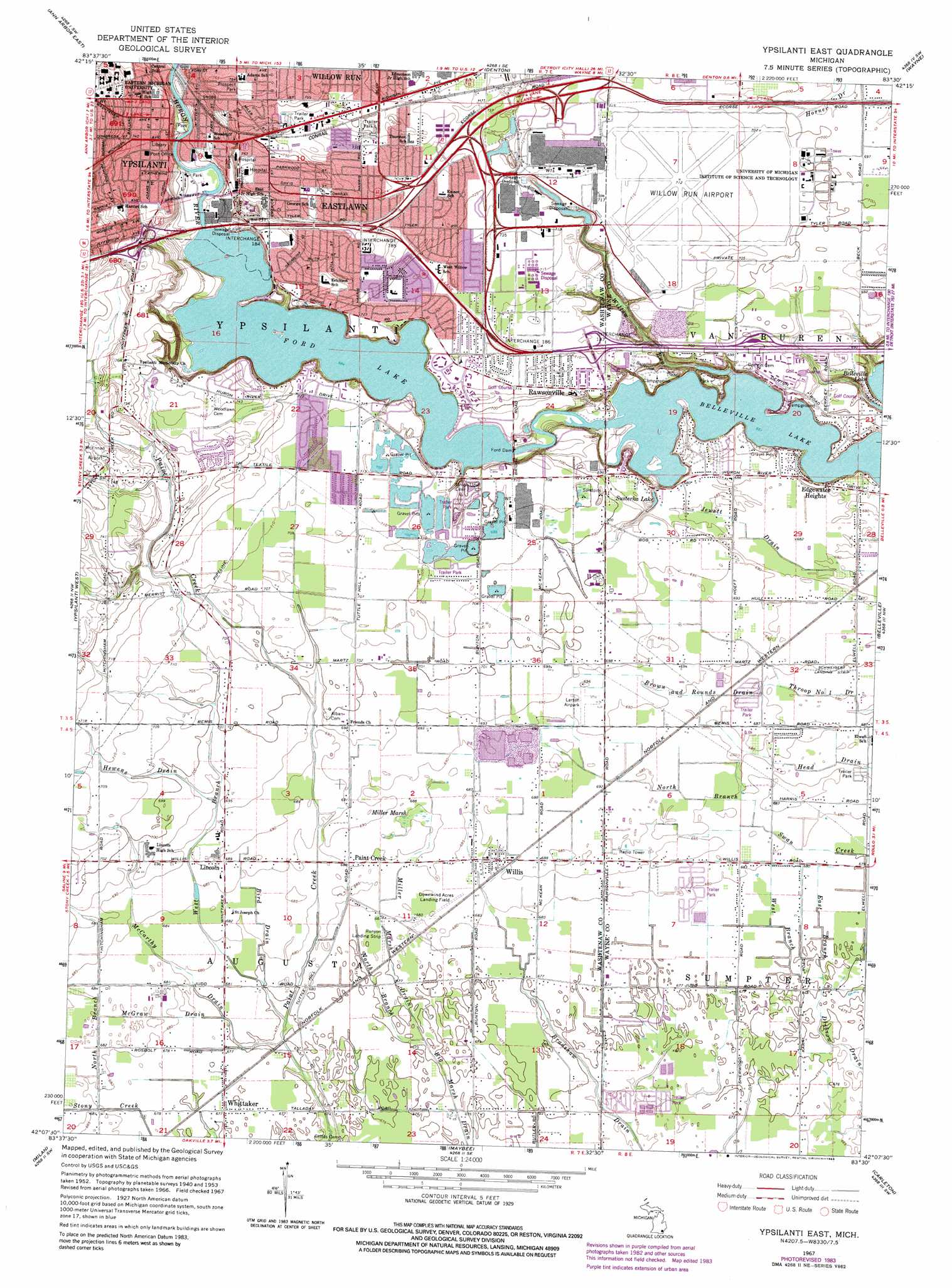
USGS Topo Quad 42083b5 - 1:24,000 scale
| Topo Map Name: | Ypsilanti East |
| USGS Topo Quad ID: | 42083b5 |
| Print Size: | ca. 21 1/4" wide x 27" high |
| Southeast Coordinates: | 42.125° N latitude / 83.5° W longitude |
| Map Center Coordinates: | 42.1875° N latitude / 83.5625° W longitude |
| U.S. State: | MI |
| Filename: | o42083b5.jpg |
| Download Map JPG Image: | Ypsilanti East topo map 1:24,000 scale |
| Map Type: | Topographic |
| Topo Series: | 7.5´ |
| Map Scale: | 1:24,000 |
| Source of Map Images: | United States Geological Survey (USGS) |
| Alternate Map Versions: |
Ypsilanti East MI 1942 Download PDF Buy paper map Ypsilanti East MI 1953, updated 1955 Download PDF Buy paper map Ypsilanti East MI 1967, updated 1974 Download PDF Buy paper map Ypsilanti East MI 1967, updated 1984 Download PDF Buy paper map Ypsilanti East MI 1967, updated 1989 Download PDF Buy paper map Ypsilanti East MI 1996, updated 2000 Download PDF Buy paper map Ypsilanti East MI 2011 Download PDF Buy paper map Ypsilanti East MI 2014 Download PDF Buy paper map Ypsilanti East MI 2017 Download PDF Buy paper map |
1:24,000 Topo Quads surrounding Ypsilanti East
Hamburg |
South Lyon |
Salem |
Northville |
Redford |
Ann Arbor West |
Ann Arbor East |
Denton |
Wayne |
Inkster |
Saline |
Ypsilanti West |
Ypsilanti East |
Belleville |
Flat Rock Ne |
Macon |
Milan |
Maybee |
Carleton |
Flat Rock |
Deerfield |
Dundee |
Ida |
Monroe |
Stony Point |
> Back to 42083a1 at 1:100,000 scale
> Back to 42082a1 at 1:250,000 scale
> Back to U.S. Topo Maps home
Ypsilanti East topo map: Gazetteer
Ypsilanti East: Airports
Downwind Acres Airport elevation 208m 682′Larsen Air Park elevation 211m 692′
Willow Run Airport elevation 217m 711′
Ypsilanti East: Canals
Bird Drain elevation 207m 679′Brown and Rounds Drain elevation 210m 688′
East Branch elevation 206m 675′
Jewett Drain elevation 207m 679′
McGraw Drain elevation 207m 679′
North Branch elevation 207m 679′
West Branch elevation 206m 675′
Ypsilanti East: Crossings
Interchange 184 elevation 220m 721′Interchange 185 elevation 223m 731′
Interchange 186 elevation 219m 718′
Interchange 187 elevation 218m 715′
Ypsilanti East: Dams
Ford Dam elevation 207m 679′Ypsilanti East: Lakes
Susterka Lake elevation 206m 675′Ypsilanti East: Parks
Belleville Pointe Park elevation 210m 688′Prospect Park elevation 232m 761′
Ypsilanti East: Populated Places
Eastlawn elevation 227m 744′Edgewater Heights elevation 205m 672′
Lincoln elevation 210m 688′
Paint Creek elevation 209m 685′
Rawsonville elevation 217m 711′
Whittaker elevation 207m 679′
Willis elevation 209m 685′
Ypsilanti elevation 220m 721′
Ypsilanti East: Reservoirs
Ford Lake elevation 206m 675′Ypsilanti East: Streams
Hewens Drain elevation 210m 688′McCarthy Drain elevation 205m 672′
Miller Marsh Drain elevation 204m 669′
North Branch Big Marsh Drain elevation 204m 669′
West Branch Paint Creek elevation 204m 669′
Willow Run elevation 200m 656′
Ypsilanti East: Swamps
Miller Marsh elevation 208m 682′Ypsilanti East digital topo map on disk
Buy this Ypsilanti East topo map showing relief, roads, GPS coordinates and other geographical features, as a high-resolution digital map file on DVD:
 map DVD")