Dundee Topo Map Michigan
To zoom in, hover over the map of Dundee
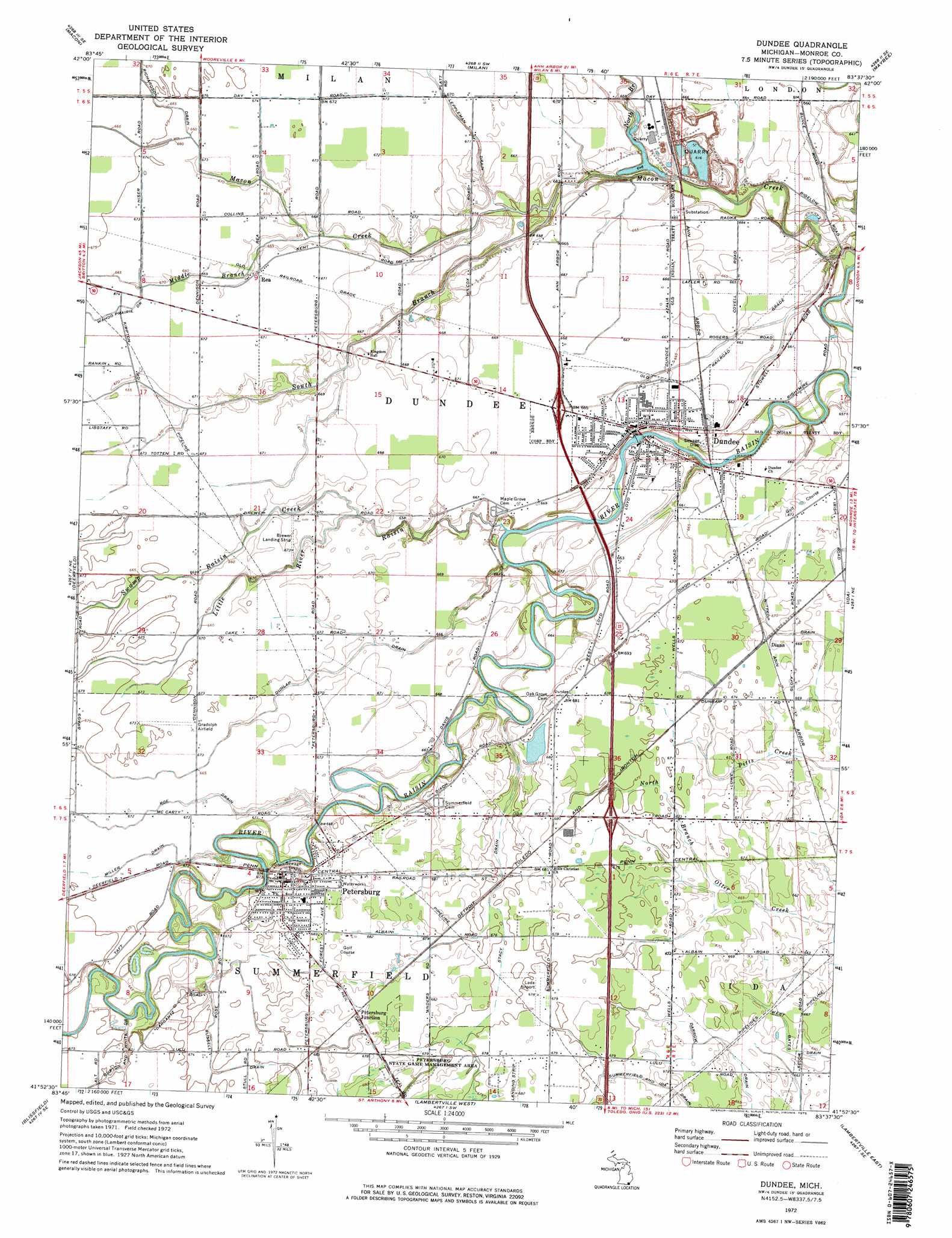
USGS Topo Quad 41083h6 - 1:24,000 scale
| Topo Map Name: | Dundee |
| USGS Topo Quad ID: | 41083h6 |
| Print Size: | ca. 21 1/4" wide x 27" high |
| Southeast Coordinates: | 41.875° N latitude / 83.625° W longitude |
| Map Center Coordinates: | 41.9375° N latitude / 83.6875° W longitude |
| U.S. State: | MI |
| Filename: | o41083h6.jpg |
| Download Map JPG Image: | Dundee topo map 1:24,000 scale |
| Map Type: | Topographic |
| Topo Series: | 7.5´ |
| Map Scale: | 1:24,000 |
| Source of Map Images: | United States Geological Survey (USGS) |
| Alternate Map Versions: |
Dundee MI 1972, updated 1975 Download PDF Buy paper map Dundee MI 1972, updated 1975 Download PDF Buy paper map Dundee MI 2011 Download PDF Buy paper map Dundee MI 2014 Download PDF Buy paper map Dundee MI 2016 Download PDF Buy paper map |
1:24,000 Topo Quads surrounding Dundee
Bridgewater |
Saline |
Ypsilanti West |
Ypsilanti East |
Belleville |
Tecumseh North |
Macon |
Milan |
Maybee |
Carleton |
Tecumseh South |
Deerfield |
Dundee |
Ida |
Monroe |
Palmyra |
Blissfield |
Lambertville West |
Lambertville East |
Erie |
Assumption |
Berkey |
Sylvania |
Toledo |
Oregon |
> Back to 41083e1 at 1:100,000 scale
> Back to 41082a1 at 1:250,000 scale
> Back to U.S. Topo Maps home
Dundee topo map: Gazetteer
Dundee: Airports
Gradolph Field elevation 205m 672′Lada Airport elevation 205m 672′
Dundee: Crossings
Interchange 13 elevation 208m 682′Interchange 15 elevation 203m 666′
Interchange 17 elevation 205m 672′
Dundee: Parks
Dundee Reggies Park elevation 204m 669′Petersburg State Game Management Area elevation 207m 679′
Saint John Evangelical Lutheran Church Historical Marker elevation 203m 666′
West County Park elevation 196m 643′
Dundee: Populated Places
Country Heritage Mobile Home Park elevation 201m 659′Diann elevation 204m 669′
Dundee elevation 203m 666′
Dundee Meadows Mobile Home Park elevation 202m 662′
Petersburg elevation 206m 675′
Petersburg Junction elevation 208m 682′
Rea elevation 204m 669′
Dundee: Post Offices
Dundee Post Office elevation 197m 646′Petersburg Post Office elevation 206m 675′
Rea Post Office (historical) elevation 204m 669′
Dundee: Streams
Burton and White Drain elevation 200m 656′Dunlap Drain elevation 200m 656′
Leppleman Drain elevation 198m 649′
Little River Raisin elevation 197m 646′
Middle Branch Macon Creek elevation 201m 659′
Miller Drain elevation 199m 652′
North Branch Macon Creek elevation 197m 646′
Richardson Drain elevation 203m 666′
Roe Drain elevation 199m 652′
Russell Drain elevation 200m 656′
South Branch Macon Creek elevation 198m 649′
Stacy Drain elevation 198m 649′
Swamp Raisin Creek elevation 201m 659′
Wahoo Prairie Drain elevation 203m 666′
Dundee digital topo map on disk
Buy this Dundee topo map showing relief, roads, GPS coordinates and other geographical features, as a high-resolution digital map file on DVD:
 map DVD")