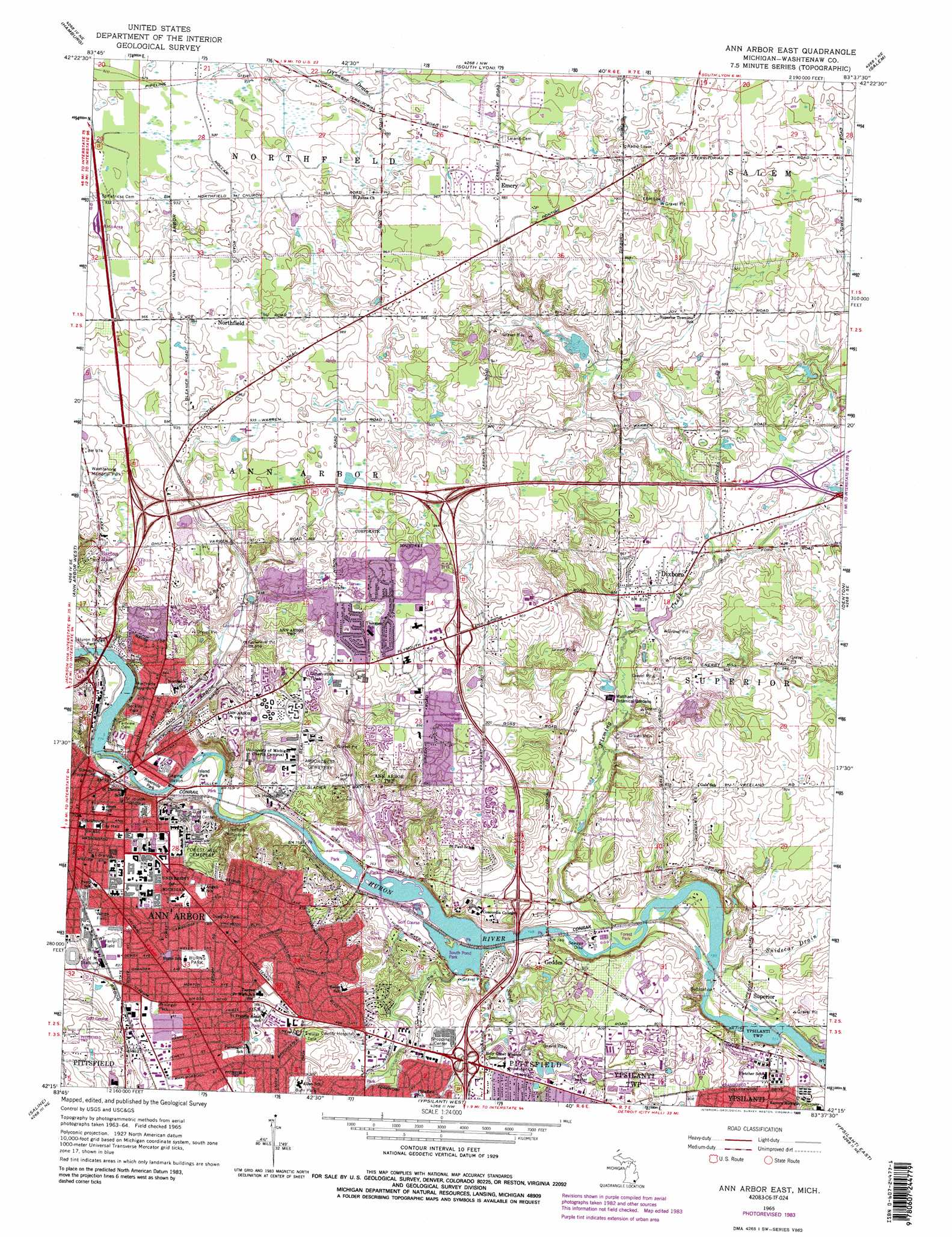
Ann Arbor East Topo Map Michigan
To zoom in, hover over the map of Ann Arbor East
USGS Topo Quad 42083c6 - 1:24,000 scale
| Topo Map Name: | Ann Arbor East |
| USGS Topo Quad ID: | 42083c6 |
| Print Size: | ca. 21 1/4" wide x 27" high |
| Southeast Coordinates: | 42.25° N latitude / 83.625° W longitude |
| Map Center Coordinates: | 42.3125° N latitude / 83.6875° W longitude |
| U.S. State: | MI |
| Filename: | o42083c6.jpg |
| Download Map JPG Image: | Ann Arbor East topo map 1:24,000 scale |
| Map Type: | Topographic |
| Topo Series: | 7.5´ |
| Map Scale: | 1:24,000 |
| Source of Map Images: | United States Geological Survey (USGS) |
| Alternate Map Versions: |
Ann Arbor East MI 1965, updated 1967 Download PDF Buy paper map Ann Arbor East MI 1965, updated 1974 Download PDF Buy paper map Ann Arbor East MI 1965, updated 1978 Download PDF Buy paper map Ann Arbor East MI 1965, updated 1980 Download PDF Buy paper map Ann Arbor East MI 1965, updated 1984 Download PDF Buy paper map Ann Arbor East MI 1965, updated 1989 Download PDF Buy paper map Ann Arbor East MI 1965, updated 1989 Download PDF Buy paper map Ann Arbor East MI 2011 Download PDF Buy paper map Ann Arbor East MI 2014 Download PDF Buy paper map Ann Arbor East MI 2017 Download PDF Buy paper map |
1:24,000 Topo Quads surrounding Ann Arbor East
Howell |
Brighton |
Kent Lake |
Milford |
Walled Lake |
Pinckney |
Hamburg |
South Lyon |
Salem |
Northville |
Dexter |
Ann Arbor West |
Ann Arbor East |
Denton |
Wayne |
Bridgewater |
Saline |
Ypsilanti West |
Ypsilanti East |
Belleville |
Tecumseh North |
Macon |
Milan |
Maybee |
Carleton |
> Back to 42083a1 at 1:100,000 scale
> Back to 42082a1 at 1:250,000 scale
> Back to U.S. Topo Maps home
Ann Arbor East topo map: Gazetteer
Ann Arbor East: Airports
CMHS Heliport elevation 253m 830′Overflow Pad elevation 235m 770′
Survival Flight Heliport elevation 257m 843′
UMMC Heliport elevation 235m 770′
Ann Arbor East: Canals
Chalmers Drain elevation 233m 764′Ann Arbor East: Parks
Beckley Park elevation 257m 843′Burns Park elevation 262m 859′
Douglas Park elevation 268m 879′
Ferry Field elevation 253m 830′
Frisinger Park elevation 252m 826′
Gallup Lake Park elevation 228m 748′
Huron Bridge Park elevation 239m 784′
Island Park elevation 234m 767′
Nichols Arboretum elevation 243m 797′
Northside Playground elevation 257m 843′
Summit Playground elevation 238m 780′
University of Michigan Stadium elevation 269m 882′
Wines Field elevation 251m 823′
Ann Arbor East: Populated Places
Ann Arbor elevation 268m 879′Dixboro elevation 249m 816′
Emery elevation 301m 987′
Geddes elevation 250m 820′
Northfield elevation 296m 971′
Superior elevation 226m 741′
Ann Arbor East: Streams
Fleming Creek elevation 224m 734′Snidecar Drain elevation 225m 738′
Swift Drain elevation 228m 748′
Ann Arbor East digital topo map on disk
Buy this Ann Arbor East topo map showing relief, roads, GPS coordinates and other geographical features, as a high-resolution digital map file on DVD:
 map DVD")