Scotch Grove Topo Map Iowa
To zoom in, hover over the map of Scotch Grove
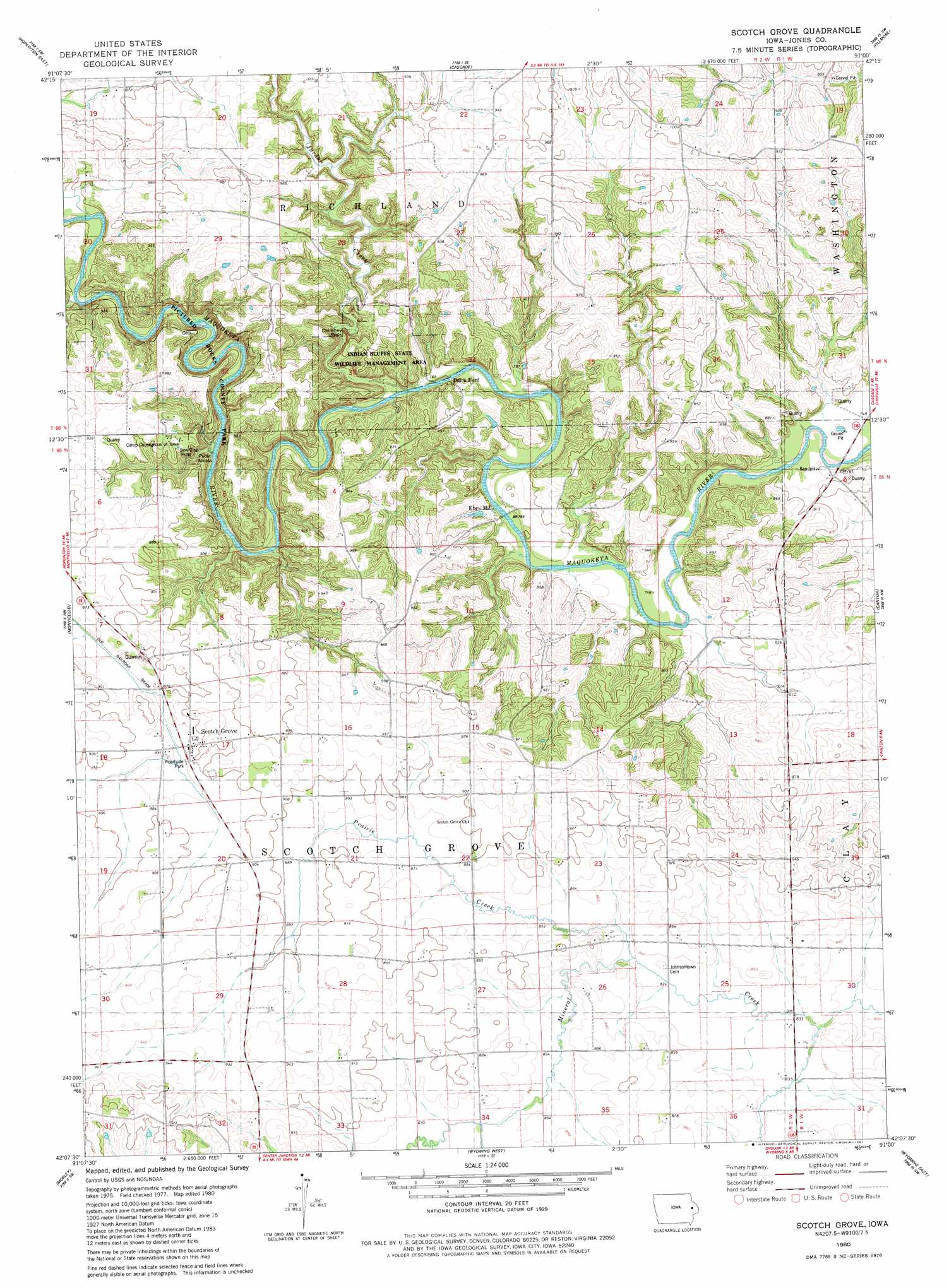
USGS Topo Quad 42091b1 - 1:24,000 scale
| Topo Map Name: | Scotch Grove |
| USGS Topo Quad ID: | 42091b1 |
| Print Size: | ca. 21 1/4" wide x 27" high |
| Southeast Coordinates: | 42.125° N latitude / 91° W longitude |
| Map Center Coordinates: | 42.1875° N latitude / 91.0625° W longitude |
| U.S. State: | IA |
| Filename: | o42091b1.jpg |
| Download Map JPG Image: | Scotch Grove topo map 1:24,000 scale |
| Map Type: | Topographic |
| Topo Series: | 7.5´ |
| Map Scale: | 1:24,000 |
| Source of Map Images: | United States Geological Survey (USGS) |
| Alternate Map Versions: |
Scotch Grove IA 1980, updated 1981 Download PDF Buy paper map Scotch Grove IA 2010 Download PDF Buy paper map Scotch Grove IA 2013 Download PDF Buy paper map Scotch Grove IA 2015 Download PDF Buy paper map |
1:24,000 Topo Quads surrounding Scotch Grove
Earlville |
Dyersville West |
Dyersville East |
Epworth |
Peosta |
Hopkinton West |
Hopkinton East |
Cascade |
Fillmore |
Bernard |
Anamosa Ne |
Monticello |
Scotch Grove |
Canton |
Leisure Lake |
Anamosa |
Morley |
Wyoming West |
Wyoming East |
Baldwin |
Mechanicsville |
Stanwood |
Clarence |
Oxford Junction |
Lost Nation |
> Back to 42091a1 at 1:100,000 scale
> Back to 42090a1 at 1:250,000 scale
> Back to U.S. Topo Maps home
Scotch Grove topo map: Gazetteer
Scotch Grove: Areas
Indian Bluffs State Wildlife Management Area elevation 262m 859′Scotch Grove: Bridges
Corbett's Mill Bridge elevation 267m 875′Scotch Grove: Parks
Chimney Rock Indian Bluffs State Game Mgt Ar elevation 277m 908′Pictured Rocks County Park elevation 269m 882′
Scotch Grove: Populated Places
Dales Ford elevation 233m 764′Ebys Mill elevation 231m 757′
Johnson (historical) elevation 262m 859′
Scotch Grove elevation 267m 875′
Springhole elevation 232m 761′
Scotch Grove: Post Offices
Fuller's Mills Post Office (historical) elevation 250m 820′Johnson Post Office (historical) elevation 262m 859′
Scotch Grove Post Office (historical) elevation 267m 875′
Scotch Grove: Streams
Jurdan Creek elevation 237m 777′Prairie Creek elevation 256m 839′
Tibbetts Creek elevation 238m 780′
Tibetts Creek elevation 237m 777′
Scotch Grove: Summits
Chimney Rock elevation 258m 846′Scotch Grove digital topo map on disk
Buy this Scotch Grove topo map showing relief, roads, GPS coordinates and other geographical features, as a high-resolution digital map file on DVD: