Turkey River Topo Map Iowa
To zoom in, hover over the map of Turkey River
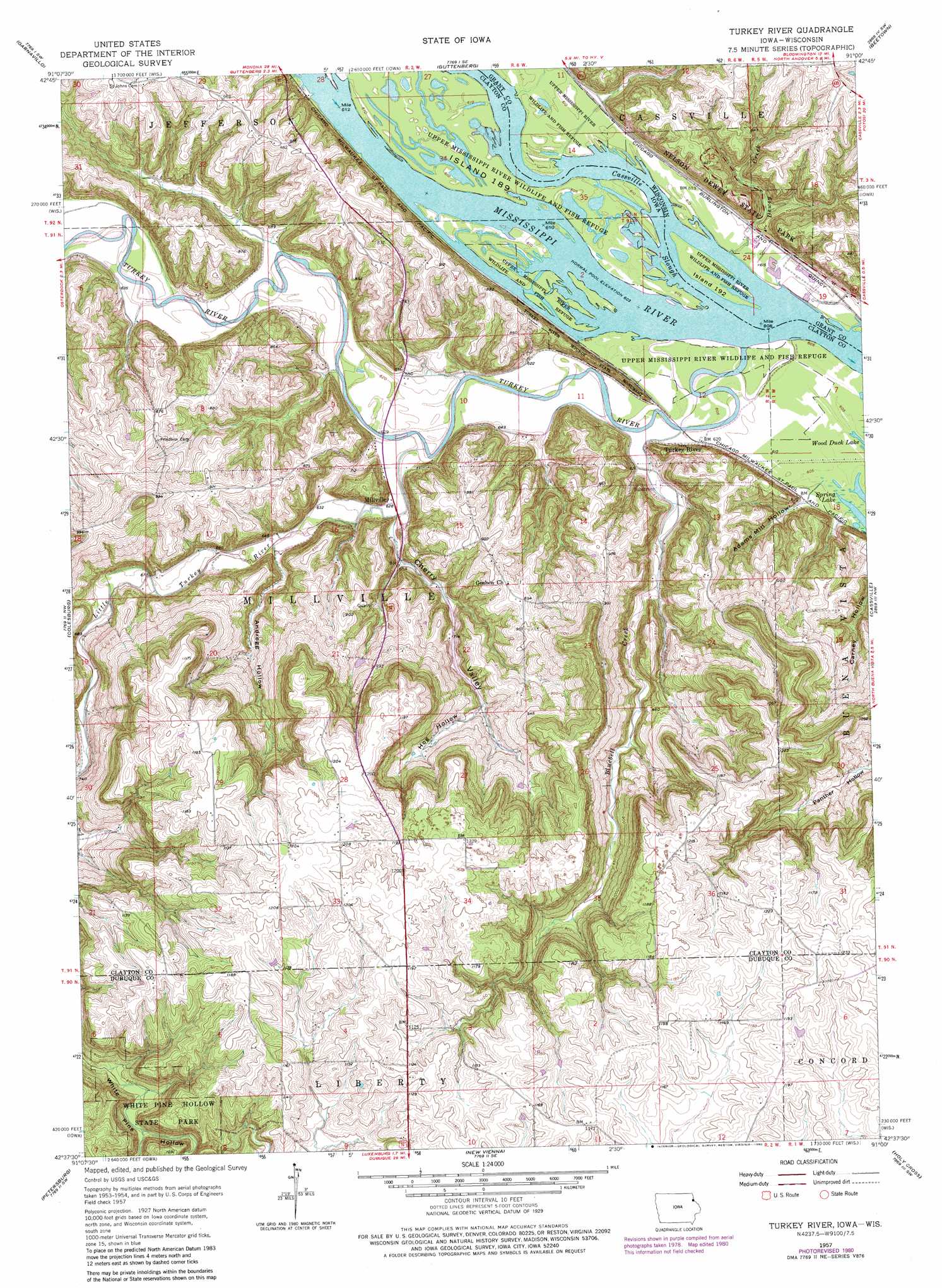
USGS Topo Quad 42091f1 - 1:24,000 scale
| Topo Map Name: | Turkey River |
| USGS Topo Quad ID: | 42091f1 |
| Print Size: | ca. 21 1/4" wide x 27" high |
| Southeast Coordinates: | 42.625° N latitude / 91° W longitude |
| Map Center Coordinates: | 42.6875° N latitude / 91.0625° W longitude |
| U.S. States: | IA, WI |
| Filename: | o42091f1.jpg |
| Download Map JPG Image: | Turkey River topo map 1:24,000 scale |
| Map Type: | Topographic |
| Topo Series: | 7.5´ |
| Map Scale: | 1:24,000 |
| Source of Map Images: | United States Geological Survey (USGS) |
| Alternate Map Versions: |
Turkey River IA 1957, updated 1959 Download PDF Buy paper map Turkey River IA 1957, updated 1968 Download PDF Buy paper map Turkey River IA 1957, updated 1980 Download PDF Buy paper map Turkey River IA 2010 Download PDF Buy paper map Turkey River IA 2013 Download PDF Buy paper map Turkey River IA 2015 Download PDF Buy paper map |
1:24,000 Topo Quads surrounding Turkey River
Farmersburg |
Clayton |
Bagley |
Bloomington |
Mount Hope |
Littleport |
Garnavillo |
Guttenberg |
Beetown |
Hurricane |
Garber |
Colesburg |
Turkey River |
Cassville |
Balltown |
Greeley |
Petersburg |
New Vienna |
Holy Cross |
Sherrill |
Earlville |
Dyersville West |
Dyersville East |
Epworth |
Peosta |
> Back to 42091e1 at 1:100,000 scale
> Back to 42090a1 at 1:250,000 scale
> Back to U.S. Topo Maps home
Turkey River topo map: Gazetteer
Turkey River: Channels
Cassville Iowa Slough elevation 186m 610′Turkey River: Islands
Island 189 elevation 186m 610′Island Number One Hundred Ninety-two elevation 186m 610′
Turkey River: Lakes
Spring Lake elevation 186m 610′Turkey River: Parks
Dewey Heights Prairie State Natural Area elevation 247m 810′Merritt Forest State Preserve elevation 236m 774′
Nelson Dewey State Park elevation 263m 862′
Peter Holms Historical Marker elevation 269m 882′
Turkey River Mounds State Monument elevation 250m 820′
Turkey River Mounds State Preserve elevation 227m 744′
White Pine Hollow State Park elevation 329m 1079′
Turkey River: Populated Places
Millville elevation 193m 633′Turkey River elevation 206m 675′
Turkey River: Post Offices
Anderson Post Office (historical) elevation 363m 1190′Graham Post Office (historical) elevation 246m 807′
Millville Post Office (historical) elevation 193m 633′
Turkey River Post Office (historical) elevation 206m 675′
Turkey River: Streams
Bluebell Creek elevation 187m 613′Cassville Slough elevation 186m 610′
Dewey Creek elevation 185m 606′
Furnace Branch elevation 186m 610′
Little Turkey River elevation 187m 613′
Muddy Creek elevation 186m 610′
Turkey River elevation 186m 610′
Turkey River: Valleys
Adams Mill Hollow elevation 190m 623′Andregg Hollow elevation 200m 656′
Cherry Valley elevation 191m 626′
Hog Hollow elevation 235m 770′
Point Hollow elevation 264m 866′
Turkey River digital topo map on disk
Buy this Turkey River topo map showing relief, roads, GPS coordinates and other geographical features, as a high-resolution digital map file on DVD: