Horseshoe Lake Topo Map Wyoming
To zoom in, hover over the map of Horseshoe Lake
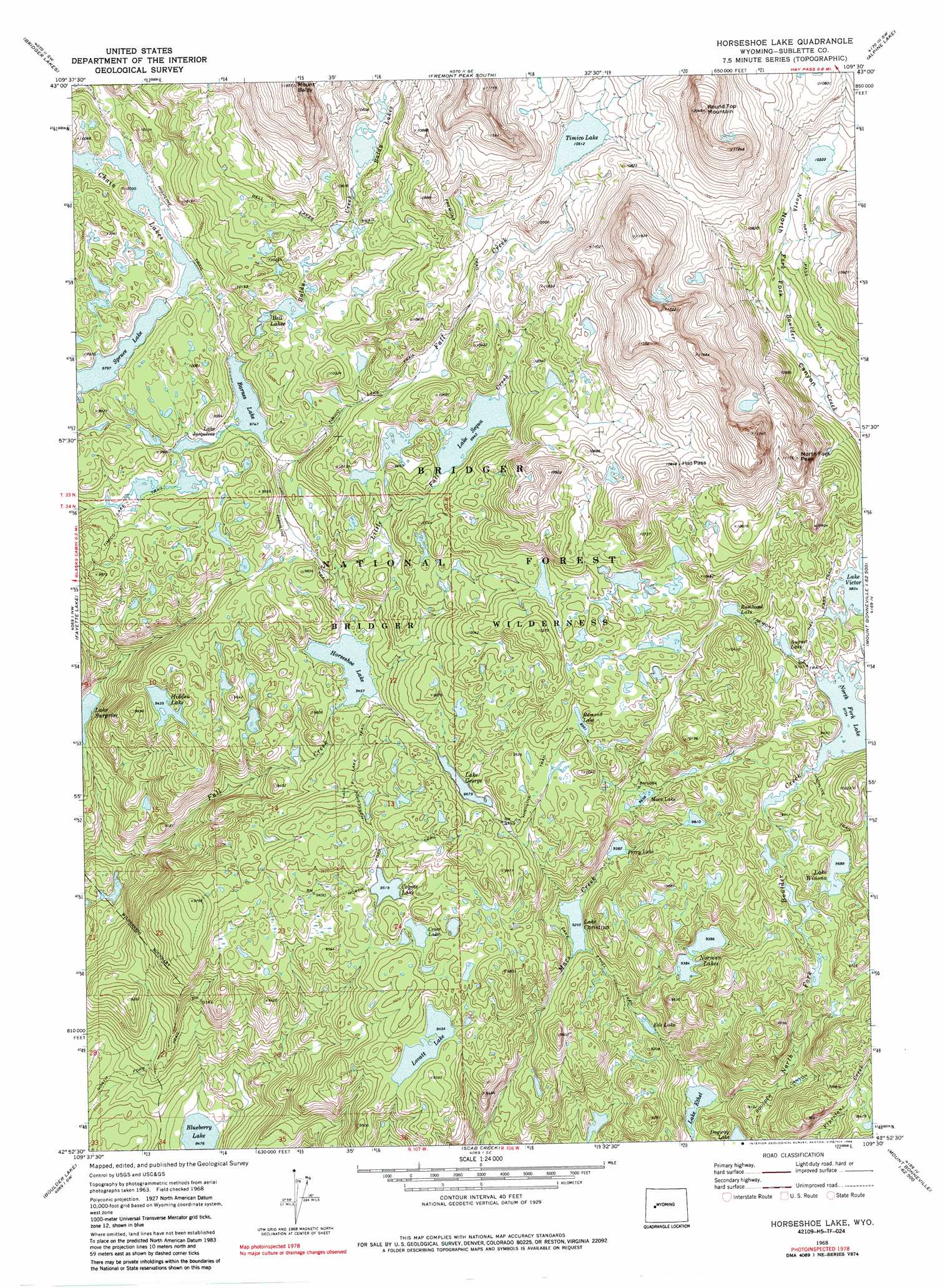
USGS Topo Quad 42109h5 - 1:24,000 scale
| Topo Map Name: | Horseshoe Lake |
| USGS Topo Quad ID: | 42109h5 |
| Print Size: | ca. 21 1/4" wide x 27" high |
| Southeast Coordinates: | 42.875° N latitude / 109.5° W longitude |
| Map Center Coordinates: | 42.9375° N latitude / 109.5625° W longitude |
| U.S. State: | WY |
| Filename: | o42109h5.jpg |
| Download Map JPG Image: | Horseshoe Lake topo map 1:24,000 scale |
| Map Type: | Topographic |
| Topo Series: | 7.5´ |
| Map Scale: | 1:24,000 |
| Source of Map Images: | United States Geological Survey (USGS) |
| Alternate Map Versions: |
Horseshoe Lake WY 1968, updated 1973 Download PDF Buy paper map Horseshoe Lake WY 1968, updated 1976 Download PDF Buy paper map Horseshoe Lake WY 1968, updated 1986 Download PDF Buy paper map Horseshoe Lake WY 1968, updated 1986 Download PDF Buy paper map Horseshoe Lake WY 2012 Download PDF Buy paper map Horseshoe Lake WY 2015 Download PDF Buy paper map |
| FStopo: | US Forest Service topo Horseshoe Lake is available: Download FStopo PDF Download FStopo TIF |
1:24,000 Topo Quads surrounding Horseshoe Lake
Squaretop Mountain |
Gannett Peak |
Fremont Peak North |
Bob Lakes |
Kirkland Park |
Fremont Lake North |
Bridger Lakes |
Fremont Peak South |
Alpine Lake |
Paradise Basin |
Fremont Lake South |
Fayette Lake |
Horseshoe Lake |
Halls Mountain |
Roberts Mountain |
Pinedale |
Boulder Lake |
Scab Creek |
Raid Lake |
Mount Bonneville |
Two Buttes Reservoir |
Boulder |
Fremont Butte |
Pocket Creek Lake |
Big Sandy Opening |
> Back to 42109e1 at 1:100,000 scale
> Back to 42108a1 at 1:250,000 scale
> Back to U.S. Topo Maps home
Horseshoe Lake topo map: Gazetteer
Horseshoe Lake: Gaps
Hat Pass elevation 3317m 10882′Horseshoe Lake: Lakes
August Lake elevation 3008m 9868′Baldy Lakes elevation 3154m 10347′
Barnes Lake elevation 2972m 9750′
Bell Lakes elevation 3044m 9986′
Blueberry Lake elevation 2585m 8480′
Chris Lake elevation 2822m 9258′
Coyote Lake elevation 2903m 9524′
Cross Lake elevation 2909m 9543′
Dugway Lake elevation 2643m 8671′
Edmond Lake elevation 3038m 9967′
Eds Lake elevation 2753m 9032′
Hidden Lake elevation 2877m 9438′
Horseshoe Lake elevation 2884m 9461′
Lake Ethel elevation 2642m 8667′
Lake George elevation 2952m 9685′
Lake Jacquline elevation 2971m 9747′
Lake Sequa elevation 3031m 9944′
Lake Winona elevation 2954m 9691′
Lovatt Lake elevation 2883m 9458′
Macs Lake elevation 2945m 9662′
Norman Lakes elevation 2864m 9396′
North Fork Lake elevation 2975m 9760′
Perry Lake elevation 2861m 9386′
Rambaud Lake elevation 3068m 10065′
Spruce Lake elevation 2988m 9803′
Timico Lake elevation 3206m 10518′
Horseshoe Lake: Ranges
Wind River Range elevation 3264m 10708′Horseshoe Lake: Streams
Little Fall Creek elevation 2916m 9566′Horseshoe Lake: Summits
Mount Baldy elevation 3578m 11738′North Fork Peak elevation 3402m 11161′
Round Top Mountain elevation 3655m 11991′
Horseshoe Lake: Trails
Baldy Lake Trail elevation 3343m 10967′Bell Lakes Trail elevation 3167m 10390′
Hay Pass Trail elevation 3121m 10239′
Horseshoe Lake Trail elevation 2915m 9563′
Lake Ethel Trail elevation 2822m 9258′
Ruff Lake Trail elevation 2804m 9199′
Timico Lake Trail elevation 2963m 9721′
Horseshoe Lake digital topo map on disk
Buy this Horseshoe Lake topo map showing relief, roads, GPS coordinates and other geographical features, as a high-resolution digital map file on DVD: