Halls Mountain Topo Map Wyoming
To zoom in, hover over the map of Halls Mountain
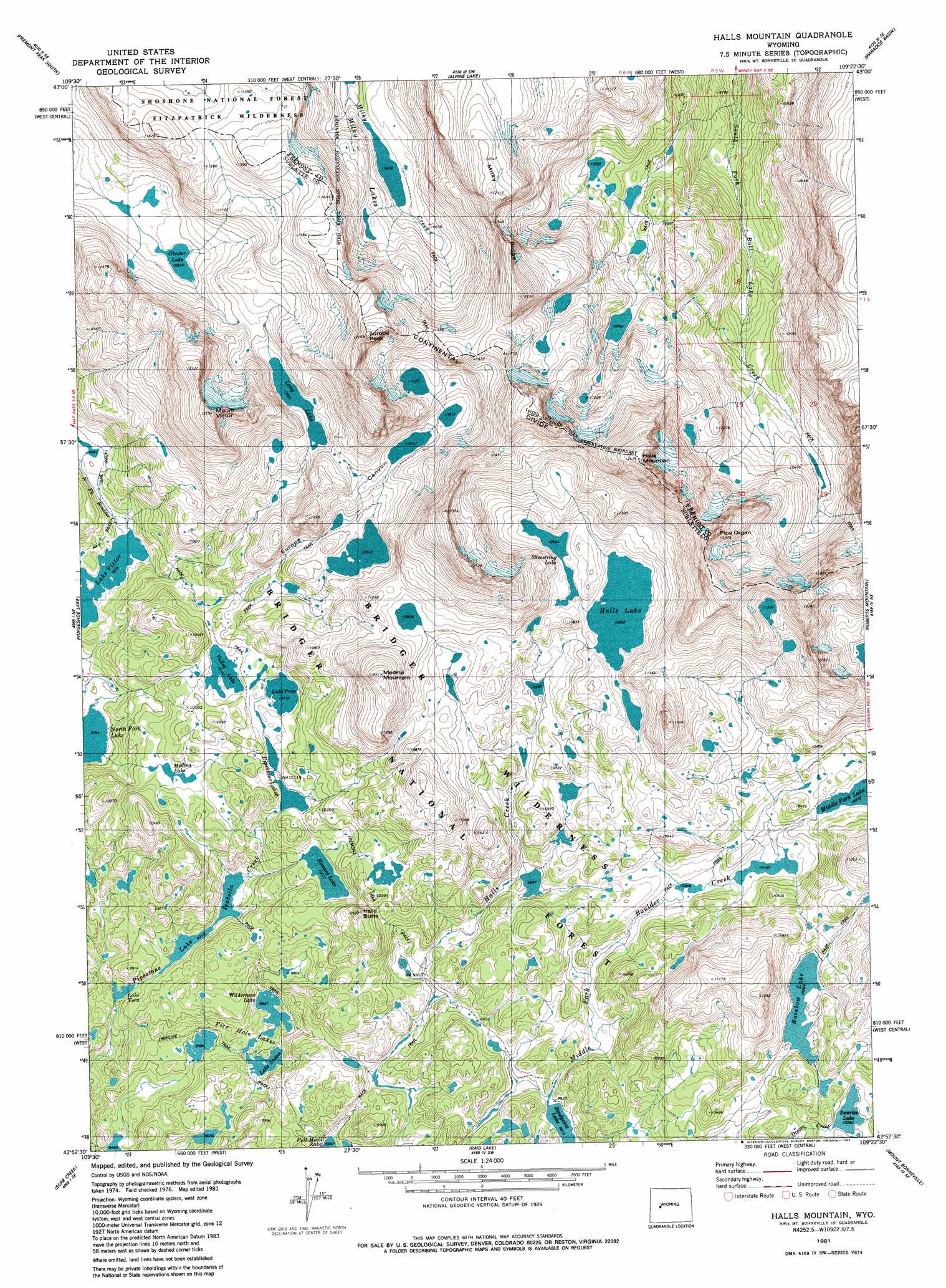
USGS Topo Quad 42109h4 - 1:24,000 scale
| Topo Map Name: | Halls Mountain |
| USGS Topo Quad ID: | 42109h4 |
| Print Size: | ca. 21 1/4" wide x 27" high |
| Southeast Coordinates: | 42.875° N latitude / 109.375° W longitude |
| Map Center Coordinates: | 42.9375° N latitude / 109.4375° W longitude |
| U.S. State: | WY |
| Filename: | o42109h4.jpg |
| Download Map JPG Image: | Halls Mountain topo map 1:24,000 scale |
| Map Type: | Topographic |
| Topo Series: | 7.5´ |
| Map Scale: | 1:24,000 |
| Source of Map Images: | United States Geological Survey (USGS) |
| Alternate Map Versions: |
Halls Mountain WY 1981, updated 1982 Download PDF Buy paper map Halls Mountain WY 1991, updated 1997 Download PDF Buy paper map Halls Mountain WY 2012 Download PDF Buy paper map Halls Mountain WY 2015 Download PDF Buy paper map |
| FStopo: | US Forest Service topo Halls Mountain is available: Download FStopo PDF Download FStopo TIF |
1:24,000 Topo Quads surrounding Halls Mountain
Gannett Peak |
Fremont Peak North |
Bob Lakes |
Kirkland Park |
Bull Lake West |
Bridger Lakes |
Fremont Peak South |
Alpine Lake |
Paradise Basin |
Saint Lawrence Basin |
Fayette Lake |
Horseshoe Lake |
Halls Mountain |
Roberts Mountain |
Washakie Park |
Boulder Lake |
Scab Creek |
Raid Lake |
Mount Bonneville |
Lizard Head Peak |
Boulder |
Fremont Butte |
Pocket Creek Lake |
Big Sandy Opening |
Temple Peak |
> Back to 42109e1 at 1:100,000 scale
> Back to 42108a1 at 1:250,000 scale
> Back to U.S. Topo Maps home
Halls Mountain topo map: Gazetteer
Halls Mountain: Gaps
Photo Pass elevation 3478m 11410′Halls Mountain: Lakes
Fire Hole Lakes elevation 2959m 9708′Glacier Lake elevation 3219m 10561′
Halls Lake elevation 3233m 10606′
Howard Lake elevation 3055m 10022′
Lake Isabella elevation 2964m 9724′
Lake Prue elevation 3097m 10160′
Lake Susan elevation 2938m 9639′
Lake Vera elevation 2934m 9625′
Lake Victor elevation 2999m 9839′
Long Lake elevation 3258m 10688′
Medina Lake elevation 3066m 10059′
Pipestone Lakes elevation 3084m 10118′
Rainbow Lake elevation 3162m 10374′
Sandpoint Lake elevation 2991m 9812′
Shoestring Lake elevation 3253m 10672′
Sunrise Lake elevation 3165m 10383′
Valley Lake elevation 3094m 10150′
Wilderness Lake elevation 2936m 9632′
Halls Mountain: Summits
Europe Peak elevation 3729m 12234′Halls Butte elevation 3189m 10462′
Halls Mountain elevation 3798m 12460′
Medina Mountain elevation 3512m 11522′
Mount Victor elevation 3732m 12244′
Pipe Organ elevation 3711m 12175′
Halls Mountain: Trails
Europe Canyon Trail elevation 3280m 10761′Firehole Trail elevation 3085m 10121′
Halls Lake Trail elevation 3049m 10003′
Lake Isabella Trail elevation 2946m 9665′
Middle Fork Trail elevation 3137m 10291′
Halls Mountain: Valleys
Europe Canyon elevation 3087m 10127′North Fork Canyon elevation 3004m 9855′
Halls Mountain digital topo map on disk
Buy this Halls Mountain topo map showing relief, roads, GPS coordinates and other geographical features, as a high-resolution digital map file on DVD: