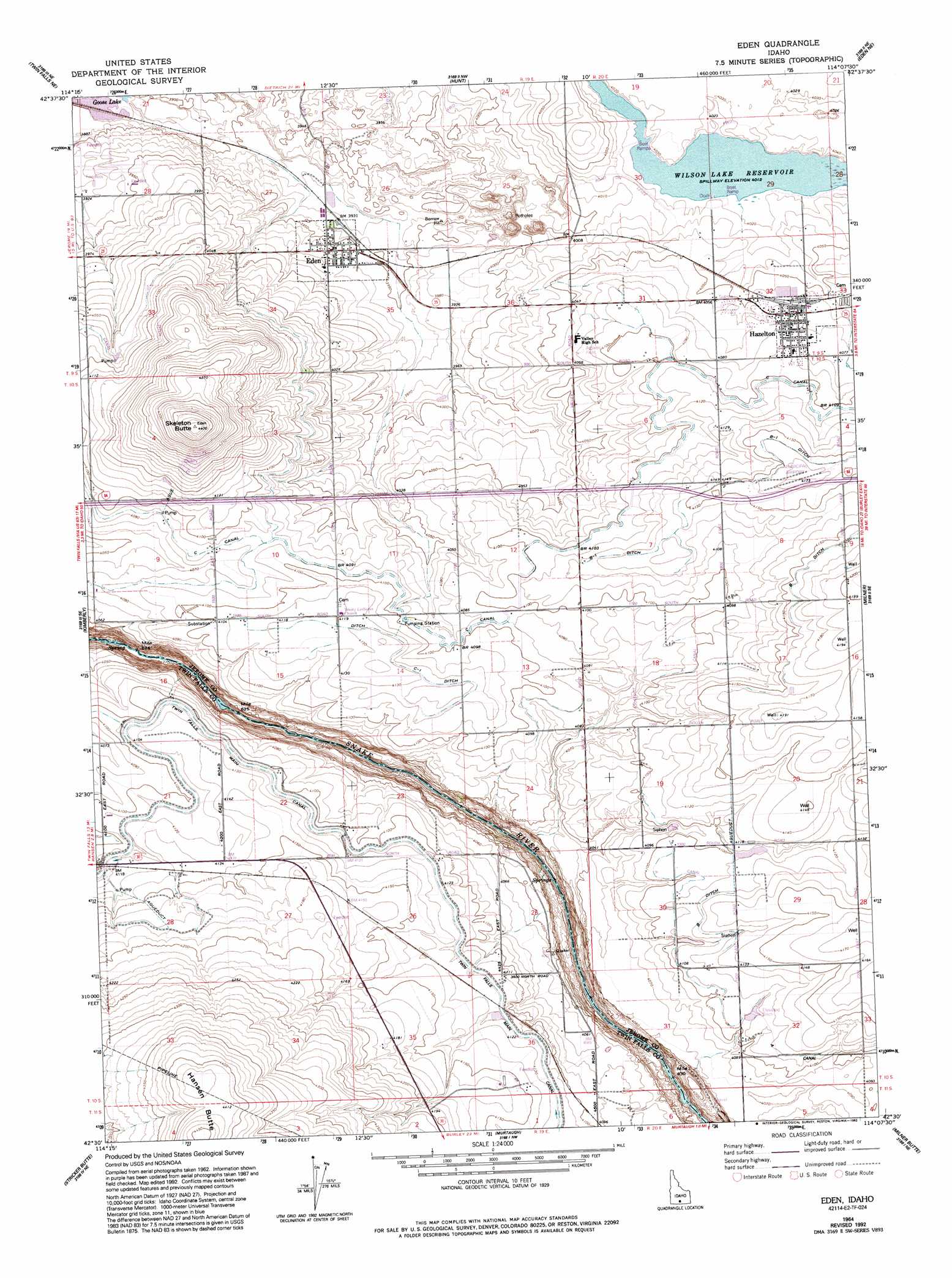
Eden Topo Map Idaho
To zoom in, hover over the map of Eden
USGS Topo Quad 42114e2 - 1:24,000 scale
| Topo Map Name: | Eden |
| USGS Topo Quad ID: | 42114e2 |
| Print Size: | ca. 21 1/4" wide x 27" high |
| Southeast Coordinates: | 42.5° N latitude / 114.125° W longitude |
| Map Center Coordinates: | 42.5625° N latitude / 114.1875° W longitude |
| U.S. State: | ID |
| Filename: | o42114e2.jpg |
| Download Map JPG Image: | Eden topo map 1:24,000 scale |
| Map Type: | Topographic |
| Topo Series: | 7.5´ |
| Map Scale: | 1:24,000 |
| Source of Map Images: | United States Geological Survey (USGS) |
| Alternate Map Versions: |
Eden ID 1964, updated 1965 Download PDF Buy paper map Eden ID 1964, updated 1986 Download PDF Buy paper map Eden ID 1964, updated 1992 Download PDF Buy paper map Eden ID 2010 Download PDF Buy paper map Eden ID 2013 Download PDF Buy paper map |
1:24,000 Topo Quads surrounding Eden
Shoshone Sw |
Shoshone Se |
Star Lake |
Owinza Butte |
Kimama Butte |
Falls City |
Twin Falls Ne |
Hunt |
Eden Ne |
Burley Nw |
Twin Falls |
Kimberly |
Eden |
Milner |
Burley Sw |
Hub Butte |
Stricker Butte |
Murtaugh |
Milner Butte |
Burley Butte |
Mcmullen Basin |
Grand View Peak |
Rams Horn Ridge |
Buckhorn Canyon |
Marion |
> Back to 42114e1 at 1:100,000 scale
> Back to 42114a1 at 1:250,000 scale
> Back to U.S. Topo Maps home
Eden topo map: Gazetteer
Eden: Airports
Hazelton Municipal Airport elevation 1273m 4176′Eden: Canals
A Drain elevation 1248m 4094′B Ditch elevation 1269m 4163′
B-1 Ditch elevation 1265m 4150′
Buschham Spill elevation 1254m 4114′
C Canal elevation 1251m 4104′
C Ditch elevation 1257m 4124′
C-1 Ditch elevation 1259m 4130′
Eden Drain elevation 1201m 3940′
Goose Lake Drain elevation 1187m 3894′
Lateral C-14 elevation 1247m 4091′
Lateral C-17 elevation 1239m 4064′
Lateral C-18 elevation 1252m 4107′
Lateral C-25 elevation 1247m 4091′
Lateral C-32 elevation 1245m 4084′
Lateral C-50 elevation 1245m 4084′
Lateral C-53 elevation 1241m 4071′
Lateral C-59 elevation 1246m 4087′
Lateral C-60 elevation 1248m 4094′
Lateral C-62 elevation 1245m 4084′
Murphy Spill elevation 1251m 4104′
PB Ditch elevation 1269m 4163′
PB-1 Ditch elevation 1266m 4153′
PC Ditch elevation 1258m 4127′
PC-1 Ditch elevation -1m -4′
Plant 3 Pipeline elevation 1252m 4107′
Twin Falls Main Canal elevation 1253m 4110′
Eden: Populated Places
Bickel (historical) elevation 1269m 4163′Eden elevation 1208m 3963′
Hazelton elevation 1242m 4074′
Hillsdale (historical) elevation 1235m 4051′
Eden: Reservoirs
Valley Road Pond elevation 1238m 4061′Eden: Summits
Hansen Butte elevation 1357m 4452′Skeleton Butte elevation 1340m 4396′
Eden digital topo map on disk
Buy this Eden topo map showing relief, roads, GPS coordinates and other geographical features, as a high-resolution digital map file on DVD: