Keg Sprs Valley West Topo Map Oregon
To zoom in, hover over the map of Keg Sprs Valley West
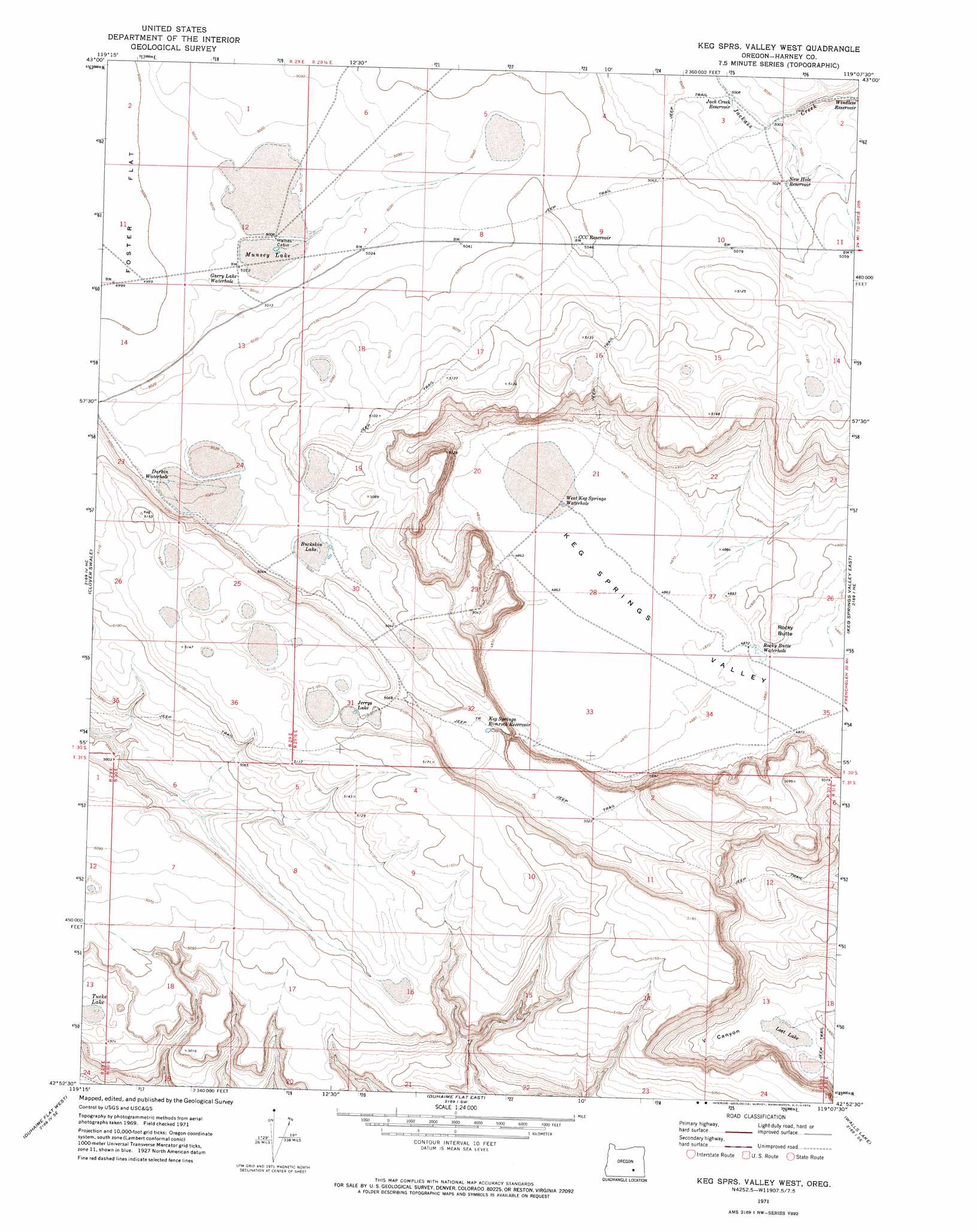
USGS Topo Quad 42119h2 - 1:24,000 scale
| Topo Map Name: | Keg Sprs Valley West |
| USGS Topo Quad ID: | 42119h2 |
| Print Size: | ca. 21 1/4" wide x 27" high |
| Southeast Coordinates: | 42.875° N latitude / 119.125° W longitude |
| Map Center Coordinates: | 42.9375° N latitude / 119.1875° W longitude |
| U.S. State: | OR |
| Filename: | o42119h2.jpg |
| Download Map JPG Image: | Keg Sprs Valley West topo map 1:24,000 scale |
| Map Type: | Topographic |
| Topo Series: | 7.5´ |
| Map Scale: | 1:24,000 |
| Source of Map Images: | United States Geological Survey (USGS) |
| Alternate Map Versions: |
Keg Sprs Valley West OR 1971, updated 1974 Download PDF Buy paper map Keg Springs Valley West OR 2011 Download PDF Buy paper map Keg Springs Valley West OR 2014 Download PDF Buy paper map |
1:24,000 Topo Quads surrounding Keg Sprs Valley West
Lunch Lake |
Hughet Spring |
Southwest Harney Lake |
Southeast Harney Lake |
Coyote Buttes |
Flybee Lake |
Meadow Lake |
Weed Lake Butte |
Twin Buttes |
Jackass Butte |
Balls Lake |
Clover Swale |
Keg Sprs Valley West |
Keg Sprs Valley East |
Irish Lake |
Orejana Canyon |
Duhaime Flat West |
Duhaime Flat East |
Walls Lake |
Frenchglen |
Sixmile Draw |
Murphy Waterholes Ne |
Blitzen Nw |
Butler Hill |
Roaring Springs |
> Back to 42119e1 at 1:100,000 scale
> Back to 42118a1 at 1:250,000 scale
> Back to U.S. Topo Maps home
Keg Sprs Valley West topo map: Gazetteer
Keg Sprs Valley West: Flats
Buckskin Lake elevation 1534m 5032′Jerrys Lake elevation 1552m 5091′
Lost Lake elevation 1487m 4878′
Munsey Lake elevation 1528m 5013′
Tucke Lake elevation 1518m 4980′
Keg Sprs Valley West: Lakes
Camel Lake elevation 1531m 5022′Durbin Waterhole elevation 1530m 5019′
Garry Lake Waterhole elevation 1528m 5013′
Rocky Butte Waterhole elevation 1488m 4881′
West Keg Springs Waterhole elevation 1486m 4875′
Keg Sprs Valley West: Reservoirs
CCC Reservoir elevation 1540m 5052′Jack Creek Reservoir elevation 1528m 5013′
Keg Springs Rimrock Reservoir elevation 1525m 5003′
New Hole Reservoir elevation 1532m 5026′
Windless Reservoir elevation 1526m 5006′
Keg Sprs Valley West: Summits
Rocky Butte elevation 1502m 4927′Keg Sprs Valley West: Valleys
V Canyon elevation 1487m 4878′Keg Sprs Valley West digital topo map on disk
Buy this Keg Sprs Valley West topo map showing relief, roads, GPS coordinates and other geographical features, as a high-resolution digital map file on DVD: