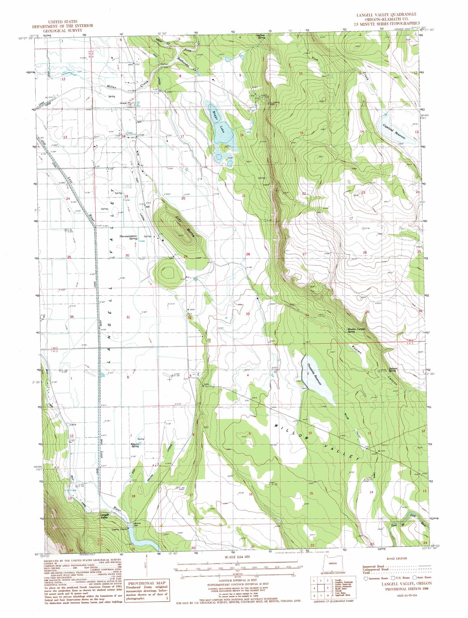
Langell Valley Topo Map Oregon
To zoom in, hover over the map of Langell Valley
USGS Topo Quad 42121a2 - 1:24,000 scale
| Topo Map Name: | Langell Valley |
| USGS Topo Quad ID: | 42121a2 |
| Print Size: | ca. 21 1/4" wide x 27" high |
| Southeast Coordinates: | 42° N latitude / 121.125° W longitude |
| Map Center Coordinates: | 42.0625° N latitude / 121.1875° W longitude |
| U.S. State: | OR |
| Filename: | o42121a2.jpg |
| Download Map JPG Image: | Langell Valley topo map 1:24,000 scale |
| Map Type: | Topographic |
| Topo Series: | 7.5´ |
| Map Scale: | 1:24,000 |
| Source of Map Images: | United States Geological Survey (USGS) |
| Alternate Map Versions: |
Langell Valley OR 1988, updated 1988 Download PDF Buy paper map Langell Valley OR 2011 Download PDF Buy paper map Langell Valley OR 2014 Download PDF Buy paper map |
1:24,000 Topo Quads surrounding Langell Valley
Yonna |
Yainax Butte |
Dry Prairie |
Horsefly Mountain |
Paradise Mountain |
Bonanza |
Lorella |
Goodlow Mountain |
Gerber Reservoir |
Barnes Valley |
Malin |
Bryant Mountain |
Langell Valley |
Brady Butte |
Antler Point |
Tulelake |
Newell |
Carr Butte |
Sagebrush Butte |
Steele Swamp |
The Panhandle |
Copic |
Double Head Mountain |
Pinnacle Lake |
Pothole Valley |
> Back to 42121a1 at 1:100,000 scale
> Back to 42120a1 at 1:250,000 scale
> Back to U.S. Topo Maps home
Langell Valley topo map: Gazetteer
Langell Valley: Canals
East Lateral elevation 1275m 4183′East Malone Lateral elevation 1268m 4160′
Willow Valley Canal elevation 1348m 4422′
Langell Valley: Dams
Malone Dam elevation 1263m 4143′Malone Diversion Dam elevation 1294m 4245′
Threemile Dam elevation 1330m 4363′
Langell Valley: Flats
Threemile Flat elevation 1341m 4399′Willow Valley elevation 1316m 4317′
Langell Valley: Lakes
Boggs Lake elevation 1290m 4232′Langell Valley: Populated Places
Langell Valley elevation 1264m 4146′Langell Valley: Post Offices
Langell Valley Post Office (historical) elevation 1264m 4146′Langell Valley: Reservoirs
Copeland Reservoir elevation 1485m 4872′Malone Pool elevation 1294m 4245′
Threemile Reservoir elevation 1330m 4363′
Langell Valley: Springs
Dry Spring elevation 1314m 4311′Hargadine Spring elevation 1261m 4137′
Heffner Spring elevation 1360m 4461′
Kilgore Spring elevation 1262m 4140′
Pre-exemption Spring elevation 1262m 4140′
Sullivan Spring elevation 1391m 4563′
Woolen Canyon Spring elevation 1349m 4425′
Langell Valley: Streams
Black Canyon Creek elevation 1267m 4156′Pine Creek elevation 1269m 4163′
Rattlesnake Creek elevation 1267m 4156′
Langell Valley: Summits
Gift Butte elevation 1352m 4435′Langell Valley: Valleys
Woolen Canyon elevation 1285m 4215′Langell Valley digital topo map on disk
Buy this Langell Valley topo map showing relief, roads, GPS coordinates and other geographical features, as a high-resolution digital map file on DVD: