Bryant Mountain Topo Map Oregon
To zoom in, hover over the map of Bryant Mountain
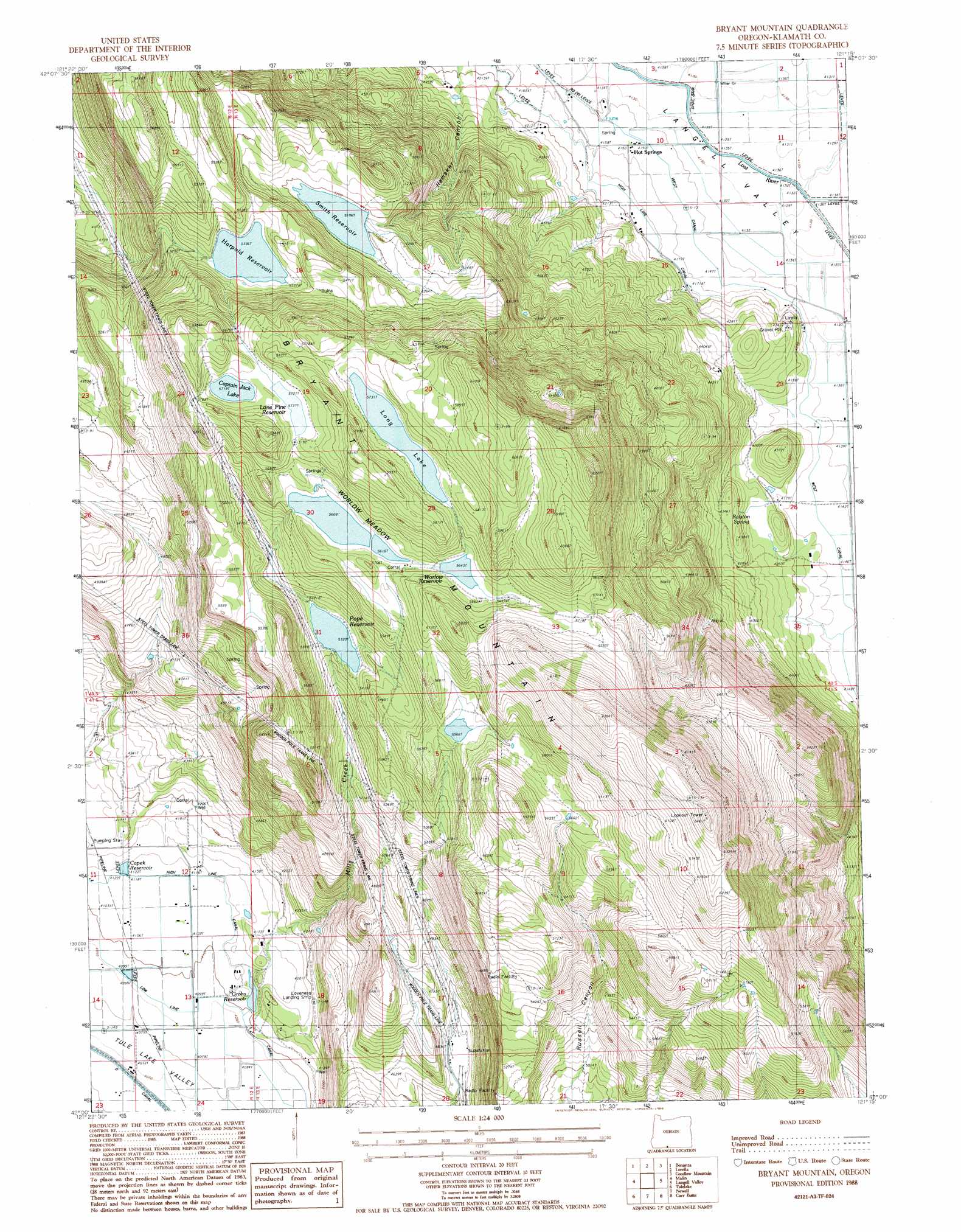
USGS Topo Quad 42121a3 - 1:24,000 scale
| Topo Map Name: | Bryant Mountain |
| USGS Topo Quad ID: | 42121a3 |
| Print Size: | ca. 21 1/4" wide x 27" high |
| Southeast Coordinates: | 42° N latitude / 121.25° W longitude |
| Map Center Coordinates: | 42.0625° N latitude / 121.3125° W longitude |
| U.S. State: | OR |
| Filename: | o42121a3.jpg |
| Download Map JPG Image: | Bryant Mountain topo map 1:24,000 scale |
| Map Type: | Topographic |
| Topo Series: | 7.5´ |
| Map Scale: | 1:24,000 |
| Source of Map Images: | United States Geological Survey (USGS) |
| Alternate Map Versions: |
Bryant Mountain OR 1988, updated 1988 Download PDF Buy paper map Bryant Mountain OR 2011 Download PDF Buy paper map Bryant Mountain OR 2014 Download PDF Buy paper map |
1:24,000 Topo Quads surrounding Bryant Mountain
Swan Lake |
Yonna |
Yainax Butte |
Dry Prairie |
Horsefly Mountain |
Dairy |
Bonanza |
Lorella |
Goodlow Mountain |
Gerber Reservoir |
Merrill |
Malin |
Bryant Mountain |
Langell Valley |
Brady Butte |
Hatfield |
Tulelake |
Newell |
Carr Butte |
Sagebrush Butte |
Captain Jacks Stronghold |
The Panhandle |
Copic |
Double Head Mountain |
Pinnacle Lake |
> Back to 42121a1 at 1:100,000 scale
> Back to 42120a1 at 1:250,000 scale
> Back to U.S. Topo Maps home
Bryant Mountain topo map: Gazetteer
Bryant Mountain: Canals
West Canal elevation 1265m 4150′Bryant Mountain: Dams
Gulch Dam elevation 1253m 4110′McCoy Dam elevation 1710m 5610′
Smith Dam elevation 1585m 5200′
Worlow Dam elevation 1722m 5649′
Bryant Mountain: Lakes
Captain Jack Lake elevation 1744m 5721′Bryant Mountain: Populated Places
Hot Springs elevation 1266m 4153′Tule Lake (historical) elevation 1268m 4160′
Bryant Mountain: Post Offices
Tule Lake Post Office (historical) elevation 1268m 4160′Bryant Mountain: Reservoirs
Capek Reservoir elevation 1256m 4120′Dearborn Reservoir elevation 1291m 4235′
Fivemile Reservoir elevation 1653m 5423′
Grohs Reservoir elevation 1257m 4124′
Harpold Reservoir elevation 1628m 5341′
Lone Pine Reservoir elevation 1748m 5734′
Long Lake elevation 1748m 5734′
McCoy Reservoir elevation 1710m 5610′
Pope Reservoir elevation 1623m 5324′
Smith Reservoir elevation 1585m 5200′
Worlow Reservoir elevation 1722m 5649′
Bryant Mountain: Springs
McCoy Spring elevation 1719m 5639′Ralston Spring elevation 1357m 4452′
Bryant Mountain: Streams
Miller Creek elevation 1257m 4124′Mills Creek elevation 1262m 4140′
Wooden Creek elevation 1430m 4691′
Bryant Mountain: Summits
Bryant Mountain elevation 1946m 6384′Bryant Mountain: Swamps
Worlow Meadow elevation 1710m 5610′Bryant Mountain: Valleys
Hamaker Canyon elevation 1283m 4209′Bryant Mountain digital topo map on disk
Buy this Bryant Mountain topo map showing relief, roads, GPS coordinates and other geographical features, as a high-resolution digital map file on DVD: