Soda Mountain Topo Map Oregon
To zoom in, hover over the map of Soda Mountain
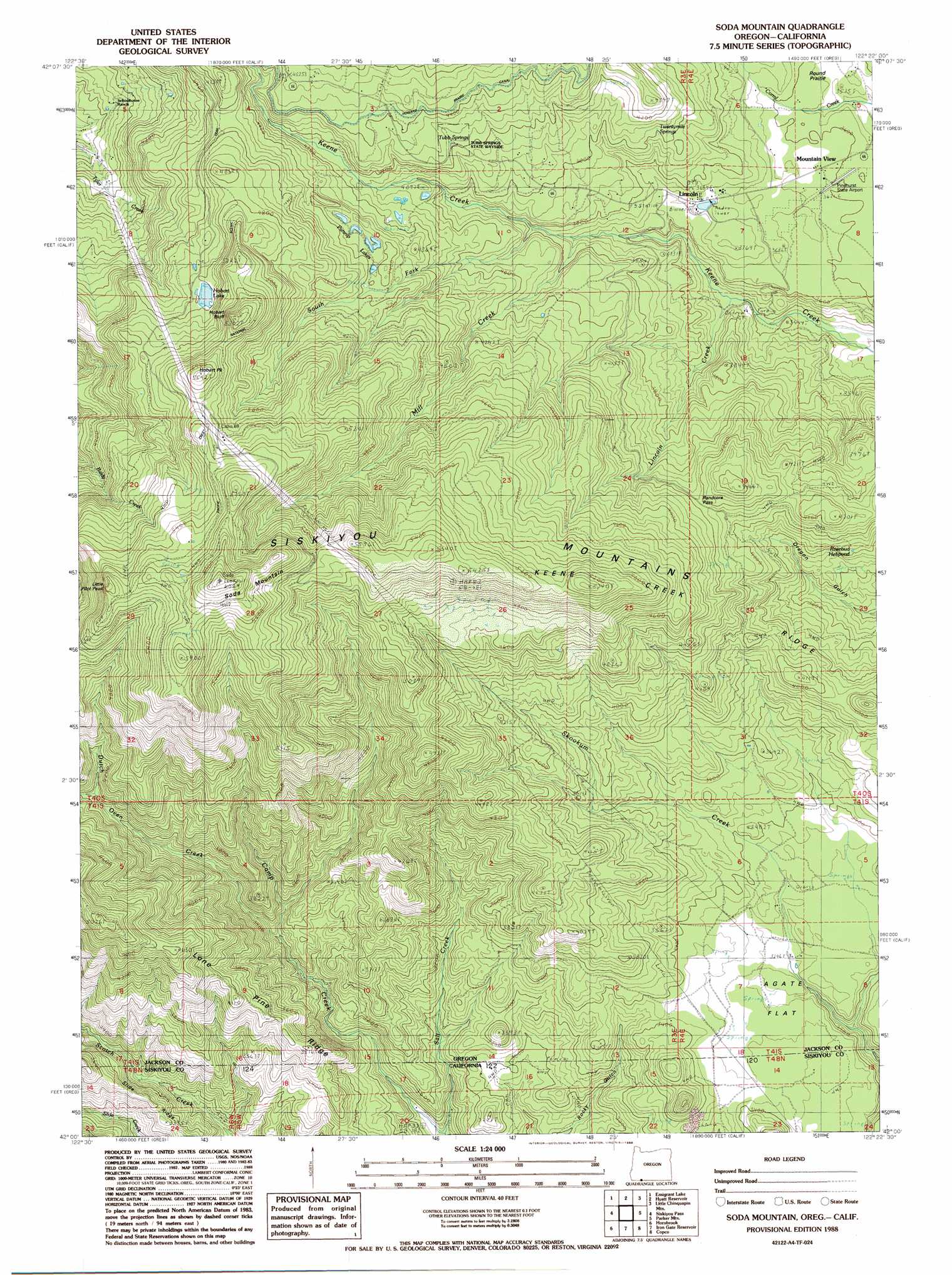
USGS Topo Quad 42122a4 - 1:24,000 scale
| Topo Map Name: | Soda Mountain |
| USGS Topo Quad ID: | 42122a4 |
| Print Size: | ca. 21 1/4" wide x 27" high |
| Southeast Coordinates: | 42° N latitude / 122.375° W longitude |
| Map Center Coordinates: | 42.0625° N latitude / 122.4375° W longitude |
| U.S. States: | OR, CA |
| Filename: | o42122a4.jpg |
| Download Map JPG Image: | Soda Mountain topo map 1:24,000 scale |
| Map Type: | Topographic |
| Topo Series: | 7.5´ |
| Map Scale: | 1:24,000 |
| Source of Map Images: | United States Geological Survey (USGS) |
| Alternate Map Versions: |
Soda Mountain OR 1988, updated 1988 Download PDF Buy paper map Soda Mountain OR 1988, updated 1988 Download PDF Buy paper map Soda Mountain OR 2011 Download PDF Buy paper map Soda Mountain OR 2014 Download PDF Buy paper map |
| FStopo: | US Forest Service topo Soda Mountain is available: Download FStopo PDF Download FStopo TIF |
1:24,000 Topo Quads surrounding Soda Mountain
Rio Canyon |
Grizzly Peak |
Robinson Butte |
Brown Mountain |
Lake Of The Woods South |
Ashland |
Emigrant Lake |
Hyatt Reservoir |
Little Chinquapin Mountain |
Surveyor Mountain |
Mount Ashland |
Siskiyou Pass |
Soda Mountain |
Parker Mountain |
Mule Hill |
Cottonwood Peak |
Hornbrook |
Iron Gate Reservoir |
Copco |
Secret Spring Mountain |
Badger Mountain |
Hawkinsville |
Bogus Mountain |
Dewey Gulch |
Panther Rock |
> Back to 42122a1 at 1:100,000 scale
> Back to 42122a1 at 1:250,000 scale
> Back to U.S. Topo Maps home
Soda Mountain topo map: Gazetteer
Soda Mountain: Airports
Pinehurst State Airport elevation 1106m 3628′Soda Mountain: Cliffs
Hobart Bluff elevation 1581m 5187′Soda Mountain: Flats
Agate Flat elevation 1001m 3284′Round Prairie elevation 1076m 3530′
Soda Mountain: Gaps
Randcore Pass elevation 1273m 4176′Soda Mountain: Lakes
Hobart Lake elevation 1459m 4786′Parsnip Lakes elevation 1317m 4320′
Rosebud Helipond elevation 1155m 3789′
Soda Mountain: Parks
Tub Springs State Park elevation 1282m 4206′Soda Mountain: Populated Places
Lincoln elevation 1128m 3700′Mountain View elevation 1103m 3618′
Soda Mountain: Ridges
Keene Creek Ridge elevation 1426m 4678′Lone Pine Ridge elevation 1155m 3789′
Lone Pine Ridge elevation 1407m 4616′
Soda Mountain: Springs
Tub Springs elevation 1175m 3854′Twentymile Springs elevation 1226m 4022′
Soda Mountain: Streams
Dutch Oven Creek elevation 972m 3188′Lincoln Creek elevation 1041m 3415′
Mill Creek elevation 1123m 3684′
South Fork Keene Creek elevation 1145m 3756′
Soda Mountain: Summits
Boccard Point elevation 1794m 5885′Hobart Peak elevation 1677m 5501′
Little Pilot Peak elevation 1716m 5629′
Soda Mountain elevation 1857m 6092′
Soda Mountain: Valleys
Devils Gulch elevation 1197m 3927′Soda Mountain digital topo map on disk
Buy this Soda Mountain topo map showing relief, roads, GPS coordinates and other geographical features, as a high-resolution digital map file on DVD: