Coleman Ne Topo Map Michigan
To zoom in, hover over the map of Coleman Ne
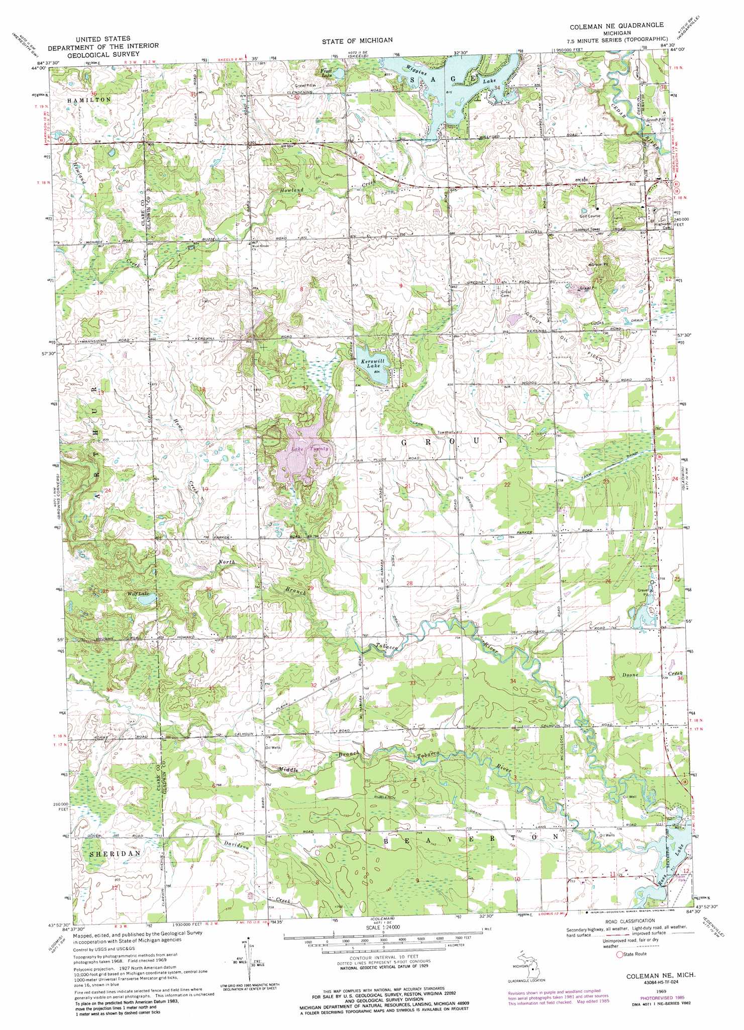
USGS Topo Quad 43084h5 - 1:24,000 scale
| Topo Map Name: | Coleman Ne |
| USGS Topo Quad ID: | 43084h5 |
| Print Size: | ca. 21 1/4" wide x 27" high |
| Southeast Coordinates: | 43.875° N latitude / 84.5° W longitude |
| Map Center Coordinates: | 43.9375° N latitude / 84.5625° W longitude |
| U.S. State: | MI |
| Filename: | o43084h5.jpg |
| Download Map JPG Image: | Coleman Ne topo map 1:24,000 scale |
| Map Type: | Topographic |
| Topo Series: | 7.5´ |
| Map Scale: | 1:24,000 |
| Source of Map Images: | United States Geological Survey (USGS) |
| Alternate Map Versions: |
Coleman NE MI 1969, updated 1972 Download PDF Buy paper map Coleman NE MI 1969, updated 1985 Download PDF Buy paper map Coleman NE MI 2011 Download PDF Buy paper map Coleman NE MI 2014 Download PDF Buy paper map Coleman NE MI 2016 Download PDF Buy paper map |
1:24,000 Topo Quads surrounding Coleman Ne
Cooperton |
Meredith Nw |
Meredith |
Butman |
Edwards |
Harrison |
Meredith Sw |
Skeels |
Wagarville |
Secord Lake |
Hatton |
Browns Corners |
Coleman Ne |
Gladwin |
Wooden Shoe Village |
Clare |
Loomis |
Coleman |
Edenville |
Hope |
Rosebush |
Leaton |
Alamando |
Sanford |
Averill |
> Back to 43084e1 at 1:100,000 scale
> Back to 43084a1 at 1:250,000 scale
> Back to U.S. Topo Maps home
Coleman Ne topo map: Gazetteer
Coleman Ne: Canals
Burleson Drain elevation 225m 738′Carr Drain elevation 241m 790′
Price Drain elevation 234m 767′
Coleman Ne: Lakes
Big Lake Twenty elevation 242m 793′Frost Lake elevation 253m 830′
Kerswill Lake elevation 245m 803′
Little Lake Twenty elevation 242m 793′
Wiggins Lake elevation 248m 813′
Wolf Lake elevation 236m 774′
Coleman Ne: Oilfields
Grout Oil Field elevation 251m 823′Coleman Ne: Populated Places
Lakeview Village Mobile Home Park elevation 221m 725′Coleman Ne: Post Offices
Bard Post Office (historical) elevation 235m 770′Grout Post Office (historical) elevation 266m 872′
Wheatley Post Office (historical) elevation 274m 898′
Coleman Ne: Streams
Howe Creek elevation 237m 777′Howland Creek elevation 248m 813′
Middle Branch Tobacco River elevation 217m 711′
North Branch Tobacco River elevation 217m 711′
South Branch Tobacco River elevation 217m 711′
Coleman Ne digital topo map on disk
Buy this Coleman Ne topo map showing relief, roads, GPS coordinates and other geographical features, as a high-resolution digital map file on DVD: