Meredith Sw Topo Map Michigan
To zoom in, hover over the map of Meredith Sw
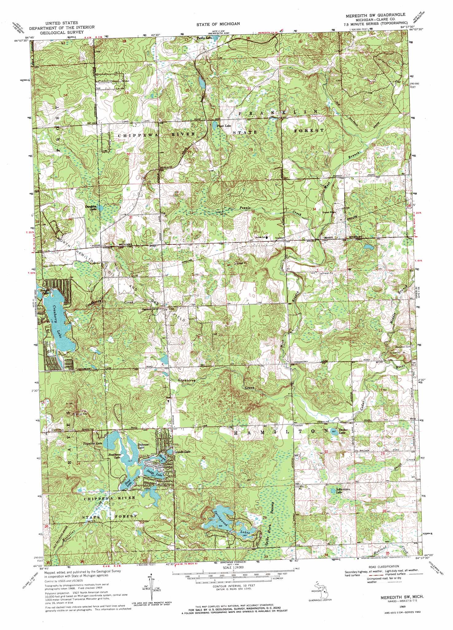
USGS Topo Quad 44084a6 - 1:24,000 scale
| Topo Map Name: | Meredith Sw |
| USGS Topo Quad ID: | 44084a6 |
| Print Size: | ca. 21 1/4" wide x 27" high |
| Southeast Coordinates: | 44° N latitude / 84.625° W longitude |
| Map Center Coordinates: | 44.0625° N latitude / 84.6875° W longitude |
| U.S. State: | MI |
| Filename: | o44084a6.jpg |
| Download Map JPG Image: | Meredith Sw topo map 1:24,000 scale |
| Map Type: | Topographic |
| Topo Series: | 7.5´ |
| Map Scale: | 1:24,000 |
| Source of Map Images: | United States Geological Survey (USGS) |
| Alternate Map Versions: |
Meredith SW MI 1969, updated 1971 Download PDF Buy paper map Meredith SW MI 1969, updated 1971 Download PDF Buy paper map Meredith SW MI 2011 Download PDF Buy paper map Meredith SW MI 2014 Download PDF Buy paper map Meredith SW MI 2017 Download PDF Buy paper map |
1:24,000 Topo Quads surrounding Meredith Sw
Merritt |
Houghton Lake |
Prudenville |
Backus Lake |
Saint Helen |
Moddersville |
Cooperton |
Meredith Nw |
Meredith |
Butman |
Prestle Creek |
Harrison |
Meredith Sw |
Skeels |
Wagarville |
Lake George |
Hatton |
Browns Corners |
Coleman Ne |
Gladwin |
Woods |
Clare |
Loomis |
Coleman |
Edenville |
> Back to 44084a1 at 1:100,000 scale
> Back to 44084a1 at 1:250,000 scale
> Back to U.S. Topo Maps home
Meredith Sw topo map: Gazetteer
Meredith Sw: Lakes
Boathouse Lake elevation 310m 1017′Canada Lake elevation 310m 1017′
Cranberry Lake elevation 348m 1141′
Decker Lake elevation 276m 905′
Dodge Lake elevation 309m 1013′
Dunham Lake elevation 355m 1164′
Frost Lake elevation 336m 1102′
Haven Lake elevation 310m 1017′
Icehouse Lake elevation 310m 1017′
Sand Lake elevation 310m 1017′
Schiemann Lake elevation 289m 948′
Springwood Lakes elevation 295m 967′
Townline Lake elevation 310m 1017′
Tuohy Lake elevation 361m 1184′
Meredith Sw: Oilfields
North Hamilton Oil and Gas Field elevation 334m 1095′Meredith Sw: Streams
Cranberry Creek elevation 277m 908′Middle Branch Cedar River elevation 268m 879′
Popple Creek elevation 302m 990′
West Branch Cedar River elevation 277m 908′
Meredith Sw: Swamps
Spike Horn Swamp elevation 287m 941′Meredith Sw digital topo map on disk
Buy this Meredith Sw topo map showing relief, roads, GPS coordinates and other geographical features, as a high-resolution digital map file on DVD: