Albert Lea East Topo Map Minnesota
To zoom in, hover over the map of Albert Lea East
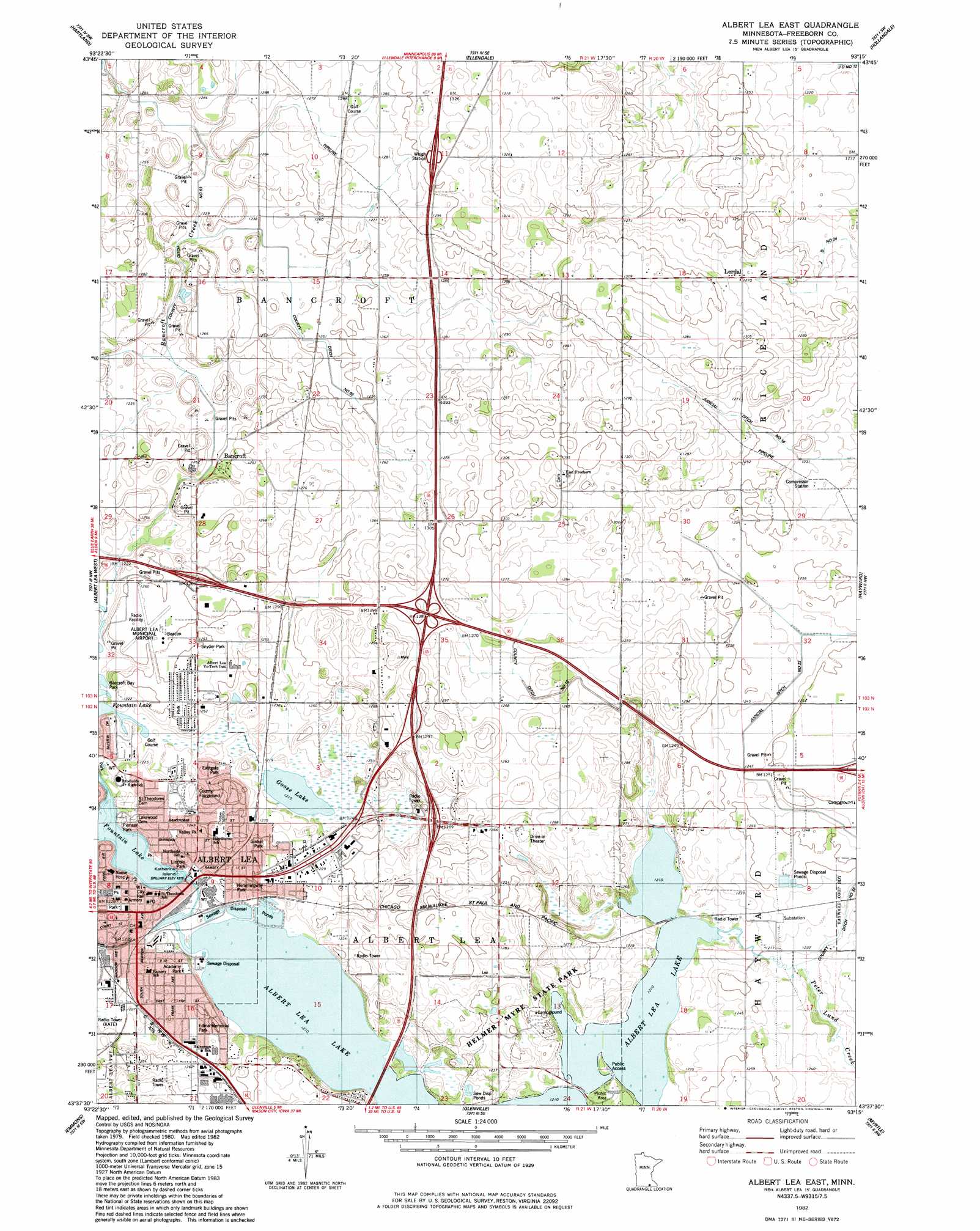
USGS Topo Quad 43093f3 - 1:24,000 scale
| Topo Map Name: | Albert Lea East |
| USGS Topo Quad ID: | 43093f3 |
| Print Size: | ca. 21 1/4" wide x 27" high |
| Southeast Coordinates: | 43.625° N latitude / 93.25° W longitude |
| Map Center Coordinates: | 43.6875° N latitude / 93.3125° W longitude |
| U.S. State: | MN |
| Filename: | o43093f3.jpg |
| Download Map JPG Image: | Albert Lea East topo map 1:24,000 scale |
| Map Type: | Topographic |
| Topo Series: | 7.5´ |
| Map Scale: | 1:24,000 |
| Source of Map Images: | United States Geological Survey (USGS) |
| Alternate Map Versions: |
Albert Lea East MN 1982, updated 1983 Download PDF Buy paper map Albert Lea East MN 2010 Download PDF Buy paper map Albert Lea East MN 2013 Download PDF Buy paper map Albert Lea East MN 2016 Download PDF Buy paper map |
1:24,000 Topo Quads surrounding Albert Lea East
Otisco |
New Richland |
Hope |
Steele Center |
Bixby |
Freeborn |
Hartland |
Ellendale |
Hollandale |
Blooming Prairie |
Alden |
Albert Lea West |
Albert Lea East |
Hayward |
Austin West |
Conger |
Emmons |
Glenville |
Myrtle |
London |
Lake Mills |
Bristol |
Fertile Ne |
Northwood |
Carpenter |
> Back to 43093e1 at 1:100,000 scale
> Back to 43092a1 at 1:250,000 scale
> Back to U.S. Topo Maps home
Albert Lea East topo map: Gazetteer
Albert Lea East: Airports
Albert Lea Municipal Airport elevation 381m 1250′Albert Lea East: Canals
County Ditch Number Fifteen elevation 382m 1253′County Ditch Number Sixtyfive elevation 378m 1240′
County Ditch Number Thirtytwo elevation 372m 1220′
County Ditch Number Twentytwo elevation 375m 1230′
Albert Lea East: Crossings
Interchange 11 elevation 383m 1256′Interchange 12 elevation 395m 1295′
Interchange 157 elevation 381m 1250′
Interchange 159 elevation 387m 1269′
Albert Lea East: Dams
Fountain Lake Dam elevation 372m 1220′Albert Lea East: Islands
Katherine Island elevation 370m 1213′Albert Lea East: Lakes
Goose Lake elevation 370m 1213′Albert Lea East: Parks
Academy Park elevation 378m 1240′Central Park elevation 379m 1243′
Eastgate Park elevation 378m 1240′
Edina Memorial Park elevation 378m 1240′
Fountain Lake Park elevation 371m 1217′
Frank Hall Park elevation 371m 1217′
Ginkel Park elevation 379m 1243′
Hawthorne Park elevation 381m 1250′
Hemmingway Park elevation 376m 1233′
Lincoln Park elevation 372m 1220′
Mexicans in Minnesota Historical Marker elevation 377m 1236′
Morin Park elevation 371m 1217′
Pioneer Park elevation 376m 1233′
Snyder Park elevation 383m 1256′
Troy Hammer Park elevation 382m 1253′
Valley Park elevation 375m 1230′
Albert Lea East: Populated Places
Albert Lea elevation 379m 1243′Bancroft elevation 378m 1240′
Lerdal elevation 387m 1269′
Albert Lea East: Post Offices
Albert Lea Post Office elevation 379m 1243′Bancroft Post Office (historical) elevation 378m 1240′
Lerdal Post Office (historical) elevation 387m 1269′
Albert Lea East: Reservoirs
Fountain Lake elevation 372m 1220′Albert Lea East: Streams
Bancroft Creek elevation 378m 1240′Peter Lund Creek elevation 369m 1210′
Albert Lea East digital topo map on disk
Buy this Albert Lea East topo map showing relief, roads, GPS coordinates and other geographical features, as a high-resolution digital map file on DVD: