Mexican Pass Topo Map Wyoming
To zoom in, hover over the map of Mexican Pass
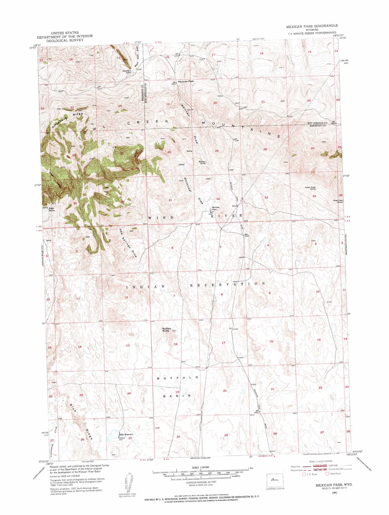
USGS Topo Quad 43108d4 - 1:24,000 scale
| Topo Map Name: | Mexican Pass |
| USGS Topo Quad ID: | 43108d4 |
| Print Size: | ca. 21 1/4" wide x 27" high |
| Southeast Coordinates: | 43.375° N latitude / 108.375° W longitude |
| Map Center Coordinates: | 43.4375° N latitude / 108.4375° W longitude |
| U.S. State: | WY |
| Filename: | o43108d4.jpg |
| Download Map JPG Image: | Mexican Pass topo map 1:24,000 scale |
| Map Type: | Topographic |
| Topo Series: | 7.5´ |
| Map Scale: | 1:24,000 |
| Source of Map Images: | United States Geological Survey (USGS) |
| Alternate Map Versions: |
Mexican Pass WY 1951, updated 1953 Download PDF Buy paper map Mexican Pass WY 2012 Download PDF Buy paper map Mexican Pass WY 2015 Download PDF Buy paper map |
1:24,000 Topo Quads surrounding Mexican Pass
Embar |
Arapahoe Ranch |
Thompson Reservoirs |
Rattlesnake Gulch |
Thermoplis |
Sheep Ridge |
Kates Basin |
Potato Butte |
Nostrum Mountain |
Wedding Of The Waters |
Shotgun Butte |
Jenkins Mountain |
Mexican Pass |
Morrison Canyon |
Boysen |
Pavillion Butte |
Harris Bridge |
Mexican Pass Sw |
Mexican Pass Se |
Bonneville Sw |
Pavillion |
Ocean Lake |
Lost Wells Butte |
Riverton Ne |
Hidden Valley |
> Back to 43108a1 at 1:100,000 scale
> Back to 43108a1 at 1:250,000 scale
> Back to U.S. Topo Maps home
Mexican Pass topo map: Gazetteer
Mexican Pass: Gaps
Mexican Pass elevation 1909m 6263′Mexican Pass: Reservoirs
Blue Reservoir elevation 1540m 5052′Mexican Pass: Ridges
Arrowhead Ridge elevation 2245m 7365′Mexican Pass: Springs
Black Rock Spring elevation 1945m 6381′Indian Trails Spring elevation 1682m 5518′
Mexican Spring elevation 1706m 5597′
Water Cress Spring elevation 1709m 5606′
Mexican Pass: Summits
Buffalo Butte elevation 1594m 5229′Mexican Pass: Valleys
Engle Canyon elevation 1774m 5820′Mexican Draw elevation 1517m 4977′
Shearing Pen Draw elevation 1509m 4950′
Whitticker Draw elevation 1605m 5265′
Mexican Pass digital topo map on disk
Buy this Mexican Pass topo map showing relief, roads, GPS coordinates and other geographical features, as a high-resolution digital map file on DVD: