Commissary Ridge Topo Map Idaho
To zoom in, hover over the map of Commissary Ridge
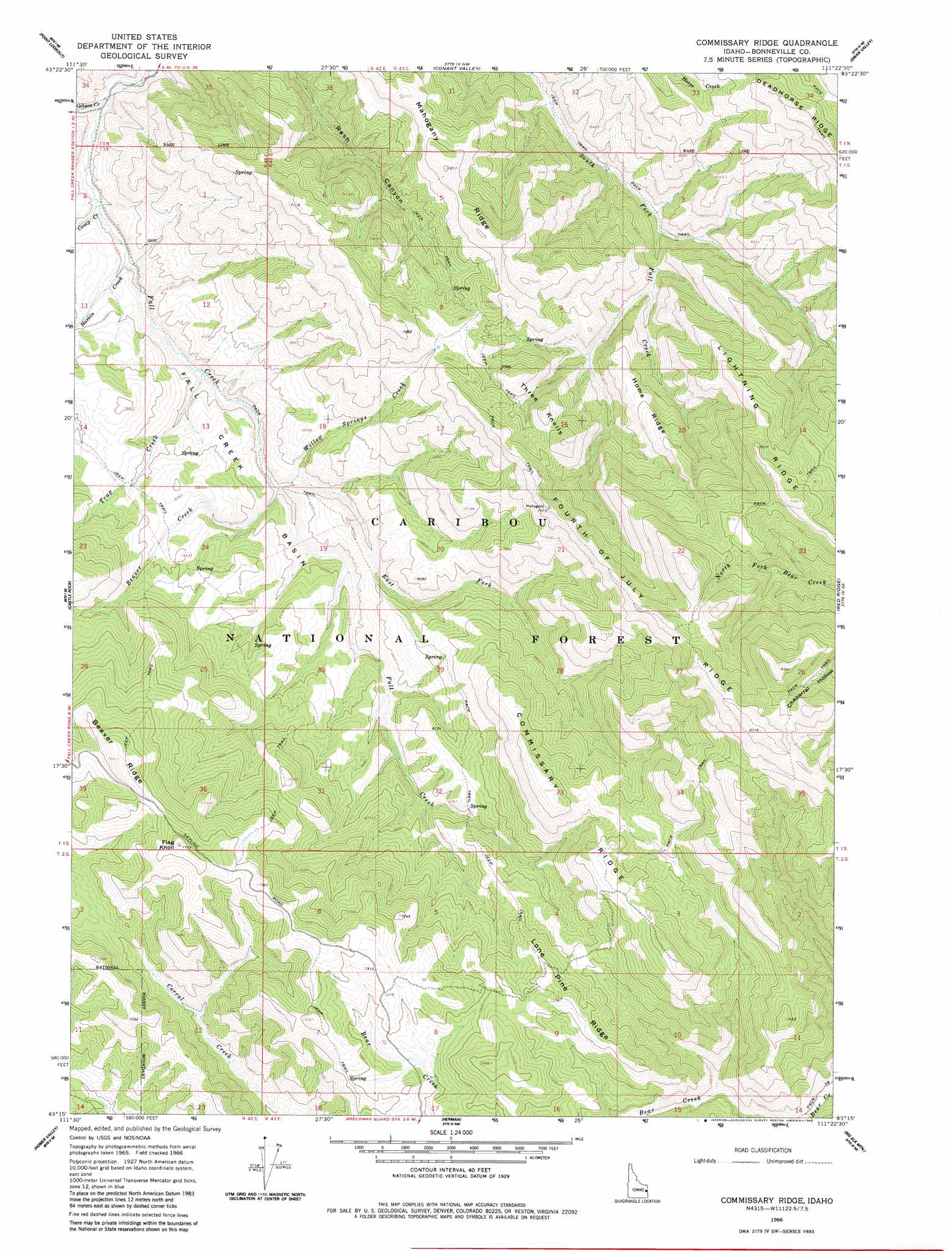
USGS Topo Quad 43111c4 - 1:24,000 scale
| Topo Map Name: | Commissary Ridge |
| USGS Topo Quad ID: | 43111c4 |
| Print Size: | ca. 21 1/4" wide x 27" high |
| Southeast Coordinates: | 43.25° N latitude / 111.375° W longitude |
| Map Center Coordinates: | 43.3125° N latitude / 111.4375° W longitude |
| U.S. State: | ID |
| Filename: | o43111c4.jpg |
| Download Map JPG Image: | Commissary Ridge topo map 1:24,000 scale |
| Map Type: | Topographic |
| Topo Series: | 7.5´ |
| Map Scale: | 1:24,000 |
| Source of Map Images: | United States Geological Survey (USGS) |
| Alternate Map Versions: |
Commissary Ridge ID 1966, updated 1969 Download PDF Buy paper map Commissary Ridge ID 1966, updated 1983 Download PDF Buy paper map Commissary Ridge ID 2011 Download PDF Buy paper map Commissary Ridge ID 2013 Download PDF Buy paper map |
| FStopo: | US Forest Service topo Commissary Ridge is available: Download FStopo PDF Download FStopo TIF |
1:24,000 Topo Quads surrounding Commissary Ridge
Poplar |
Heise Se |
Wheaton Mountain |
Stouts Mountain |
Fourth Of July Peak |
Lone Pine Ridge |
Point Lookout |
Conant Valley |
Swan Valley |
Thompson Peak |
Jumpoff Hill |
Castle Rock |
Commissary Ridge |
Red Ridge |
Palisades Dam |
Long Valley |
Homer Valley |
Herman |
Big Elk Mountain |
Poker Peak |
Meadow Creek Mountain |
Little Valley Hills |
Bear Island |
Caribou Mountain |
Tincup Mountain |
> Back to 43111a1 at 1:100,000 scale
> Back to 43110a1 at 1:250,000 scale
> Back to U.S. Topo Maps home
Commissary Ridge topo map: Gazetteer
Commissary Ridge: Basins
Fall Creek Basin elevation 1875m 6151′Commissary Ridge: Ridges
Beaver Ridge elevation 2309m 7575′Commissary Ridge elevation 2299m 7542′
Fourth of July Ridge elevation 2381m 7811′
Home Ridge elevation 2170m 7119′
Lightning Ridge elevation 2384m 7821′
Lone Pine Ridge elevation 2210m 7250′
Mahogany Ridge elevation 2076m 6811′
Mahogany Ridge elevation 2196m 7204′
Commissary Ridge: Streams
Beaver Creek elevation 1827m 5994′Camp Creek elevation 1753m 5751′
East Fork Fall Creek elevation 1826m 5990′
Gibson Creek elevation 1741m 5711′
Haskin Creek elevation 1765m 5790′
Trap Creek elevation 1786m 5859′
Willow Springs Creek elevation 1835m 6020′
Commissary Ridge: Summits
Flag Knoll elevation 2346m 7696′Three Knolls elevation 2217m 7273′
Commissary Ridge digital topo map on disk
Buy this Commissary Ridge topo map showing relief, roads, GPS coordinates and other geographical features, as a high-resolution digital map file on DVD: