Cow Lakes Topo Map Oregon
To zoom in, hover over the map of Cow Lakes
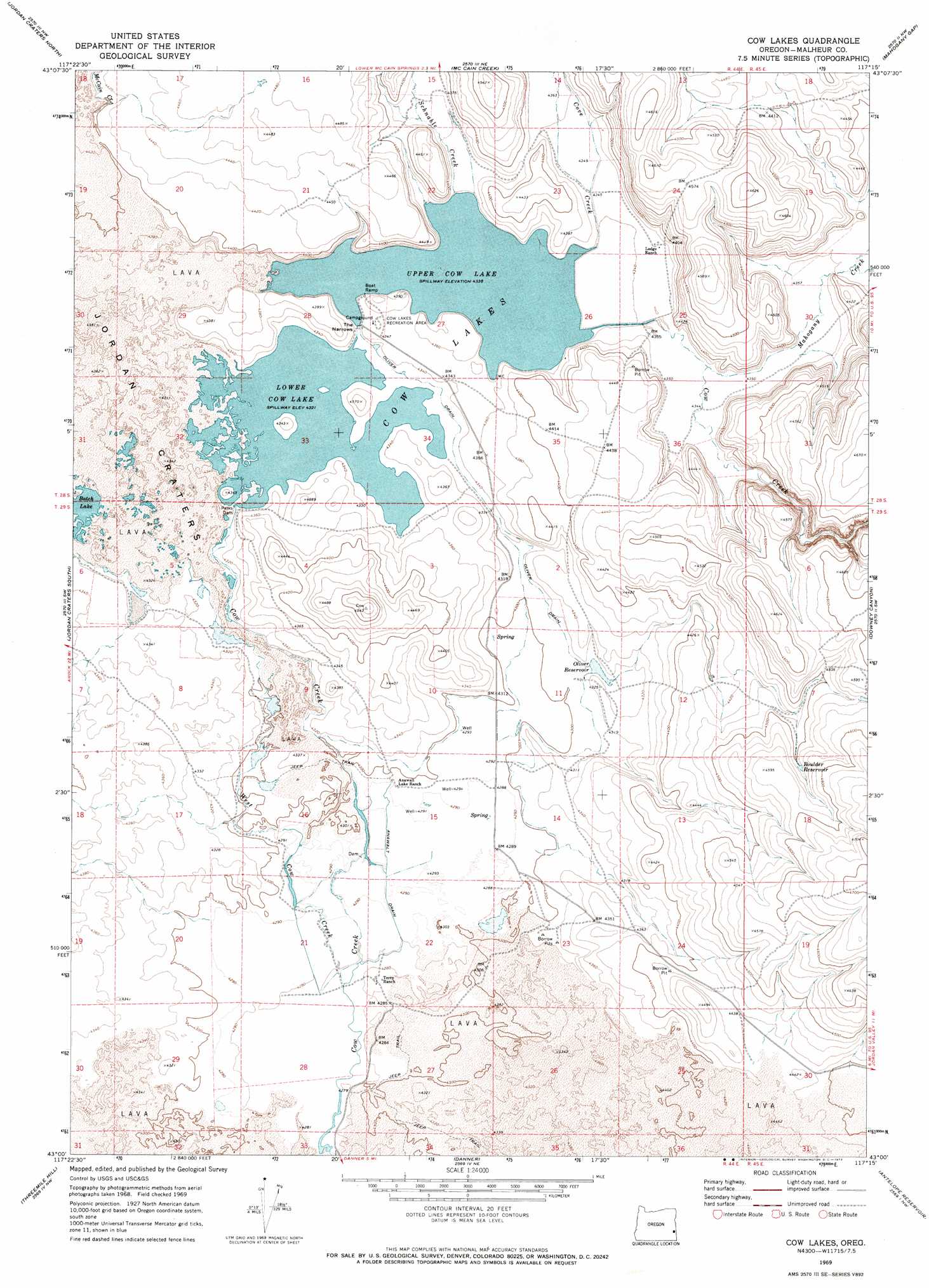
USGS Topo Quad 43117a3 - 1:24,000 scale
| Topo Map Name: | Cow Lakes |
| USGS Topo Quad ID: | 43117a3 |
| Print Size: | ca. 21 1/4" wide x 27" high |
| Southeast Coordinates: | 43° N latitude / 117.25° W longitude |
| Map Center Coordinates: | 43.0625° N latitude / 117.3125° W longitude |
| U.S. State: | OR |
| Filename: | o43117a3.jpg |
| Download Map JPG Image: | Cow Lakes topo map 1:24,000 scale |
| Map Type: | Topographic |
| Topo Series: | 7.5´ |
| Map Scale: | 1:24,000 |
| Source of Map Images: | United States Geological Survey (USGS) |
| Alternate Map Versions: |
Cow Lakes OR 1969, updated 1973 Download PDF Buy paper map Cow Lakes OR 2011 Download PDF Buy paper map Cow Lakes OR 2014 Download PDF Buy paper map |
1:24,000 Topo Quads surrounding Cow Lakes
Big Mud Flat |
Diamond Butte |
Rooster Comb |
Bannock Ridge |
Rockville |
The Hole In The Ground |
Jordan Craters North |
Mccain Creek |
Mahogany Gap |
Sheaville |
Bogus Bench |
Jordan Craters South |
Cow Lakes |
Downey Canyon |
Hooker Creek |
Arock |
Threemile Hill |
Danner |
Antelope Reservoir |
Jordan Valley |
Scott Reservoir |
Dry Creek Rim |
Little Grassy Mountain |
Juniper Ridge |
Parsnip Peak |
> Back to 43117a1 at 1:100,000 scale
> Back to 43116a1 at 1:250,000 scale
> Back to U.S. Topo Maps home
Cow Lakes topo map: Gazetteer
Cow Lakes: Canals
Anawalt Drain elevation 1309m 4294′Oliver Drain elevation 1316m 4317′
Cow Lakes: Dams
Parks Dam elevation 1318m 4324′Cow Lakes: Flats
Azcuenaga Meadows elevation 1313m 4307′Cow Lakes: Gaps
The Narrows elevation 1324m 4343′Cow Lakes: Lakes
Batch Lake elevation 1317m 4320′Lower Batch Lake elevation 1318m 4324′
Cow Lakes: Parks
Cow Lakes Recreation Area elevation 1327m 4353′Cow Lakes: Reservoirs
Angus Reservoir elevation 1351m 4432′Boulder Reservoir elevation 1378m 4520′
Cow Lakes elevation 1318m 4324′
Lower Cow Lake elevation 1318m 4324′
Oliver Reservoir elevation 1317m 4320′
Upper Cow Lake elevation 1324m 4343′
Cow Lakes: Springs
Hawkins Spring elevation 1311m 4301′Meadow Spring elevation 1309m 4294′
Cow Lakes: Streams
Cove Creek elevation 1324m 4343′East Cow Creek elevation 1318m 4324′
Mahogany Creek elevation 1325m 4347′
McCain Creek elevation 1325m 4347′
Schnable Creek elevation 1326m 4350′
West Cow Creek elevation 1306m 4284′
Cow Lakes digital topo map on disk
Buy this Cow Lakes topo map showing relief, roads, GPS coordinates and other geographical features, as a high-resolution digital map file on DVD: