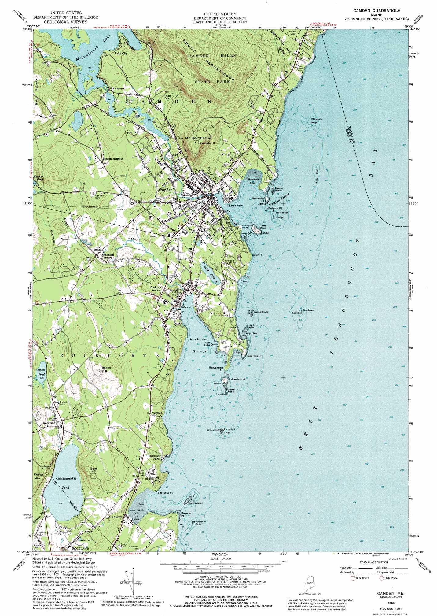
Camden Topo Map Maine
To zoom in, hover over the map of Camden
USGS Topo Quad 44069b1 - 1:24,000 scale
| Topo Map Name: | Camden |
| USGS Topo Quad ID: | 44069b1 |
| Print Size: | ca. 21 1/4" wide x 27" high |
| Southeast Coordinates: | 44.125° N latitude / 69° W longitude |
| Map Center Coordinates: | 44.1875° N latitude / 69.0625° W longitude |
| U.S. State: | ME |
| Filename: | o44069b1.jpg |
| Download Map JPG Image: | Camden topo map 1:24,000 scale |
| Map Type: | Topographic |
| Topo Series: | 7.5´ |
| Map Scale: | 1:24,000 |
| Source of Map Images: | United States Geological Survey (USGS) |
| Alternate Map Versions: |
Camden ME 1955, updated 1959 Download PDF Buy paper map Camden ME 1955, updated 1967 Download PDF Buy paper map Camden ME 1955, updated 1974 Download PDF Buy paper map Camden ME 1955, updated 1989 Download PDF Buy paper map Camden ME 1955, updated 1992 Download PDF Buy paper map Camden ME 2000, updated 2001 Download PDF Buy paper map Camden ME 2011 Download PDF Buy paper map Camden ME 2014 Download PDF Buy paper map |
1:24,000 Topo Quads surrounding Camden
Liberty |
Morrill |
Belfast |
Searsport |
Castine |
Washington |
Searsmont |
Lincolnville |
Islesboro |
Cape Rosier |
Union |
West Rockport |
Camden |
North Haven West |
North Haven East |
Waldoboro East |
Thomaston |
Rockland |
Leadbetter Island |
Vinalhaven |
Friendship |
Tenants Harbor |
Hewett Island |
> Back to 44069a1 at 1:100,000 scale
> Back to 44068a1 at 1:250,000 scale
> Back to U.S. Topo Maps home
Camden topo map: Gazetteer
Camden: Airports
Bald Mountain Airport elevation 166m 544′Penobscot Bay Medical Center Heliport elevation 48m 157′
Camden: Bars
Brewster Point Ledge elevation 0m 0′Brewster Point Ledge elevation 0m 0′
Dillingham Ledge elevation 0m 0′
Hog Cove Ledge elevation 0m 0′
Inner Ledges elevation 0m 0′
Kays Ledge elevation 0m 0′
Moxy Reef elevation 0m 0′
Northeast Ledge elevation 0m 0′
Outer Ledges elevation 0m 0′
Porterfield Ledge elevation 0m 0′
Seal Ledge elevation 0m 0′
The Graves elevation 0m 0′
Camden: Bays
Camden Harbor elevation 0m 0′Clam Cove elevation 0m 0′
Hog Cove elevation 0m 0′
Sherman Cove elevation 0m 0′
West Penobscot Bay elevation 0m 0′
Camden: Beaches
Laite Memorial Beach elevation 9m 29′Camden: Bridges
Tannery Lane Footbridge elevation 10m 32′Camden: Capes
Babcocks Point elevation 6m 19′Beauchamp Point elevation 8m 26′
Brewster Point elevation 0m 0′
Deadman Point elevation 6m 19′
Dillingham Point elevation 5m 16′
Eaton Point elevation 6m 19′
Northeast Point elevation 0m 0′
Ogier Point elevation 6m 19′
Camden: Channels
Northeast Passage elevation 0m 0′Camden: Dams
Chickawaukie Pond Dam elevation 37m 121′Knox Mill Dam elevation 10m 32′
Megunticook Lake East Dam elevation 43m 141′
Megunticook Lake West Dam elevation 43m 141′
Seabright Mill Dam elevation 36m 118′
Camden: Harbors
Rockport Harbor elevation 0m 0′Camden: Islands
Curtis Island elevation 8m 26′Goose Rock elevation 0m 0′
Indian Island elevation 8m 26′
Lowell Rock elevation 1m 3′
Mouse Island elevation 0m 0′
Ram Island elevation 4m 13′
Camden: Lakes
Lilly Pond elevation 29m 95′Maces Pond elevation 77m 252′
Megunticook Lake elevation 42m 137′
Camden: Parks
Camden Amphitheater elevation 6m 19′Camden Opera House Block elevation 17m 55′
Chestnut Street Historic District elevation 26m 85′
Cramer Park elevation 42m 137′
Curtis Island Park elevation 8m 26′
High Street Historic District elevation 40m 131′
Merryspring Park elevation 34m 111′
Rockport Historic District elevation 20m 65′
Rockport Marine Park elevation 2m 6′
Rockport Recreation Park elevation 61m 200′
Shirt Tail Point Park elevation 40m 131′
Village Green elevation 13m 42′
Walker Park elevation 1m 3′
Camden: Populated Places
Camden elevation 8m 26′Glen Cove elevation 15m 49′
Lake City elevation 49m 160′
Melvin Heights elevation 98m 321′
Rockport elevation 16m 52′
Rockville elevation 56m 183′
Simonton Corners elevation 29m 95′
Camden: Post Offices
Camden Post Office elevation 10m 32′Rockport Post Office elevation 39m 127′
Camden: Reservoirs
Chickawaukie Pond elevation 37m 121′Knox Mill Pond elevation 10m 32′
Seabright Pond elevation 54m 177′
Camden: Streams
Goose River elevation 2m 6′Great Brook elevation 0m 0′
Megunticook River elevation 1m 3′
Spring Brook elevation 0m 0′
Varnah Brook elevation 11m 36′
Camden: Summits
Bear Hill elevation 133m 436′Beech Hill elevation 159m 521′
Mount Battie elevation 240m 787′
Mount Megunticook elevation 419m 1374′
Pine Hill elevation 53m 173′
Camden: Trails
Maiden Cliff Trail elevation 18m 59′Mount Battie Trail elevation 238m 780′
Spring Brook Trail elevation 78m 255′
Camden digital topo map on disk
Buy this Camden topo map showing relief, roads, GPS coordinates and other geographical features, as a high-resolution digital map file on DVD:
Maine, New Hampshire, Rhode Island & Eastern Massachusetts
Buy digital topo maps: Maine, New Hampshire, Rhode Island & Eastern Massachusetts