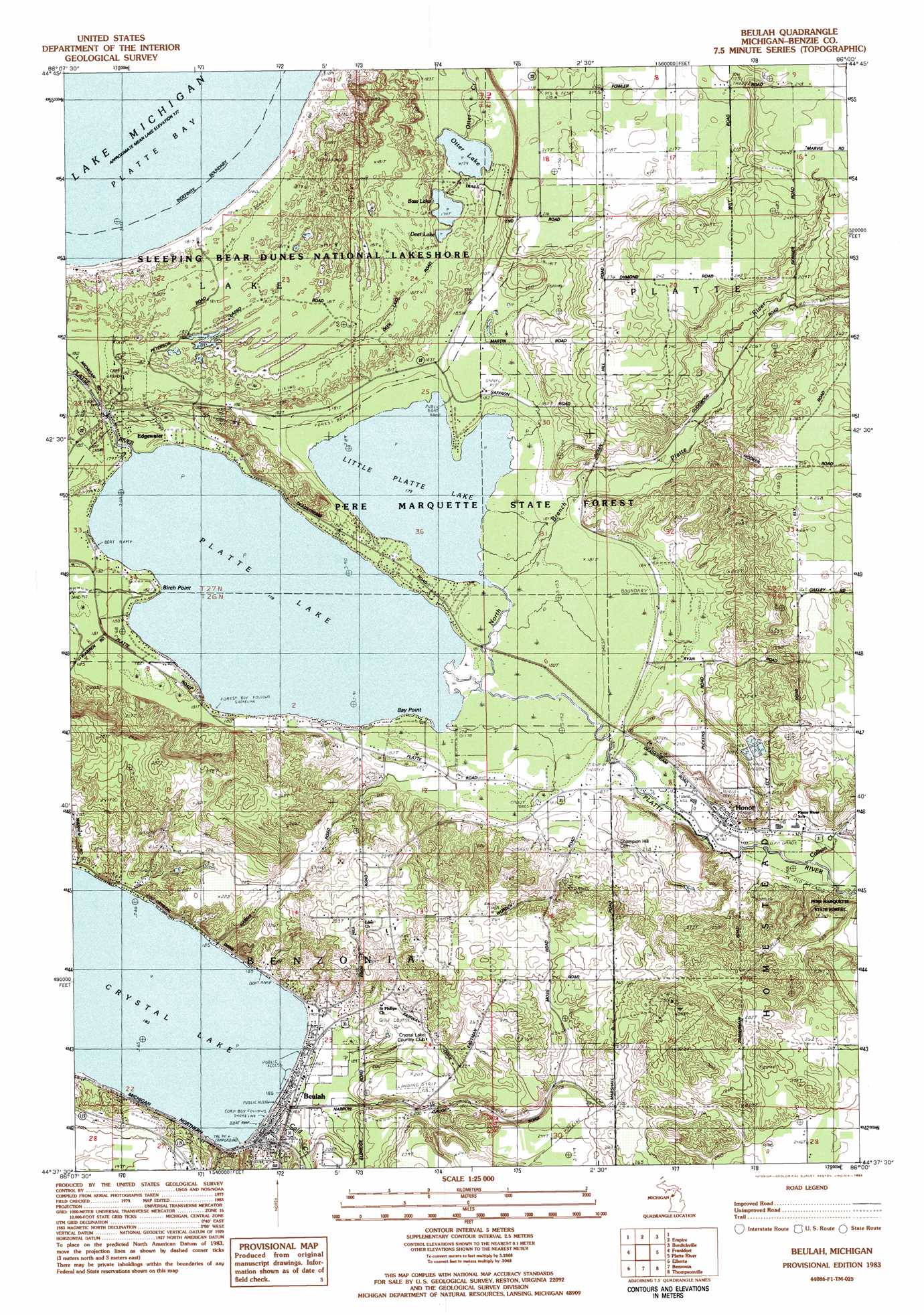
Beulah Topo Map Michigan
To zoom in, hover over the map of Beulah
USGS Topo Quad 44086f1 - 1:25,000 scale
| Topo Map Name: | Beulah |
| USGS Topo Quad ID: | 44086f1 |
| Print Size: | ca. 21 1/4" wide x 27" high |
| Southeast Coordinates: | 44.625° N latitude / 86° W longitude |
| Map Center Coordinates: | 44.6875° N latitude / 86.0625° W longitude |
| U.S. State: | MI |
| Filename: | l44086f1.jpg |
| Download Map JPG Image: | Beulah topo map 1:25,000 scale |
| Map Type: | Topographic |
| Topo Series: | 7.5´ |
| Map Scale: | 1:25,000 |
| Source of Map Images: | United States Geological Survey (USGS) |
| Alternate Map Versions: |
Beulah MI 1983, updated 1984 Download PDF Buy paper map |
1:24,000 Topo Quads surrounding Beulah
Glen Haven |
Glen Arbor |
Good Harbor Bay |
||
Empire |
Burdickville |
Maple City |
||
Frankfort |
Beulah |
Platte River |
Lake Ann |
|
Elberta |
Benzonia |
Thompsonville |
Karlin |
|
Bear Lake |
Pleasanton |
Copemish |
Harlan |
> Back to 44086e1 at 1:100,000 scale
> Back to 44086a1 at 1:250,000 scale
> Back to U.S. Topo Maps home
Beulah topo map: Gazetteer
Beulah: Bays
Platte Bay elevation 177m 580′Beulah: Beaches
Beulah Beach elevation 185m 606′Beulah: Capes
Bay Point elevation 179m 587′Birch Point elevation 178m 583′
Beulah: Lakes
Bass Lake elevation 177m 580′Deer Lake elevation 177m 580′
Little Platte Lake elevation 178m 583′
Otter Lake elevation 177m 580′
Platte Lake elevation 178m 583′
Beulah: Parks
Benzie State Park (historical) elevation 184m 603′Sleeping Bear Dunes National Lakeshore elevation 179m 587′
Trapp Farm Nature Preserve elevation 185m 606′
Beulah: Populated Places
Averytown (historical) elevation 180m 590′Beulah elevation 185m 606′
Edgewater elevation 182m 597′
Honor elevation 196m 643′
Beulah: Post Offices
Beulah Post Office elevation 185m 606′Edgewater Post Office (historical) elevation 181m 593′
Honor Post Office elevation 196m 643′
Stormer Post Office (historical) elevation 236m 774′
Beulah: Reservoirs
Honor Sewage Lagoons elevation 215m 705′Beulah: Streams
Cold Creek elevation 184m 603′Collison Creek elevation 190m 623′
Nichols Road Creek elevation 184m 603′
North Branch Platte River elevation 179m 587′
Beulah digital topo map on disk
Buy this Beulah topo map showing relief, roads, GPS coordinates and other geographical features, as a high-resolution digital map file on DVD: