Weston Topo Map Wyoming
To zoom in, hover over the map of Weston
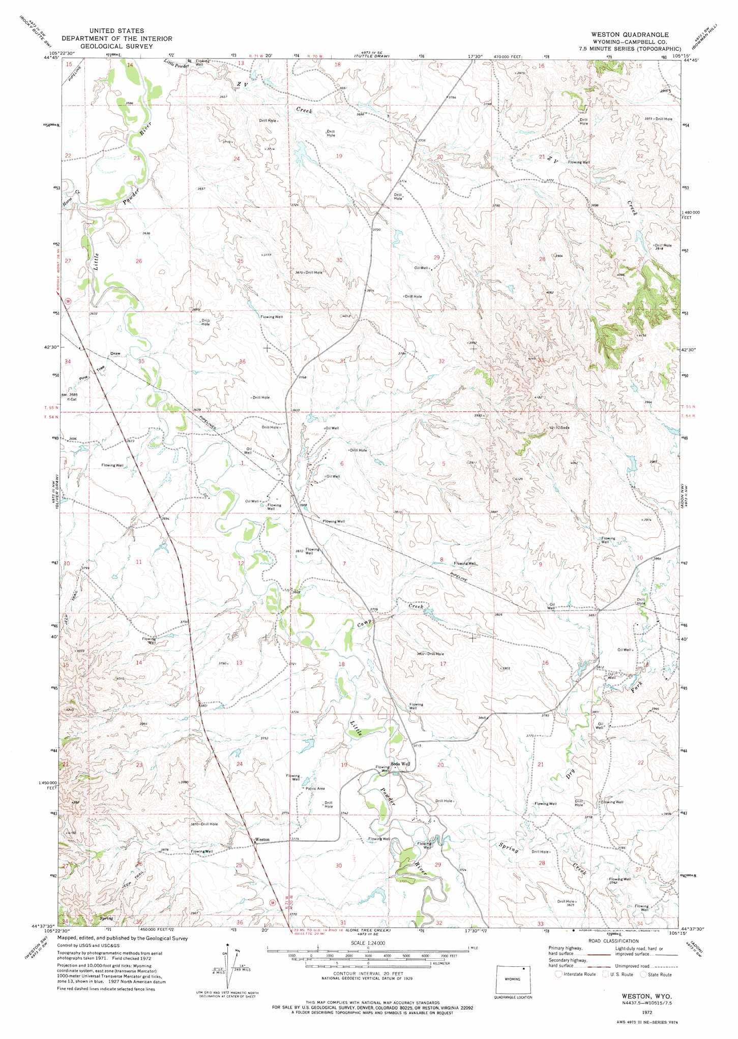
USGS Topo Quad 44105f3 - 1:24,000 scale
| Topo Map Name: | Weston |
| USGS Topo Quad ID: | 44105f3 |
| Print Size: | ca. 21 1/4" wide x 27" high |
| Southeast Coordinates: | 44.625° N latitude / 105.25° W longitude |
| Map Center Coordinates: | 44.6875° N latitude / 105.3125° W longitude |
| U.S. State: | WY |
| Filename: | o44105f3.jpg |
| Download Map JPG Image: | Weston topo map 1:24,000 scale |
| Map Type: | Topographic |
| Topo Series: | 7.5´ |
| Map Scale: | 1:24,000 |
| Source of Map Images: | United States Geological Survey (USGS) |
| Alternate Map Versions: |
Weston WY 1972, updated 1975 Download PDF Buy paper map Weston WY 2012 Download PDF Buy paper map Weston WY 2015 Download PDF Buy paper map |
| FStopo: | US Forest Service topo Weston is available: Download FStopo PDF Download FStopo TIF |
1:24,000 Topo Quads surrounding Weston
Homestead Draw |
Rocky Butte |
Nipple Butte |
Mitten Butte |
Rockypoint |
White Tail Butte |
Rocky Butte Sw |
Tuttle Draw |
Bowman Hill |
Bonnie Reservoir |
Pitch Draw |
Oliver Draw |
Weston |
Adon Nw |
Brislawn School |
Calf Creek |
Weston Sw |
Lone Tree Creek |
Adon |
Flag Butte |
Rawhide School |
Moyer Springs |
Green Hill |
Rozet Nw |
Rozet Ne |
> Back to 44105e1 at 1:100,000 scale
> Back to 44104a1 at 1:250,000 scale
> Back to U.S. Topo Maps home
Weston topo map: Gazetteer
Weston: Dams
Nettie Dam elevation 1121m 3677′Pippin Dam elevation 1135m 3723′
Snyder Homestead Dam elevation 1180m 3871′
Weston: Mines
Eveland Mine elevation 1123m 3684′Weston: Populated Places
Weston elevation 1159m 3802′Weston: Reservoirs
Nettie Reservoir elevation 1121m 3677′Pippin Reservoir elevation 1135m 3723′
Snyder Homestead Reservoir elevation 1180m 3871′
Weston: Streams
Camp Creek elevation 1116m 3661′Dry Fork Spring Creek elevation 1135m 3723′
Horse Creek elevation 1095m 3592′
Spring Creek elevation 1128m 3700′
Z V Creek elevation 1092m 3582′
Weston: Valleys
Pine Tree Draw elevation 1103m 3618′Weston: Wells
Soda Well elevation 1129m 3704′Weston digital topo map on disk
Buy this Weston topo map showing relief, roads, GPS coordinates and other geographical features, as a high-resolution digital map file on DVD:
Eastern Wyoming & Western South Dakota
Buy digital topo maps: Eastern Wyoming & Western South Dakota