Stone Mountain Topo Map Wyoming
To zoom in, hover over the map of Stone Mountain
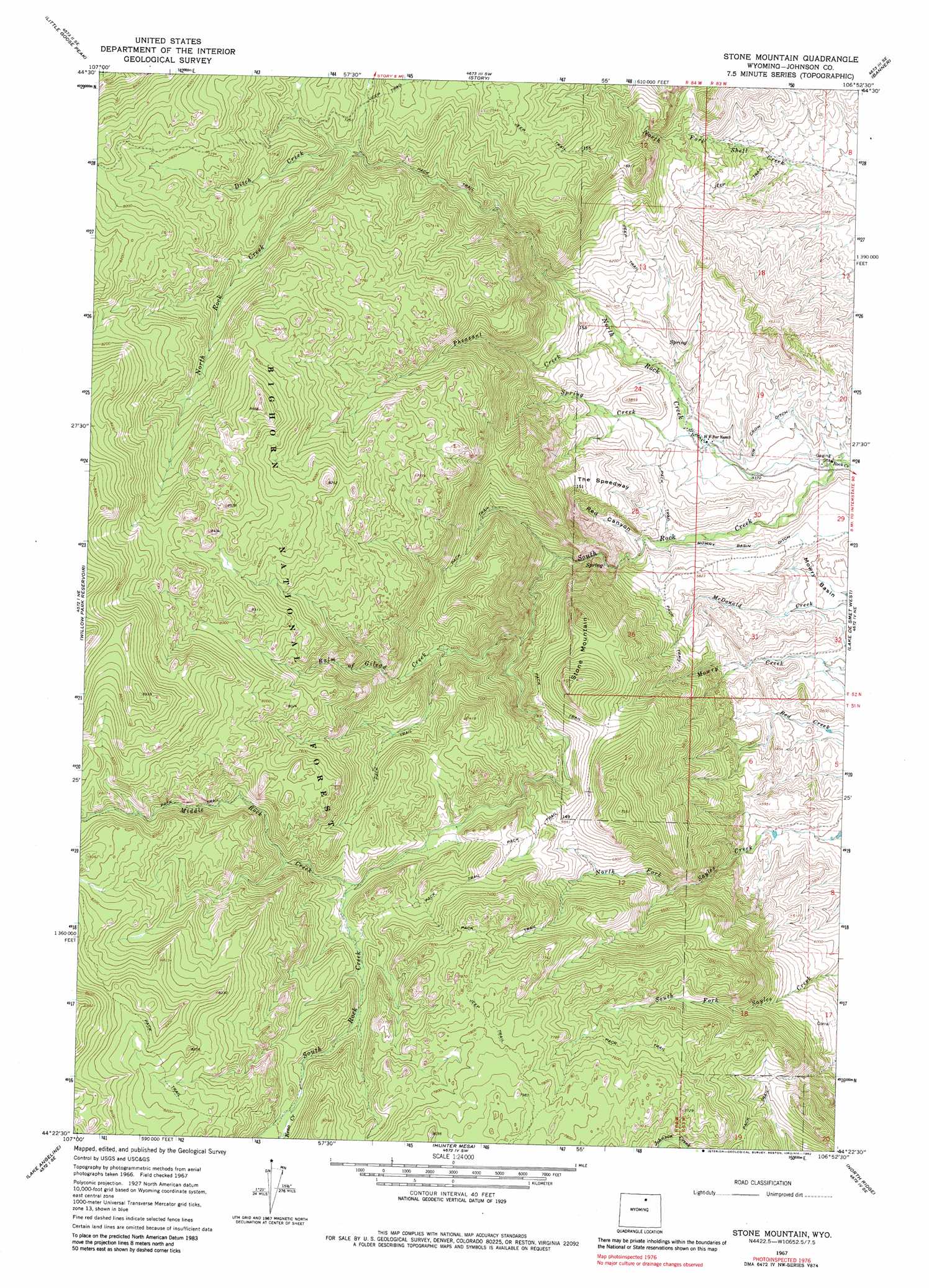
USGS Topo Quad 44106d8 - 1:24,000 scale
| Topo Map Name: | Stone Mountain |
| USGS Topo Quad ID: | 44106d8 |
| Print Size: | ca. 21 1/4" wide x 27" high |
| Southeast Coordinates: | 44.375° N latitude / 106.875° W longitude |
| Map Center Coordinates: | 44.4375° N latitude / 106.9375° W longitude |
| U.S. State: | WY |
| Filename: | o44106d8.jpg |
| Download Map JPG Image: | Stone Mountain topo map 1:24,000 scale |
| Map Type: | Topographic |
| Topo Series: | 7.5´ |
| Map Scale: | 1:24,000 |
| Source of Map Images: | United States Geological Survey (USGS) |
| Alternate Map Versions: |
Stone Mountain WY 1967, updated 1971 Download PDF Buy paper map Stone Mountain WY 1967, updated 1982 Download PDF Buy paper map Stone Mountain WY 1993, updated 1997 Download PDF Buy paper map Stone Mountain WY 2012 Download PDF Buy paper map Stone Mountain WY 2015 Download PDF Buy paper map |
| FStopo: | US Forest Service topo Stone Mountain is available: Download FStopo PDF Download FStopo TIF |
1:24,000 Topo Quads surrounding Stone Mountain
Beckton |
Beaver Creek Hills |
Big Horn |
Buffalo Run Creek |
Verona |
Park Reservoir |
Little Goose Peak |
Story |
Banner |
Horse Hill |
Cloud Peak |
Willow Park Reservoir |
Stone Mountain |
Lake De Smet West |
Lake De Smet East |
Lake Helen |
Lake Angeline |
Hunter Mesa |
North Ridge |
Buffalo |
Meadowlark Lake |
Powder River Pass |
Caribou Creek |
Klondike Ranch |
T A Ranch |
> Back to 44106a1 at 1:100,000 scale
> Back to 44106a1 at 1:250,000 scale
> Back to U.S. Topo Maps home
Stone Mountain topo map: Gazetteer
Stone Mountain: Canals
Jim Crow Ditch elevation 1663m 5456′Mowry Basin Ditch elevation 1702m 5583′
Stone Mountain: Mines
North Rock Creek Mine elevation 1890m 6200′Stone Mountain: Parks
Bud Love Big Game Winter Range elevation 1740m 5708′Stone Mountain: Populated Places
Saddlestring elevation 1658m 5439′Stone Mountain: Post Offices
Saddlestring Post Office (historical) elevation 1658m 5439′Stone Mountain: Streams
Balm of Gilead Creek elevation 1890m 6200′Ditch Creek elevation 2133m 6998′
Keno Creek elevation 2265m 7431′
Middle Rock Creek elevation 2135m 7004′
North Rock Creek elevation 1608m 5275′
Pheasant Creek elevation 1734m 5688′
South Rock Creek elevation 1609m 5278′
Spring Creek elevation 1669m 5475′
Stone Mountain: Summits
Stone Mountain elevation 2255m 7398′Stone Mountain: Valleys
Red Canyon elevation 1722m 5649′Stone Mountain digital topo map on disk
Buy this Stone Mountain topo map showing relief, roads, GPS coordinates and other geographical features, as a high-resolution digital map file on DVD:
Eastern Wyoming & Western South Dakota
Buy digital topo maps: Eastern Wyoming & Western South Dakota