Hunter Mesa Topo Map Wyoming
To zoom in, hover over the map of Hunter Mesa
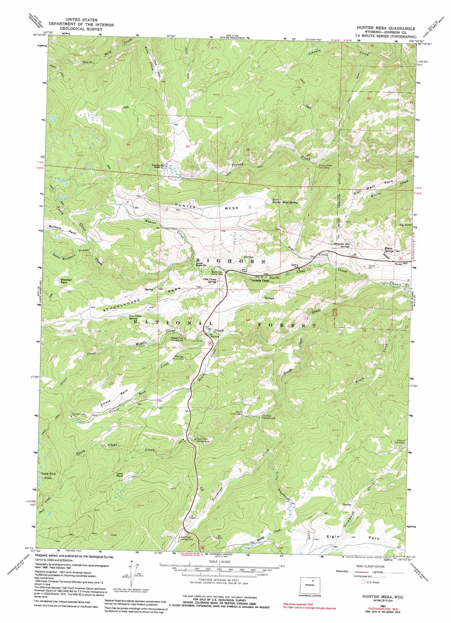
USGS Topo Quad 44106c8 - 1:24,000 scale
| Topo Map Name: | Hunter Mesa |
| USGS Topo Quad ID: | 44106c8 |
| Print Size: | ca. 21 1/4" wide x 27" high |
| Southeast Coordinates: | 44.25° N latitude / 106.875° W longitude |
| Map Center Coordinates: | 44.3125° N latitude / 106.9375° W longitude |
| U.S. State: | WY |
| Filename: | o44106c8.jpg |
| Download Map JPG Image: | Hunter Mesa topo map 1:24,000 scale |
| Map Type: | Topographic |
| Topo Series: | 7.5´ |
| Map Scale: | 1:24,000 |
| Source of Map Images: | United States Geological Survey (USGS) |
| Alternate Map Versions: |
Hunter Mesa WY 1967, updated 1971 Download PDF Buy paper map Hunter Mesa WY 1967, updated 1992 Download PDF Buy paper map Hunter Mesa WY 1993, updated 1997 Download PDF Buy paper map Hunter Mesa WY 2012 Download PDF Buy paper map Hunter Mesa WY 2015 Download PDF Buy paper map |
| FStopo: | US Forest Service topo Hunter Mesa is available: Download FStopo PDF Download FStopo TIF |
1:24,000 Topo Quads surrounding Hunter Mesa
Park Reservoir |
Little Goose Peak |
Story |
Banner |
Horse Hill |
Cloud Peak |
Willow Park Reservoir |
Stone Mountain |
Lake De Smet West |
Lake De Smet East |
Lake Helen |
Lake Angeline |
Hunter Mesa |
North Ridge |
Buffalo |
Meadowlark Lake |
Powder River Pass |
Caribou Creek |
Klondike Ranch |
T A Ranch |
Onion Gulch |
Hazelton Peak |
Hazelton |
Robinson Canyon |
Purdy Reservoir |
> Back to 44106a1 at 1:100,000 scale
> Back to 44106a1 at 1:250,000 scale
> Back to U.S. Topo Maps home
Hunter Mesa topo map: Gazetteer
Hunter Mesa: Flats
Buffalo Park elevation 2461m 8074′Circle Park elevation 2436m 7992′
Cull Watt Park elevation 2194m 7198′
Lynx Park elevation 2447m 8028′
Schoolhouse Park elevation 2336m 7664′
Webber Park elevation 2477m 8126′
Hunter Mesa: Springs
Cow Camp Spring elevation 2260m 7414′East Hunter Mesa Spring elevation 2376m 7795′
Fox Cabin Spring elevation 2405m 7890′
Hospital Hill Springs elevation 2170m 7119′
Mosier Springs elevation 2151m 7057′
Hunter Mesa: Streams
Circle Park Creek elevation 2243m 7358′Duck Creek elevation 2575m 8448′
Foot Creek elevation 2087m 6847′
Hondo Creek elevation 2228m 7309′
Hunter Creek elevation 2233m 7326′
Little Sourdough Creek elevation 2287m 7503′
Middle Clear Creek elevation 2105m 6906′
North Clear Creek elevation 2046m 6712′
Oliver Creek elevation 2384m 7821′
Rabbit Creek elevation 2397m 7864′
Seven Brothers Creek elevation 2375m 7791′
Sourdough Creek elevation 2249m 7378′
South Clear Creek elevation 2046m 6712′
Hunter Mesa: Summits
Hunter Mesa elevation 2426m 7959′Hunter Mesa digital topo map on disk
Buy this Hunter Mesa topo map showing relief, roads, GPS coordinates and other geographical features, as a high-resolution digital map file on DVD:
Eastern Wyoming & Western South Dakota
Buy digital topo maps: Eastern Wyoming & Western South Dakota