Shell Falls Topo Map Wyoming
To zoom in, hover over the map of Shell Falls
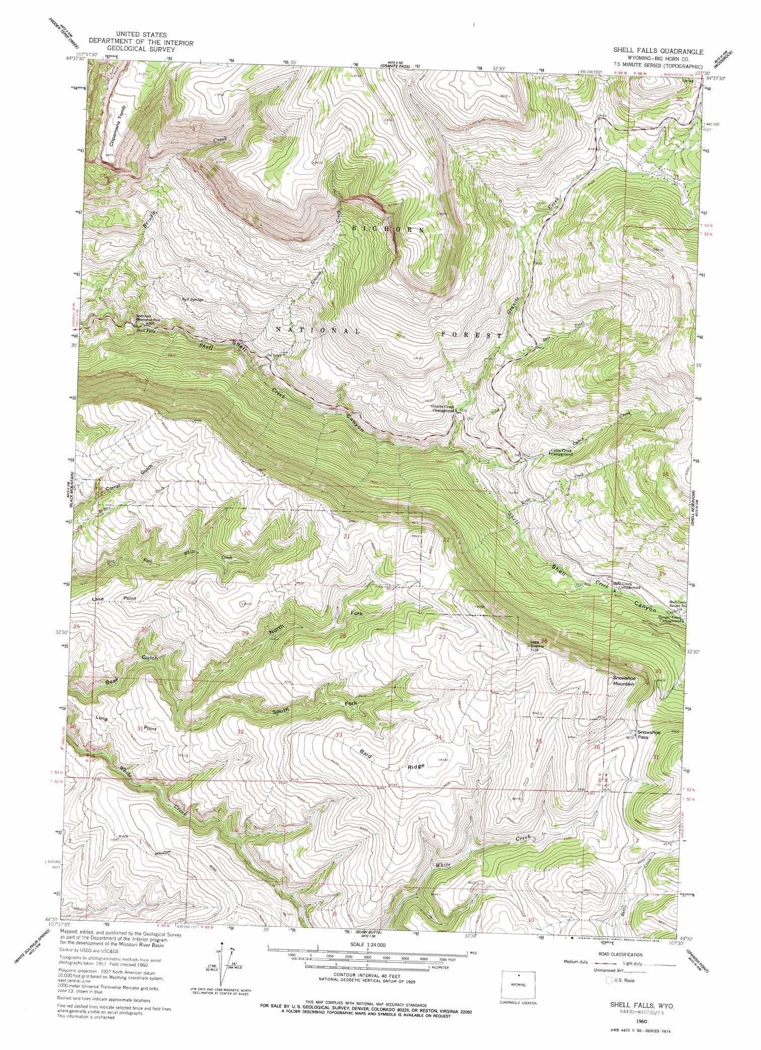
USGS Topo Quad 44107e5 - 1:24,000 scale
| Topo Map Name: | Shell Falls |
| USGS Topo Quad ID: | 44107e5 |
| Print Size: | ca. 21 1/4" wide x 27" high |
| Southeast Coordinates: | 44.5° N latitude / 107.5° W longitude |
| Map Center Coordinates: | 44.5625° N latitude / 107.5625° W longitude |
| U.S. State: | WY |
| Filename: | o44107e5.jpg |
| Download Map JPG Image: | Shell Falls topo map 1:24,000 scale |
| Map Type: | Topographic |
| Topo Series: | 7.5´ |
| Map Scale: | 1:24,000 |
| Source of Map Images: | United States Geological Survey (USGS) |
| Alternate Map Versions: |
Shell Falls WY 1960, updated 1962 Download PDF Buy paper map Shell Falls WY 1960, updated 1978 Download PDF Buy paper map Shell Falls WY 1993, updated 1997 Download PDF Buy paper map Shell Falls WY 2012 Download PDF Buy paper map Shell Falls WY 2015 Download PDF Buy paper map |
| FStopo: | US Forest Service topo Shell Falls is available: Download FStopo PDF Download FStopo TIF |
1:24,000 Topo Quads surrounding Shell Falls
Bald Mountain |
Ice Creek |
Burgess Junction |
Skull Ridge |
Dayton South |
Leavitt Reservoir |
Hidden Tepee Creek |
Granite Pass |
Woodrock |
Walker Mountain |
Shell |
Black Mountain |
Shell Falls |
Shell Reservoir |
Dome Lake |
Manderson Ne |
White Sulphur Spring |
Bush Butte |
Spanish Point |
Shell Lake |
Manderson Se |
Flitner Reservoir |
Hyatt Ranch |
Allen Draw |
Lake Solitude |
> Back to 44107e1 at 1:100,000 scale
> Back to 44106a1 at 1:250,000 scale
> Back to U.S. Topo Maps home
Shell Falls topo map: Gazetteer
Shell Falls: Canals
Whaley Ditch elevation 2644m 8674′Shell Falls: Capes
Long Point elevation 2256m 7401′Shell Falls: Falls
Shell Falls elevation 1907m 6256′Shell Falls: Gaps
Snowshoe Pass elevation 2637m 8651′Shell Falls: Ridges
Bald Ridge elevation 2620m 8595′Copmans Tomb elevation 2705m 8874′
Lake Point elevation 2369m 7772′
Shell Falls: Springs
Bull Springs elevation 2063m 6768′Shell Falls: Streams
Brindle Creek elevation 1836m 6023′Cabin Creek elevation 2146m 7040′
Cry Creek elevation 2193m 7194′
Dry Fork Granite Creek elevation 2453m 8047′
Granite Creek elevation 2125m 6971′
Grouse Creek elevation 2026m 6646′
Ranger Creek elevation 2335m 7660′
Ruble Creek elevation 2196m 7204′
Salt Creek elevation 2329m 7641′
Shell Falls: Summits
Snowshoe Mountain elevation 2808m 9212′Shell Falls: Trails
Bench Trail elevation 2238m 7342′Shell Falls: Valleys
North Fork Bear Gulch elevation 2255m 7398′South Fork Bear Gulch elevation 2249m 7378′
Shell Falls digital topo map on disk
Buy this Shell Falls topo map showing relief, roads, GPS coordinates and other geographical features, as a high-resolution digital map file on DVD:
Eastern Wyoming & Western South Dakota
Buy digital topo maps: Eastern Wyoming & Western South Dakota