Brookton Topo Map Maine
To zoom in, hover over the map of Brookton
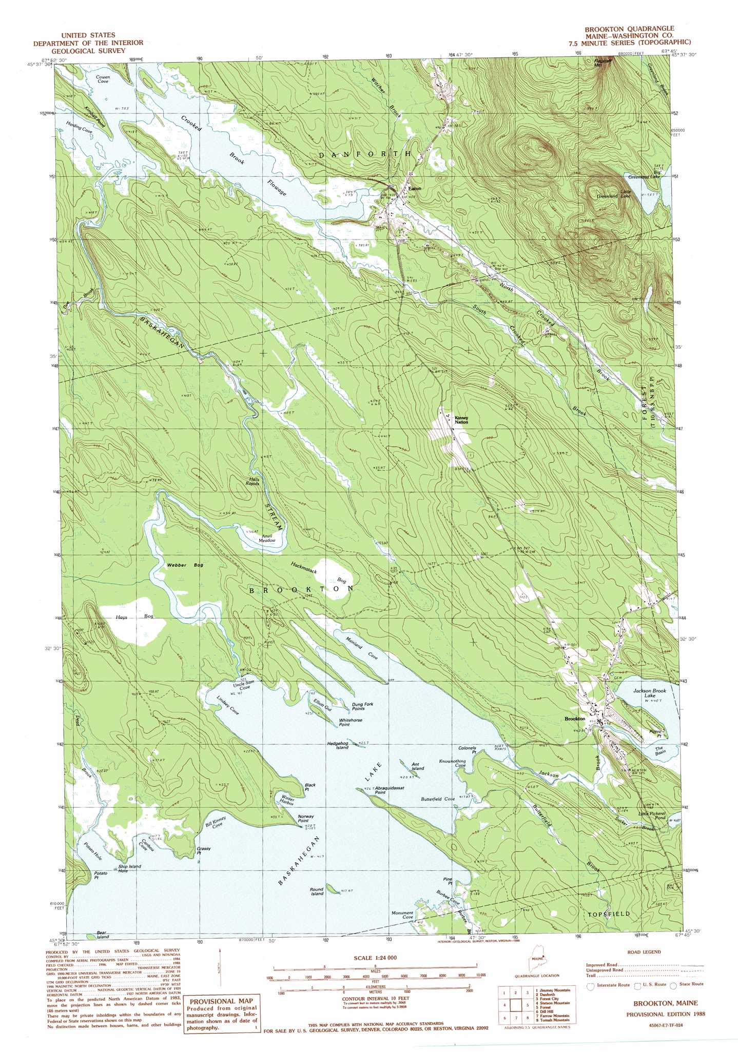
USGS Topo Quad 45067e7 - 1:24,000 scale
| Topo Map Name: | Brookton |
| USGS Topo Quad ID: | 45067e7 |
| Print Size: | ca. 21 1/4" wide x 27" high |
| Southeast Coordinates: | 45.5° N latitude / 67.75° W longitude |
| Map Center Coordinates: | 45.5625° N latitude / 67.8125° W longitude |
| U.S. State: | ME |
| Filename: | o45067e7.jpg |
| Download Map JPG Image: | Brookton topo map 1:24,000 scale |
| Map Type: | Topographic |
| Topo Series: | 7.5´ |
| Map Scale: | 1:24,000 |
| Source of Map Images: | United States Geological Survey (USGS) |
| Alternate Map Versions: |
Danforth SE ME 1975, updated 1980 Download PDF Buy paper map Brookton ME 1988, updated 1988 Download PDF Buy paper map Brookton ME 2011 Download PDF Buy paper map Brookton ME 2014 Download PDF Buy paper map |
1:24,000 Topo Quads surrounding Brookton
Alder Brook |
Haynesville |
Orient |
||
Wytopitlock |
Jimmey Mountain |
Danforth |
Forest City |
|
Potter Hill |
Stetson Mountain |
Brookton |
Forest |
Lambert Lake |
Bowers Mountain |
Dill Hill |
Farrow Mountain |
Tomah Mountain |
Simsquish Lake |
Bottle Lake |
Scraggly Lake |
Oxbrook Lakes |
Waite |
Toman Ridge |
> Back to 45067e1 at 1:100,000 scale
> Back to 45066a1 at 1:250,000 scale
> Back to U.S. Topo Maps home
Brookton topo map: Gazetteer
Brookton: Bays
Bill Kinney Cove elevation 127m 416′Burbee Cove elevation 127m 416′
Butterfield Cove elevation 127m 416′
Caribou Cove elevation 127m 416′
Cowen Cove elevation 117m 383′
Harding Cove elevation 117m 383′
Knownothing Cove elevation 129m 423′
Lindsey Cove elevation 127m 416′
Mainland Cove elevation 127m 416′
Monument Cove elevation 127m 416′
Potato Hole elevation 127m 416′
Uncle Sam Cove elevation 127m 416′
Winter Harbor elevation 127m 416′
Brookton: Capes
Abraquidassat Point elevation 127m 416′Black Point elevation 127m 416′
Colonels Point elevation 129m 423′
Dung Fork Points elevation 127m 416′
Grassy Point elevation 127m 416′
Kimball Point elevation 118m 387′
Norway Point elevation 127m 416′
Picnic Point elevation 135m 442′
Pine Point elevation 129m 423′
Potato Point elevation 128m 419′
Whitehorse Point elevation 127m 416′
Brookton: Guts
Elliott Gut elevation 127m 416′Brookton: Islands
Ant Island elevation 127m 416′Bear Island elevation 127m 416′
Hedgehog Island elevation 127m 416′
Round Island elevation 127m 416′
Ship Island Hole elevation 127m 416′
Brookton: Lakes
Baskahegan Lake elevation 127m 416′Crooked Brook Flowage elevation 117m 383′
Little Greenland Lake elevation 177m 580′
The Basin elevation 134m 439′
Brookton: Populated Places
Brookton elevation 137m 449′Eaton elevation 123m 403′
Brookton: Rapids
Hell Rapids elevation 130m 426′Brookton: Streams
Burbee Brook elevation 128m 419′Butterfield Brook elevation 127m 416′
Dead Brook elevation 128m 419′
Doe Brook elevation 119m 390′
Jackson Brook elevation 127m 416′
North Crooked Brook elevation 117m 383′
South Crooked Brook elevation 123m 403′
Sucker Brook elevation 134m 439′
Witcher Brook elevation 118m 387′
Brookton: Swamps
Anvil Meadow elevation 127m 416′Hackmatack Bog elevation 129m 423′
Hays Bog elevation 127m 416′
Webber Bog elevation 127m 416′
Brookton digital topo map on disk
Buy this Brookton topo map showing relief, roads, GPS coordinates and other geographical features, as a high-resolution digital map file on DVD:
Maine, New Hampshire, Rhode Island & Eastern Massachusetts
Buy digital topo maps: Maine, New Hampshire, Rhode Island & Eastern Massachusetts