Salmon Stream Lake Topo Map Maine
To zoom in, hover over the map of Salmon Stream Lake
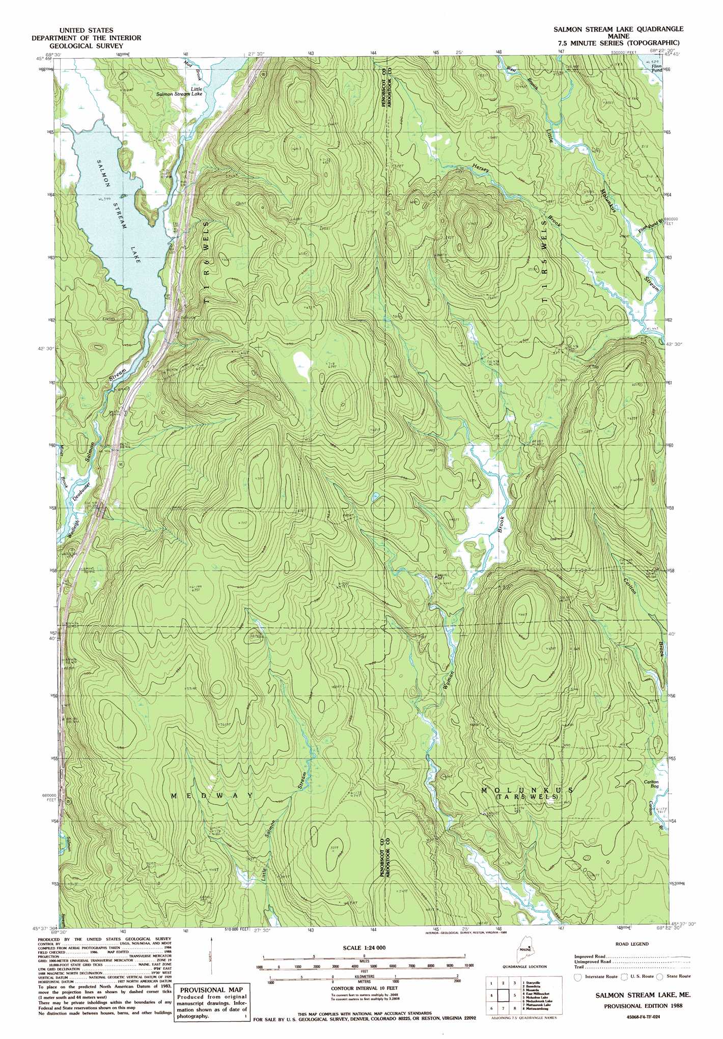
USGS Topo Quad 45068f4 - 1:24,000 scale
| Topo Map Name: | Salmon Stream Lake |
| USGS Topo Quad ID: | 45068f4 |
| Print Size: | ca. 21 1/4" wide x 27" high |
| Southeast Coordinates: | 45.625° N latitude / 68.375° W longitude |
| Map Center Coordinates: | 45.6875° N latitude / 68.4375° W longitude |
| U.S. State: | ME |
| Filename: | o45068f4.jpg |
| Download Map JPG Image: | Salmon Stream Lake topo map 1:24,000 scale |
| Map Type: | Topographic |
| Topo Series: | 7.5´ |
| Map Scale: | 1:24,000 |
| Source of Map Images: | United States Geological Survey (USGS) |
| Alternate Map Versions: |
Mattawamkeag NW ME 1975, updated 1980 Download PDF Buy paper map Salmon Stream Lake ME 1988, updated 1988 Download PDF Buy paper map Salmon Stream Lake ME 2011 Download PDF Buy paper map Salmon Stream Lake ME 2014 Download PDF Buy paper map |
1:24,000 Topo Quads surrounding Salmon Stream Lake
Deasey Mountain |
Lookout Mountain |
Patten |
Crystal |
Mattawamkeag Lake |
Whetstone Mountain |
Stacyville |
Benedicta |
Monarda |
Wytopitlock Lake |
Millinocket |
East Millinocket |
Salmon Stream Lake |
Molunkid Lake |
Reed Pond |
Nollesemic Lake |
Medunkeunk Lake |
Mattaseunk Lake |
Mattawamkeag |
Kingman |
Mattamiscontis Mountain |
Nine Meadow Ridge |
Lincoln Center |
East Winn |
Springfield |
> Back to 45068e1 at 1:100,000 scale
> Back to 45068a1 at 1:250,000 scale
> Back to U.S. Topo Maps home
Salmon Stream Lake topo map: Gazetteer
Salmon Stream Lake: Reservoirs
Salmon Stream Lake elevation 121m 396′Salmon Stream Lake: Streams
Flinn Pond Brook elevation 135m 442′Hersey Brook elevation 135m 442′
Miner Brook elevation 112m 367′
Mud Brook elevation 124m 406′
West Branch Little Molunkus Stream elevation 140m 459′
Salmon Stream Lake digital topo map on disk
Buy this Salmon Stream Lake topo map showing relief, roads, GPS coordinates and other geographical features, as a high-resolution digital map file on DVD:
Maine, New Hampshire, Rhode Island & Eastern Massachusetts
Buy digital topo maps: Maine, New Hampshire, Rhode Island & Eastern Massachusetts