Spencer Bay Topo Map Maine
To zoom in, hover over the map of Spencer Bay
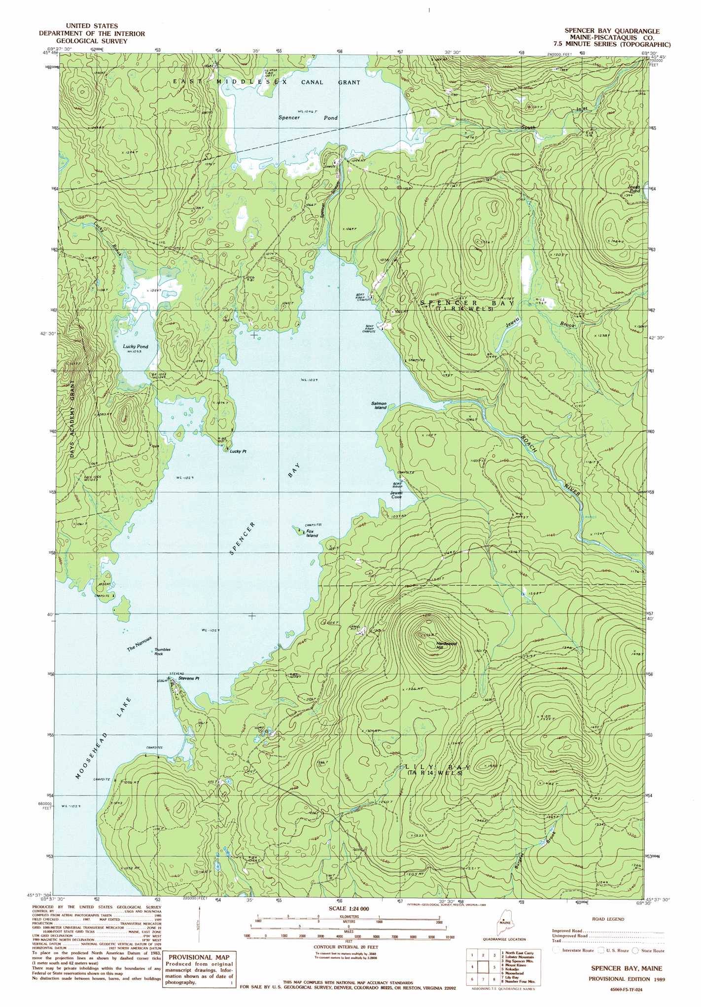
USGS Topo Quad 45069f5 - 1:24,000 scale
| Topo Map Name: | Spencer Bay |
| USGS Topo Quad ID: | 45069f5 |
| Print Size: | ca. 21 1/4" wide x 27" high |
| Southeast Coordinates: | 45.625° N latitude / 69.5° W longitude |
| Map Center Coordinates: | 45.6875° N latitude / 69.5625° W longitude |
| U.S. State: | ME |
| Filename: | o45069f5.jpg |
| Download Map JPG Image: | Spencer Bay topo map 1:24,000 scale |
| Map Type: | Topographic |
| Topo Series: | 7.5´ |
| Map Scale: | 1:24,000 |
| Source of Map Images: | United States Geological Survey (USGS) |
| Alternate Map Versions: |
Spencer Bay ME 1977, updated 1981 Download PDF Buy paper map Spencer Bay ME 1989, updated 1989 Download PDF Buy paper map Spencer Bay ME 2011 Download PDF Buy paper map Spencer Bay ME 2014 Download PDF Buy paper map |
1:24,000 Topo Quads surrounding Spencer Bay
Seboomook Lake East |
Seboomook |
Penobscot Farm |
Pine Stream Flowage |
Caribou Lake North |
Socatean Bay |
North East Carry |
Lobster Mountain |
Big Spencer Mountain |
Caribou Lake South |
Brassua Lake East |
Mount Kineo |
Spencer Bay |
Kokadjo |
Farrar Mountain |
Indian Pond North |
Moosehead |
Lily Bay |
Number Four Mountain |
Hay Mountain |
Indian Pond South |
Big Squaw Pond |
Greenville |
Barren Mountain West |
Barren Mountain East |
> Back to 45069e1 at 1:100,000 scale
> Back to 45068a1 at 1:250,000 scale
> Back to U.S. Topo Maps home
Spencer Bay topo map: Gazetteer
Spencer Bay: Bays
Jewett Cove elevation 313m 1026′Spencer Bay elevation 313m 1026′
Spencer Bay: Capes
Case Point elevation 316m 1036′Lucky Point elevation 313m 1026′
Stevens Point elevation 317m 1040′
Spencer Bay: Channels
The Narrows elevation 313m 1026′Spencer Bay: Dams
Lucky Pond Dam elevation 320m 1049′Spencer Pond Dam elevation 319m 1046′
Spencer Bay: Islands
Fox Island elevation 314m 1030′Mallars Island elevation 313m 1026′
Salmon Island elevation 314m 1030′
Togue Island elevation 313m 1026′
Trumbles Rock elevation 313m 1026′
Spencer Bay: Reservoirs
Lucky Pond elevation 320m 1049′Spencer Pond elevation 319m 1046′
Spencer Bay: Streams
Jewett Brook elevation 317m 1040′Lucky Brook elevation 321m 1053′
Roach River elevation 313m 1026′
South Inlet elevation 319m 1046′
Spencer Stream elevation 313m 1026′
Spencer Bay: Summits
Hardwood Hill elevation 476m 1561′Spencer Bay digital topo map on disk
Buy this Spencer Bay topo map showing relief, roads, GPS coordinates and other geographical features, as a high-resolution digital map file on DVD:
Maine, New Hampshire, Rhode Island & Eastern Massachusetts
Buy digital topo maps: Maine, New Hampshire, Rhode Island & Eastern Massachusetts