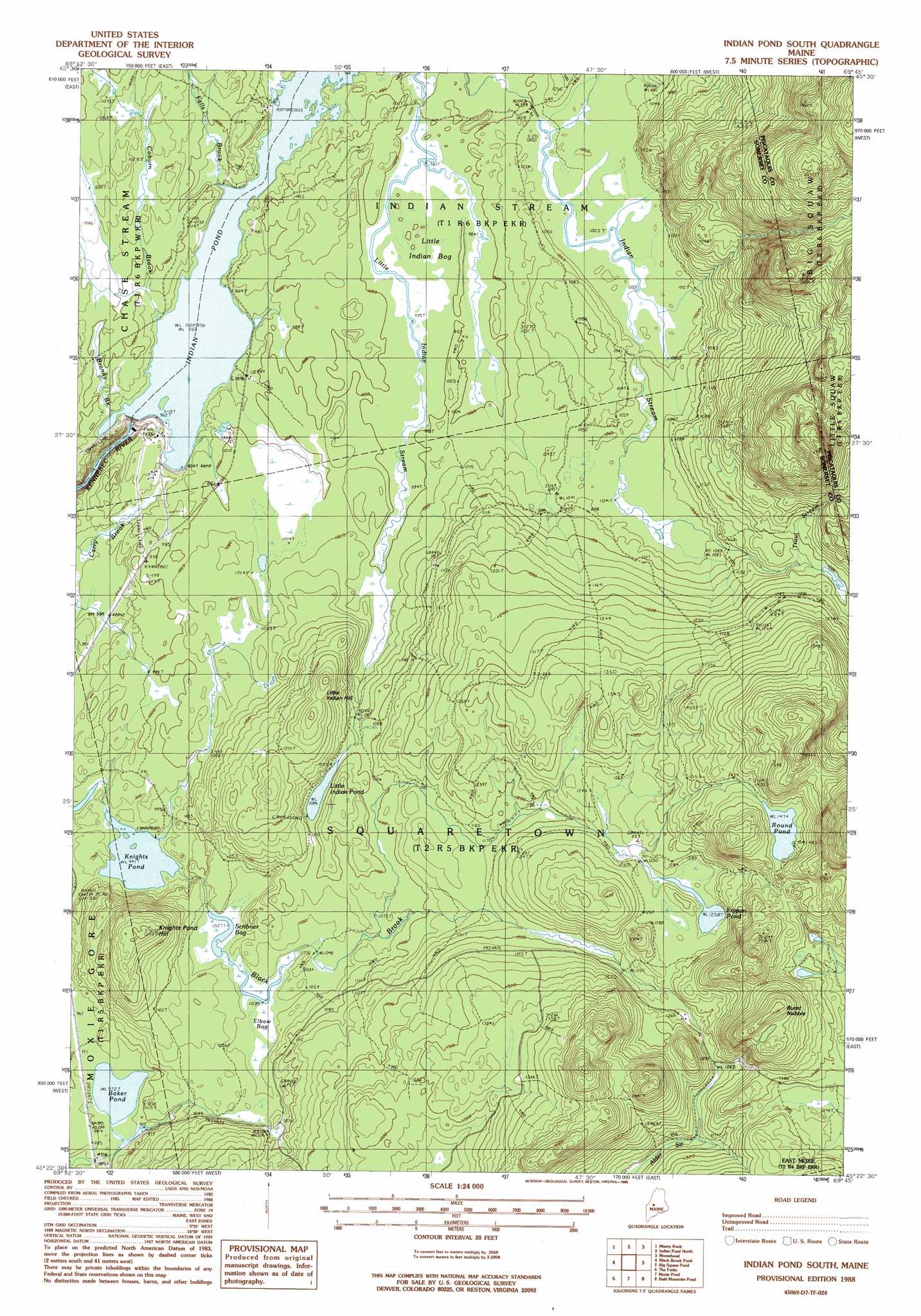
Indian Pond South Topo Map Maine
To zoom in, hover over the map of Indian Pond South
USGS Topo Quad 45069d7 - 1:24,000 scale
| Topo Map Name: | Indian Pond South |
| USGS Topo Quad ID: | 45069d7 |
| Print Size: | ca. 21 1/4" wide x 27" high |
| Southeast Coordinates: | 45.375° N latitude / 69.75° W longitude |
| Map Center Coordinates: | 45.4375° N latitude / 69.8125° W longitude |
| U.S. State: | ME |
| Filename: | o45069d7.jpg |
| Download Map JPG Image: | Indian Pond South topo map 1:24,000 scale |
| Map Type: | Topographic |
| Topo Series: | 7.5´ |
| Map Scale: | 1:24,000 |
| Source of Map Images: | United States Geological Survey (USGS) |
| Alternate Map Versions: |
Indian Pond South ME 1977, updated 1981 Download PDF Buy paper map Indian Pond South ME 1988, updated 1988 Download PDF Buy paper map Indian Pond South ME 2011 Download PDF Buy paper map Indian Pond South ME 2014 Download PDF Buy paper map |
1:24,000 Topo Quads surrounding Indian Pond South
Churchill Stream |
Brassua Lake West |
Brassua Lake East |
Mount Kineo |
Spencer Bay |
Long Pond |
Misery Knob |
Indian Pond North |
Moosehead |
Lily Bay |
Johnson Mountain |
Black Brook Pond |
Indian Pond South |
Big Squaw Pond |
Greenville |
Pierce Pond |
The Forks |
Moxie Pond |
Bald Mountain Pond |
Monson West |
East Carry Pond |
Caratunk |
Dimmick Mountain |
Foster Ridge |
Whetstone Pond |
> Back to 45069a1 at 1:100,000 scale
> Back to 45068a1 at 1:250,000 scale
> Back to U.S. Topo Maps home
Indian Pond South topo map: Gazetteer
Indian Pond South: Dams
Harris Dam elevation 290m 951′Harris Dike elevation 293m 961′
Indian Pond South: Lakes
Baker Pond elevation 296m 971′Frypan Pond elevation 383m 1256′
Knights Pond elevation 287m 941′
Little Indian Pond elevation 330m 1082′
Round Pond elevation 449m 1473′
Indian Pond South: Reservoirs
Indian Pond elevation 290m 951′Indian Pond South: Streams
Alder Stream elevation 362m 1187′Brandy Brook elevation 292m 958′
Coburn Brook elevation 292m 958′
Falls Brook elevation 291m 954′
Trout Stream elevation 354m 1161′
Indian Pond South: Summits
Burnt Nubble elevation 519m 1702′Knights Pond Hill elevation 397m 1302′
Little Indian Hill elevation 398m 1305′
Indian Pond South: Swamps
Elbow Bog elevation 316m 1036′Little Indian Bog elevation 302m 990′
Scribner Bog elevation 313m 1026′
Indian Pond South digital topo map on disk
Buy this Indian Pond South topo map showing relief, roads, GPS coordinates and other geographical features, as a high-resolution digital map file on DVD:
Maine, New Hampshire, Rhode Island & Eastern Massachusetts
Buy digital topo maps: Maine, New Hampshire, Rhode Island & Eastern Massachusetts