Mckenzie Lake Topo Map Wisconsin
To zoom in, hover over the map of Mckenzie Lake
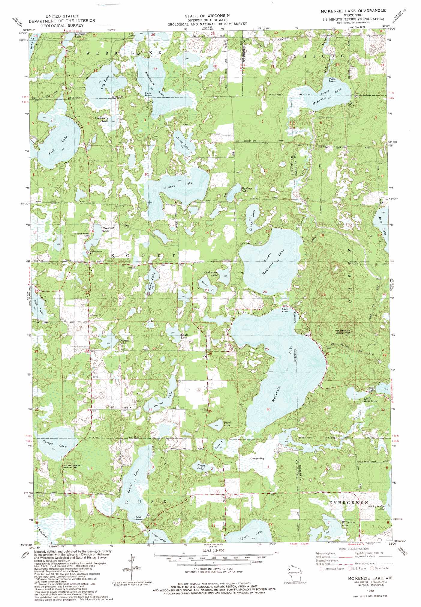
USGS Topo Quad 45092h1 - 1:24,000 scale
| Topo Map Name: | Mckenzie Lake |
| USGS Topo Quad ID: | 45092h1 |
| Print Size: | ca. 21 1/4" wide x 27" high |
| Southeast Coordinates: | 45.875° N latitude / 92° W longitude |
| Map Center Coordinates: | 45.9375° N latitude / 92.0625° W longitude |
| U.S. State: | WI |
| Filename: | o45092h1.jpg |
| Download Map JPG Image: | Mckenzie Lake topo map 1:24,000 scale |
| Map Type: | Topographic |
| Topo Series: | 7.5´ |
| Map Scale: | 1:24,000 |
| Source of Map Images: | United States Geological Survey (USGS) |
| Alternate Map Versions: |
Mc Kenzie Lake WI 1982, updated 1983 Download PDF Buy paper map McKenzie Lake WI 2010 Download PDF Buy paper map McKenzie Lake WI 2013 Download PDF Buy paper map McKenzie Lake WI 2015 Download PDF Buy paper map |
1:24,000 Topo Quads surrounding Mckenzie Lake
Cloverton |
Dairyland |
Scovils Lake |
Minong Flowage |
Gordon |
Danbury East |
Webb Lake |
Frog Lake |
Horseshoe Lake |
Minong |
Webster |
Birch Island Lake |
Mckenzie Lake |
Dunn Lake |
Trego |
Siren East |
Hertel |
Poquettes Lake |
Spooner |
Spooner Lake |
Clam Falls |
Indian Creek |
Timberland |
Shell Lake |
Sarona |
> Back to 45092e1 at 1:100,000 scale
> Back to 45092a1 at 1:250,000 scale
> Back to U.S. Topo Maps home
Mckenzie Lake topo map: Gazetteer
Mckenzie Lake: Dams
North Midwest Cranberry Company WP99 Dam elevation 304m 997′South Midwest Cranberry Company WP99 Dam elevation 305m 1000′
Mckenzie Lake: Lakes
Behr Lake elevation 304m 997′Benoit Lake elevation 297m 974′
Clubhouse Lake elevation 302m 990′
Cranberry Lake elevation 303m 994′
Crescent Lake elevation 303m 994′
Deep Lake elevation 303m 994′
Deer Lake elevation 303m 994′
Dubois Lake elevation 300m 984′
Durand Lake elevation 302m 990′
Eagle Lake elevation 302m 990′
Fish Lake elevation 302m 990′
Gaslyn Lake elevation 297m 974′
Goose Lake elevation 303m 994′
Lily Lake elevation 303m 994′
Lindy Lake elevation 303m 994′
Little Bass Lake elevation 306m 1003′
Lost Lake elevation 302m 990′
Lower McKenzie Lake elevation 298m 977′
McKenzie Lake elevation 302m 990′
Middle McKenzie Lake elevation 302m 990′
Mystery Lake elevation 303m 994′
Nicaboyne Lake elevation 301m 987′
Perch Lake elevation 301m 987′
Rooney Lake elevation 302m 990′
Smith Lake elevation 300m 984′
Wilkerson Lake elevation 304m 997′
Mckenzie Lake: Reservoirs
Lake 36 16 elevation 305m 1000′Mckenzie Lake digital topo map on disk
Buy this Mckenzie Lake topo map showing relief, roads, GPS coordinates and other geographical features, as a high-resolution digital map file on DVD: