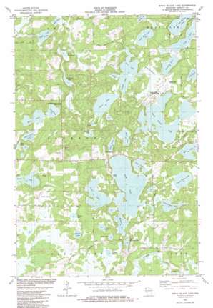
Birch Island Lake Topo Map Wisconsin
To zoom in, hover over the map of Birch Island Lake
USGS Topo Quad 45092h2 - 1:24,000 scale
| Topo Map Name: | Birch Island Lake |
| USGS Topo Quad ID: | 45092h2 |
| Print Size: | ca. 21 1/4" wide x 27" high |
| Southeast Coordinates: | 45.875° N latitude / 92.125° W longitude |
| Map Center Coordinates: | 45.9375° N latitude / 92.1875° W longitude |
| U.S. State: | WI |
| Filename: | o45092h2.jpg |
| Download Map JPG Image: | Birch Island Lake topo map 1:24,000 scale |
| Map Type: | Topographic |
| Topo Series: | 7.5´ |
| Map Scale: | 1:24,000 |
| Source of Map Images: | United States Geological Survey (USGS) |
| Alternate Map Versions: |
Birch Island Lake WI 1982, updated 1983 Download PDF Buy paper map Birch Island Lake WI 2010 Download PDF Buy paper map Birch Island Lake WI 2013 Download PDF Buy paper map Birch Island Lake WI 2015 Download PDF Buy paper map |
1:24,000 Topo Quads surrounding Birch Island Lake
> Back to 45092e1 at 1:100,000 scale
> Back to 45092a1 at 1:250,000 scale
> Back to U.S. Topo Maps home
Birch Island Lake topo map: Gazetteer
Birch Island Lake: Airports
Voyager Village Airstrip elevation 309m 1013′Birch Island Lake: Dams
Loon Lake 2WP344 Dam elevation 300m 984′Birch Island Lake: Lakes
Baker Lake elevation 299m 980′Bartash Lake elevation 300m 984′
Bass Lake elevation 299m 980′
Birch Island Lake elevation 300m 984′
Bogey Lake elevation 299m 980′
Boner Lake elevation 301m 987′
Cadotte Lake elevation 299m 980′
Coruick Lake elevation 299m 980′
Culbertson Lake elevation 293m 961′
Des Moines Lake elevation 299m 980′
Eagle Lake elevation 289m 948′
Green Lake elevation 300m 984′
Hanscom Lake elevation 300m 984′
Lang Lake elevation 297m 974′
Leaf Lake elevation 301m 987′
Little Bear Lake elevation 299m 980′
Little Mallard Lake elevation 298m 977′
Long Lake elevation 299m 980′
Lost Lake elevation 298m 977′
Lower Twin Lake elevation 300m 984′
Mallard Lake elevation 300m 984′
Mollete Lake elevation 299m 980′
Mud Lake elevation 290m 951′
Myre Lake elevation 298m 977′
North Lang Lake elevation 290m 951′
Oak Lake elevation 301m 987′
Phernetton Lake elevation 296m 971′
Pine Lake elevation 301m 987′
Point Lake elevation 299m 980′
Pratt Lake elevation 299m 980′
Round Lake elevation 297m 974′
Sand Lake elevation 300m 984′
Shoal Lake elevation 299m 980′
Swamp Lake elevation 298m 977′
Upper Twin Lake elevation 300m 984′
Birch Island Lake: Parks
Culbertson Springs State Fishery Area elevation 297m 974′Birch Island Lake: Reservoirs
Loon Lake elevation 299m 980′Birch Island Lake: Swamps
Kilkare Marsh elevation 301m 987′Birch Island Lake digital topo map on disk
Buy this Birch Island Lake topo map showing relief, roads, GPS coordinates and other geographical features, as a high-resolution digital map file on DVD:


