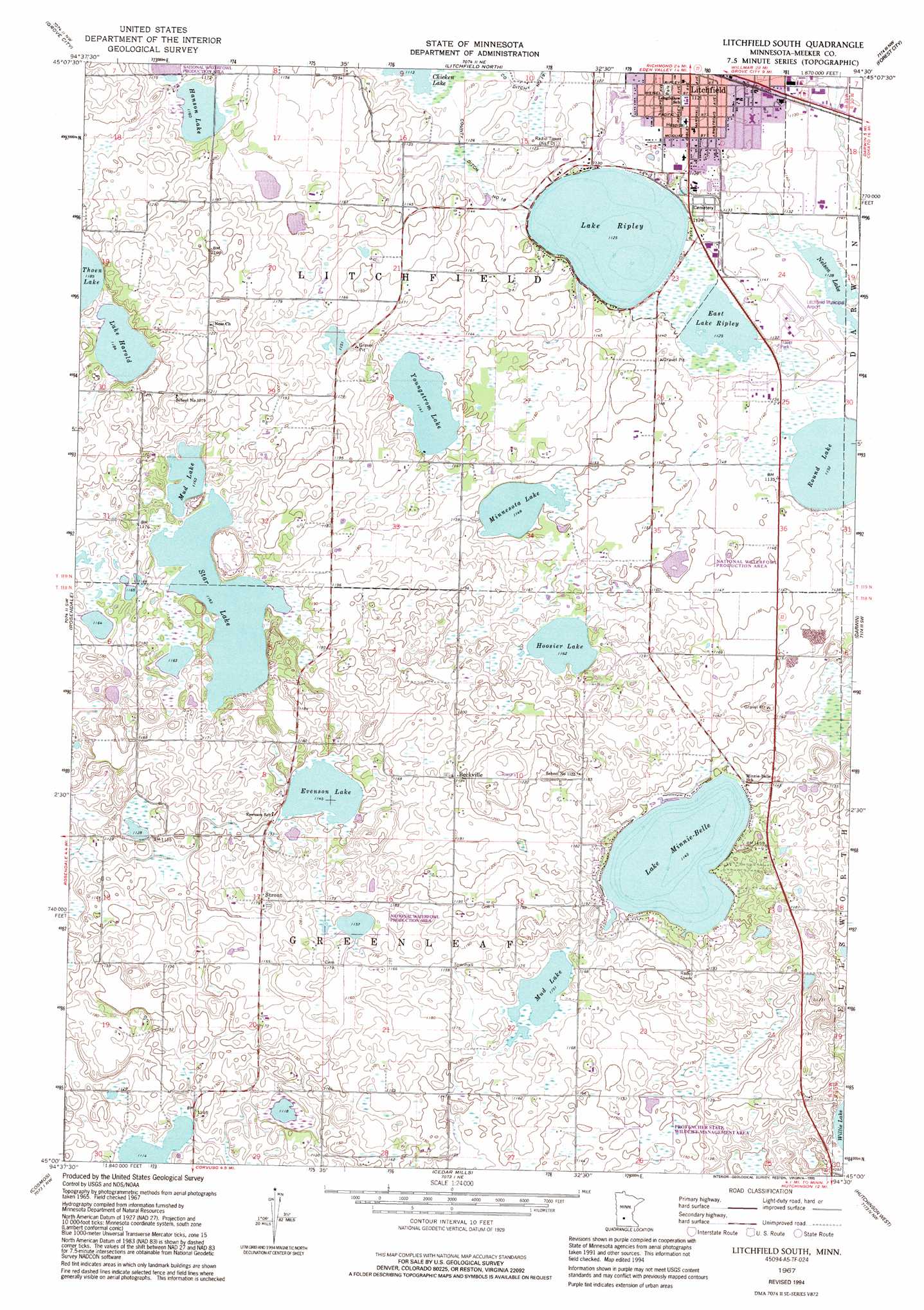
Litchfield South Topo Map Minnesota
To zoom in, hover over the map of Litchfield South
USGS Topo Quad 45094a5 - 1:24,000 scale
| Topo Map Name: | Litchfield South |
| USGS Topo Quad ID: | 45094a5 |
| Print Size: | ca. 21 1/4" wide x 27" high |
| Southeast Coordinates: | 45° N latitude / 94.5° W longitude |
| Map Center Coordinates: | 45.0625° N latitude / 94.5625° W longitude |
| U.S. State: | MN |
| Filename: | o45094a5.jpg |
| Download Map JPG Image: | Litchfield South topo map 1:24,000 scale |
| Map Type: | Topographic |
| Topo Series: | 7.5´ |
| Map Scale: | 1:24,000 |
| Source of Map Images: | United States Geological Survey (USGS) |
| Alternate Map Versions: |
Litchfield South MN 1967, updated 1968 Download PDF Buy paper map Litchfield South MN 1967, updated 1986 Download PDF Buy paper map Litchfield South MN 1967, updated 1995 Download PDF Buy paper map Litchfield South MN 2010 Download PDF Buy paper map Litchfield South MN 2013 Download PDF Buy paper map Litchfield South MN 2016 Download PDF Buy paper map |
1:24,000 Topo Quads surrounding Litchfield South
Hawick |
Lake Koronis |
Eden Valley |
Watkins |
Kimball |
Atwater |
Grove City |
Litchfield North |
Forest City |
Kingston |
Lake Elizabeth |
Rosendale |
Litchfield South |
Darwin |
Dassel |
Thorpe |
Cosmos |
Cedar Mills |
Hutchinson West |
Hutchinson East |
Olivia Se |
Churchill |
Lake Allie |
Heatwole |
Biscay |
> Back to 45094a1 at 1:100,000 scale
> Back to 45094a1 at 1:250,000 scale
> Back to U.S. Topo Maps home
Litchfield South topo map: Gazetteer
Litchfield South: Airports
L and M Aerodrome elevation 363m 1190′Litchfield Municipal Airport elevation 348m 1141′
Meeker County Memorial Hospital Heliport elevation 345m 1131′
Litchfield South: Canals
County Ditch Number Eighteen elevation 344m 1128′Litchfield South: Lakes
East Lake Ripley elevation 342m 1122′Evenson Lake elevation 348m 1141′
Hanson Lake elevation 354m 1161′
Hoosier Lake elevation 354m 1161′
Lake Andrew Nelson elevation 342m 1122′
Lake Harold elevation 360m 1181′
Lake Minnie-Belle elevation 348m 1141′
Lake Ripley elevation 342m 1122′
Minnesota Lake elevation 348m 1141′
Mud Lake elevation 351m 1151′
Mud Lake elevation 354m 1161′
Round Lake elevation 345m 1131′
Star Lake elevation 354m 1161′
Youngstrom Lake elevation 348m 1141′
Litchfield South: Parks
Anderson Gardens elevation 345m 1131′Anderson Gardens elevation 345m 1131′
Becker Park elevation 345m 1131′
Ladybird Park elevation 345m 1131′
Ladybird Park elevation 345m 1131′
Memorial Park elevation 345m 1131′
Memorial Park elevation 345m 1131′
Ness Lutheran Cemetery State Monument elevation 372m 1220′
Ness Lutheran Cemetery State Monument elevation 372m 1220′
Ness Lutheran Church and Ness Memorial Cemetery Historical Marker elevation 372m 1220′
Ness Lutheran Church and Ness Memorial Cemetery Historical Marker elevation 372m 1220′
Prairie Park elevation 347m 1138′
Prairie Park elevation 347m 1138′
Southside Park elevation 345m 1131′
Southside Park elevation 345m 1131′
Litchfield South: Populated Places
Beckville elevation 363m 1190′Evergreen Mobile Home Park elevation 345m 1131′
Evergreen Mobile Home Park elevation 345m 1131′
Litchfield Mobile Home Park elevation 345m 1131′
Litchfield Mobile Home Park elevation 345m 1131′
Strout elevation 359m 1177′
Litchfield South: Post Offices
Lake Harold Post Office (historical) elevation 366m 1200′Lake Harold Post Office (historical) elevation 366m 1200′
Strout Post Office (historical) elevation 359m 1177′
Strout Post Office (historical) elevation 359m 1177′
Litchfield South: Streams
Jewett Creek elevation 341m 1118′Litchfield South digital topo map on disk
Buy this Litchfield South topo map showing relief, roads, GPS coordinates and other geographical features, as a high-resolution digital map file on DVD: