Mill Point Topo Map Montana
To zoom in, hover over the map of Mill Point
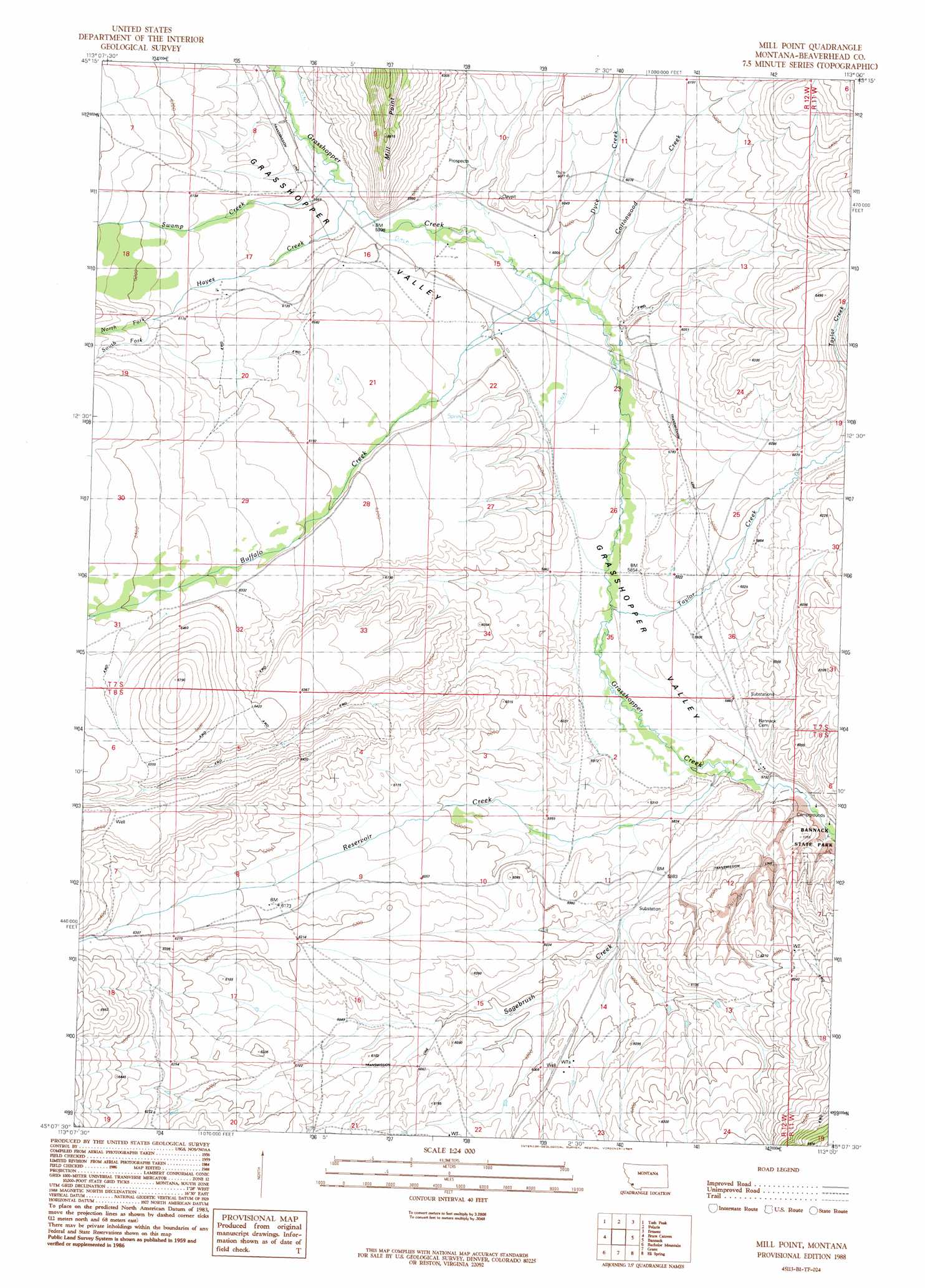
USGS Topo Quad 45113b1 - 1:24,000 scale
| Topo Map Name: | Mill Point |
| USGS Topo Quad ID: | 45113b1 |
| Print Size: | ca. 21 1/4" wide x 27" high |
| Southeast Coordinates: | 45.125° N latitude / 113° W longitude |
| Map Center Coordinates: | 45.1875° N latitude / 113.0625° W longitude |
| U.S. State: | MT |
| Filename: | o45113b1.jpg |
| Download Map JPG Image: | Mill Point topo map 1:24,000 scale |
| Map Type: | Topographic |
| Topo Series: | 7.5´ |
| Map Scale: | 1:24,000 |
| Source of Map Images: | United States Geological Survey (USGS) |
| Alternate Map Versions: |
Mill Point MT 1988, updated 1989 Download PDF Buy paper map Mill Point MT 1997, updated 2002 Download PDF Buy paper map Mill Point MT 2011 Download PDF Buy paper map Mill Point MT 2014 Download PDF Buy paper map |
| FStopo: | US Forest Service topo Mill Point is available: Download FStopo PDF Download FStopo TIF |
1:24,000 Topo Quads surrounding Mill Point
Jackson Hill |
Maverick Mountain |
Elkhorn Hot Springs |
Torrey Mountain |
Twin Adams Mountain |
Butch Hill |
Tash Peak |
Polaris |
Ermont |
Argenta |
Peterson Lake |
Brays Canyon |
Mill Point |
Bannack |
Burns Mountain |
Coyote Creek |
Bachelor Mountain |
Grant |
Eli Spring |
Dalys |
Everson Creek |
Jeff Davis Peak |
Hansen Ranch |
Garfield Canyon |
Red Rock |
> Back to 45113a1 at 1:100,000 scale
> Back to 45112a1 at 1:250,000 scale
> Back to U.S. Topo Maps home
Mill Point topo map: Gazetteer
Mill Point: Cliffs
Mill Point elevation 1954m 6410′Mill Point: Mines
Bannack State Park Mine elevation 1822m 5977′Hendricks/Apex Mill Site elevation 1912m 6272′
Placer Mines elevation 1801m 5908′
Mill Point: Streams
Buffalo Creek elevation 1810m 5938′Cottonwood Creek elevation 1810m 5938′
Dyce Creek elevation 1812m 5944′
Hayes Creek elevation 1824m 5984′
North Fork Hayes Creek elevation 1895m 6217′
Reservoir Creek elevation 1764m 5787′
Sagebrush Creek elevation 1762m 5780′
South Fork Hayes Creek elevation 1888m 6194′
Swamp Creek elevation 1823m 5980′
Taylor Creek elevation 1781m 5843′
Mill Point: Valleys
Grasshopper Valley elevation 1765m 5790′Mill Point: Wells
07S12W14CDDD01 Well elevation 1813m 5948′07S12W17CDBC01 Well elevation 1866m 6122′
07S12W22ABBB01 Well elevation 1827m 5994′
07S12W22ABCC01 Well elevation 1830m 6003′
07S12W22BAAD01 Well elevation 1831m 6007′
08S12W01DABC01 Well elevation 1769m 5803′
08S12W07ABBC01 Well elevation 2011m 6597′
08S12W23BBBA01 Well elevation 1840m 6036′
08S12W23BBBB01 Well elevation 1843m 6046′
08S39E14CBBD01 Well elevation 1820m 5971′
Mill Point digital topo map on disk
Buy this Mill Point topo map showing relief, roads, GPS coordinates and other geographical features, as a high-resolution digital map file on DVD: