Dalys Topo Map Montana
To zoom in, hover over the map of Dalys
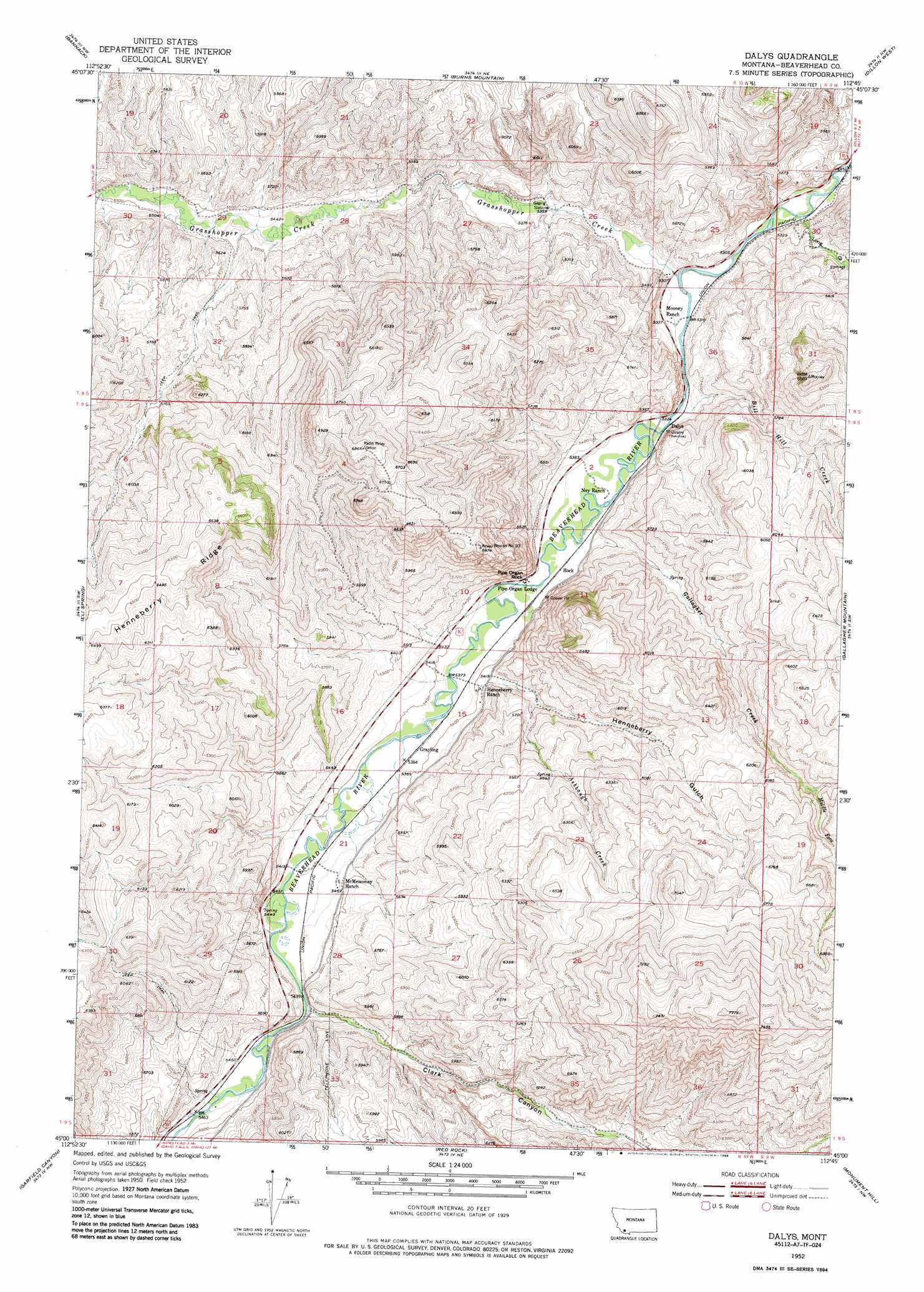
USGS Topo Quad 45112a7 - 1:24,000 scale
| Topo Map Name: | Dalys |
| USGS Topo Quad ID: | 45112a7 |
| Print Size: | ca. 21 1/4" wide x 27" high |
| Southeast Coordinates: | 45° N latitude / 112.75° W longitude |
| Map Center Coordinates: | 45.0625° N latitude / 112.8125° W longitude |
| U.S. State: | MT |
| Filename: | o45112a7.jpg |
| Download Map JPG Image: | Dalys topo map 1:24,000 scale |
| Map Type: | Topographic |
| Topo Series: | 7.5´ |
| Map Scale: | 1:24,000 |
| Source of Map Images: | United States Geological Survey (USGS) |
| Alternate Map Versions: |
Dalys MT 1952, updated 1954 Download PDF Buy paper map Dalys MT 1952, updated 1976 Download PDF Buy paper map Dalys MT 1952, updated 1986 Download PDF Buy paper map Dalys MT 2011 Download PDF Buy paper map Dalys MT 2014 Download PDF Buy paper map |
1:24,000 Topo Quads surrounding Dalys
Polaris |
Ermont |
Argenta |
Bond |
Glen Se |
Mill Point |
Bannack |
Burns Mountain |
Dillon West |
Dillon East |
Grant |
Eli Spring |
Dalys |
Gallagher Mountain |
Ashbough Canyon |
Hansen Ranch |
Garfield Canyon |
Red Rock |
Monument Hill |
Beech Creek |
Medicine Lodge Peak |
Deer Canyon |
Kidd |
Briggs Ranch |
Rock Island Ranch |
> Back to 45112a1 at 1:100,000 scale
> Back to 45112a1 at 1:250,000 scale
> Back to U.S. Topo Maps home
Dalys topo map: Gazetteer
Dalys: Bridges
Henneberry Bridge elevation 1638m 5374′Dalys: Dams
Clark Canyon Dam elevation 1665m 5462′Dalys: Pillars
Pipe Organ Rock elevation 1670m 5479′Dalys: Populated Places
Dalys elevation 1622m 5321′Grayling elevation 1643m 5390′
Dalys: Streams
Ashbaugh Creek elevation 1643m 5390′Bill Hill Creek elevation 1628m 5341′
Gallagher Creek elevation 1628m 5341′
Grasshopper Creek elevation 1616m 5301′
Middle Fork Gallagher Creek elevation 1847m 6059′
Dalys: Summits
Mooney Mountain elevation 2010m 6594′Dalys: Valleys
Clark Canyon elevation 1662m 5452′Henneberry Gulch elevation 1654m 5426′
Juniper Spring Gulch elevation 1665m 5462′
Long Gulch elevation 1615m 5298′
Dalys digital topo map on disk
Buy this Dalys topo map showing relief, roads, GPS coordinates and other geographical features, as a high-resolution digital map file on DVD: