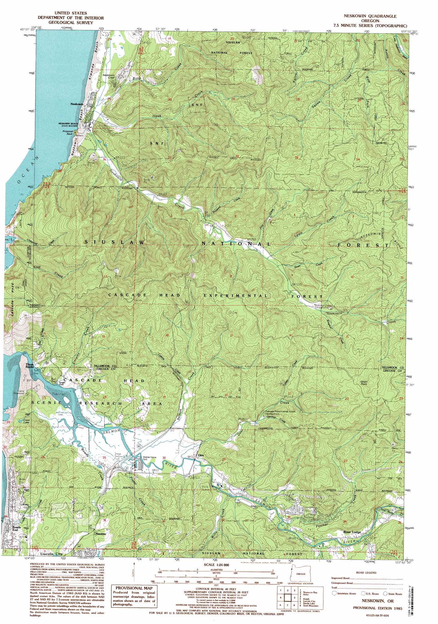
Neskowin Topo Map Oregon
To zoom in, hover over the map of Neskowin
USGS Topo Quad 45123a8 - 1:24,000 scale
| Topo Map Name: | Neskowin |
| USGS Topo Quad ID: | 45123a8 |
| Print Size: | ca. 21 1/4" wide x 27" high |
| Southeast Coordinates: | 45° N latitude / 123.875° W longitude |
| Map Center Coordinates: | 45.0625° N latitude / 123.9375° W longitude |
| U.S. State: | OR |
| Filename: | o45123a8.jpg |
| Download Map JPG Image: | Neskowin topo map 1:24,000 scale |
| Map Type: | Topographic |
| Topo Series: | 7.5´ |
| Map Scale: | 1:24,000 |
| Source of Map Images: | United States Geological Survey (USGS) |
| Alternate Map Versions: |
Neskowin OR 1985, updated 1985 Download PDF Buy paper map Neskowin OR 1985, updated 1995 Download PDF Buy paper map Neskowin OR 2011 Download PDF Buy paper map Neskowin OR 2014 Download PDF Buy paper map |
| FStopo: | US Forest Service topo Neskowin is available: Download FStopo PDF Download FStopo TIF |
1:24,000 Topo Quads surrounding Neskowin
Sand Lake |
Beaver |
Blaine |
||
Nestucca Bay |
Hebo |
Niagara Creek |
||
Neskowin |
Dolph |
Midway |
||
Lincoln City |
Devils Lake |
Stott Mountain |
Warnicke Creek |
|
Depoe Bay |
Mowrey Landing |
Euchre Mountain |
Valsetz |
> Back to 45123a1 at 1:100,000 scale
> Back to 45122a1 at 1:250,000 scale
> Back to U.S. Topo Maps home
Neskowin topo map: Gazetteer
Neskowin: Beaches
Neskowin Beach elevation 2m 6′Neskowin: Capes
Green Point elevation 394m 1292′Neskowin: Falls
Chitwood Falls elevation 223m 731′Neskowin: Forests
Cascade Head Experimental Forest elevation 262m 859′Neskowin: Islands
Proposal Rock elevation 0m 0′Neskowin: Lakes
Lake Neskowin elevation 7m 22′Neskowin: Parks
Cascade Head Scenic Research Area elevation 139m 456′Knight County Park elevation 3m 9′
Neskowin Beach State Recreation Site elevation 3m 9′
Neskowin Natural Area elevation 272m 892′
Neskowin: Populated Places
Neotsu elevation 21m 68′Neskowin elevation 4m 13′
Otis elevation 14m 45′
Rose Lodge elevation 55m 180′
Three Rocks elevation 3m 9′
Neskowin: Post Offices
Devils Lake Post Office (historical) elevation 7m 22′Emma Post Office (historical) elevation 116m 380′
Marx Post Office (historical) elevation 32m 104′
Neotsu Post Office elevation 21m 68′
Neskowin Post Office elevation 4m 13′
Otis Post Office elevation 14m 45′
Rose Lodge Post Office elevation 55m 180′
Yach Post Office (historical) elevation 41m 134′
Neskowin: Reservoirs
Deer Creek Lake elevation 82m 269′Neskowin: Streams
Baxter Creek elevation 2m 6′Bear Creek elevation 26m 85′
Butte Creek elevation 5m 16′
Calkins Creek elevation 37m 121′
Crowley Creek elevation 1m 3′
Curl Creek elevation 7m 22′
Deer Creek elevation 7m 22′
Fall Creek elevation 12m 39′
Fox Creek elevation 63m 206′
Frazer Creek elevation 0m 0′
Gardner Creek elevation 48m 157′
Hawk Creek elevation 5m 16′
Jim Creek elevation 56m 183′
Kingston Creek elevation 107m 351′
Kiwanda Creek elevation 3m 9′
Lewis Creek elevation 67m 219′
McMillin Creek elevation 30m 98′
Mink Creek elevation 0m 0′
Morton Creek elevation 25m 82′
Neskowin Creek elevation 4m 13′
North Fork Panther Creek elevation 65m 213′
Panther Creek elevation 10m 32′
Prospect Creek elevation 35m 114′
Rowdy Creek elevation 1m 3′
Salmon Creek elevation 16m 52′
Slick Rock Creek elevation 37m 121′
Sloan Creek elevation 76m 249′
Sutton Creek elevation 131m 429′
Telephone Creek elevation 40m 131′
Toketa Creek elevation 67m 219′
Tooze Creek elevation 24m 78′
West Fork Austin Creek elevation 74m 242′
Willis Creek elevation 8m 26′
Neskowin: Summits
Neskowin Crest elevation 59m 193′Neskowin digital topo map on disk
Buy this Neskowin topo map showing relief, roads, GPS coordinates and other geographical features, as a high-resolution digital map file on DVD: