Trout Brook Mountain Topo Map Maine
To zoom in, hover over the map of Trout Brook Mountain
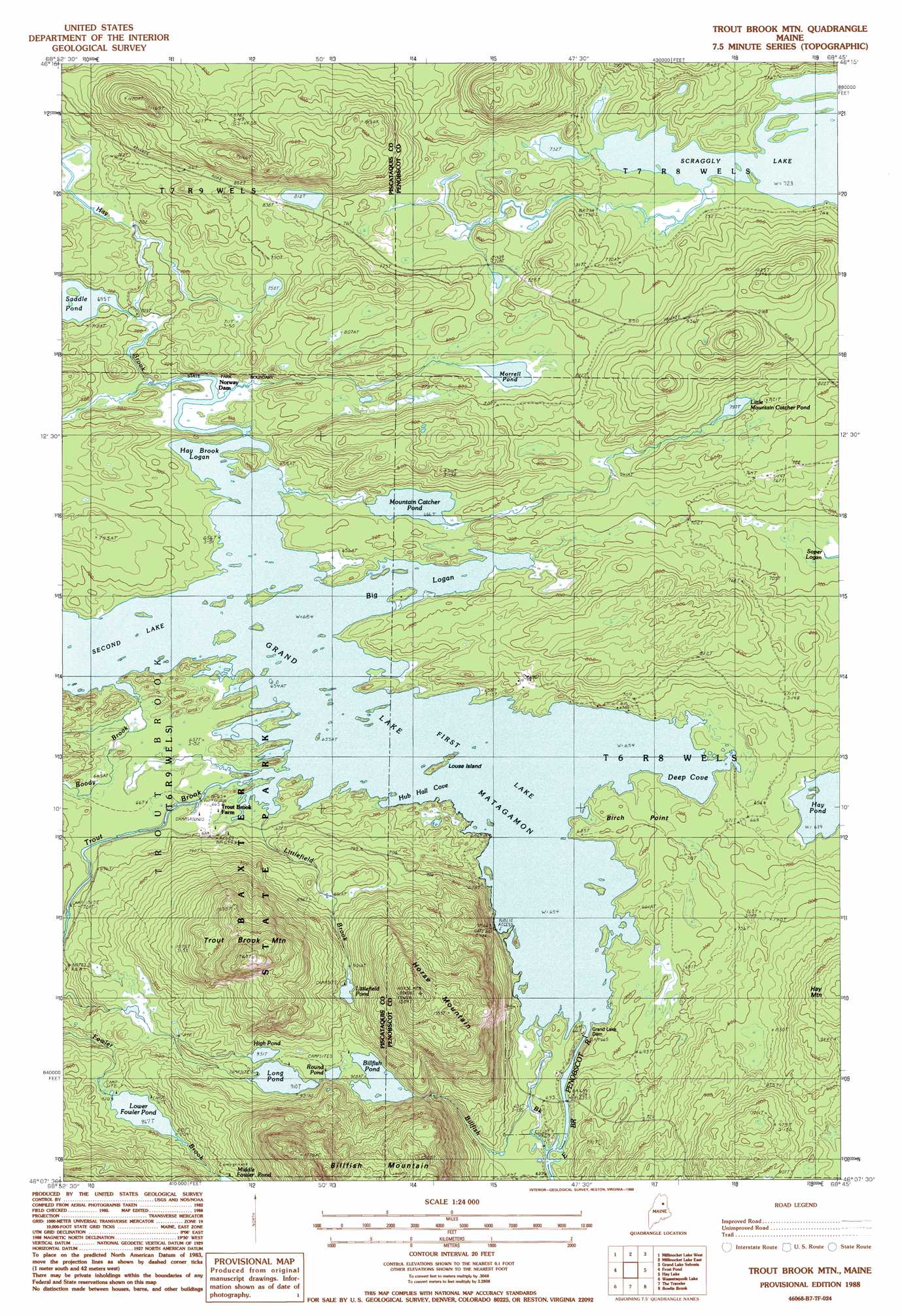
USGS Topo Quad 46068b7 - 1:24,000 scale
| Topo Map Name: | Trout Brook Mountain |
| USGS Topo Quad ID: | 46068b7 |
| Print Size: | ca. 21 1/4" wide x 27" high |
| Southeast Coordinates: | 46.125° N latitude / 68.75° W longitude |
| Map Center Coordinates: | 46.1875° N latitude / 68.8125° W longitude |
| U.S. State: | ME |
| Filename: | o46068b7.jpg |
| Download Map JPG Image: | Trout Brook Mountain topo map 1:24,000 scale |
| Map Type: | Topographic |
| Topo Series: | 7.5´ |
| Map Scale: | 1:24,000 |
| Source of Map Images: | United States Geological Survey (USGS) |
| Alternate Map Versions: |
Traveler Mountain NE ME 1975, updated 1981 Download PDF Buy paper map Trout Brook Mtn ME 1988, updated 1988 Download PDF Buy paper map Trout Brook Mtn ME 1988, updated 1988 Download PDF Buy paper map Trout Brook Mountain ME 2011 Download PDF Buy paper map Trout Brook Mountain ME 2014 Download PDF Buy paper map |
1:24,000 Topo Quads surrounding Trout Brook Mountain
Chase Lake |
Mooseleuk Mountain |
Middle Brook Mountain |
Chandler Mountain |
Oxbow West |
Beetle Mountain |
Millinocket Lake West |
Millinocket Lake East |
Grand Lake Seboeis |
La Pomkeag Lake |
Webster Lake |
Frost Pond |
Trout Brook Mountain |
Hay Lake |
Hay Brook Mountain |
Nesowad Nehunk Lake |
Wassataquoik Lake |
The Traveler |
Bowlin Brook |
Shin Pond |
Doubletop Mountain |
Mount Katahdin |
Katahdin Lake |
Deasey Mountain |
Lookout Mountain |
> Back to 46068a1 at 1:100,000 scale
> Back to 46068a1 at 1:250,000 scale
> Back to U.S. Topo Maps home
Trout Brook Mountain topo map: Gazetteer
Trout Brook Mountain: Bays
Big Logan elevation 199m 652′Deep Cove elevation 199m 652′
Hay Brook Logan elevation 200m 656′
Hub Hall Cove elevation 199m 652′
Trout Brook Mountain: Capes
Birch Point elevation 206m 675′Trout Brook Mountain: Dams
Grand Lake Dam elevation 199m 652′Norway Dam elevation 207m 679′
Trout Brook Mountain: Islands
Louse Island elevation 199m 652′Trout Brook Mountain: Lakes
Billfish Pond elevation 282m 925′First Lake elevation 199m 652′
Hay Pond elevation 194m 636′
High Pond elevation 277m 908′
Little Mountain Catcher Pond elevation 243m 797′
Littlefield Pond elevation 304m 997′
Long Pond elevation 277m 908′
Lower Fowler Pond elevation 264m 866′
Morrell Pond elevation 233m 764′
Mountain Catcher Pond elevation 203m 666′
Round Pond elevation 284m 931′
Scraggly Lake elevation 220m 721′
Trout Brook Mountain: Reservoirs
Grand Lake Matagamon elevation 199m 652′Trout Brook Mountain: Streams
Billfish Brook elevation 195m 639′Boody Brook elevation 226m 741′
Hay Brook elevation 207m 679′
Littlefield Brook elevation 200m 656′
Trout Brook elevation 199m 652′
Trout Brook Mountain: Summits
Horse Mountain elevation 465m 1525′Trout Brook Mountain elevation 501m 1643′
Trout Brook Mountain digital topo map on disk
Buy this Trout Brook Mountain topo map showing relief, roads, GPS coordinates and other geographical features, as a high-resolution digital map file on DVD:
Maine, New Hampshire, Rhode Island & Eastern Massachusetts
Buy digital topo maps: Maine, New Hampshire, Rhode Island & Eastern Massachusetts