Fort Simcoe Topo Map Washington
To zoom in, hover over the map of Fort Simcoe
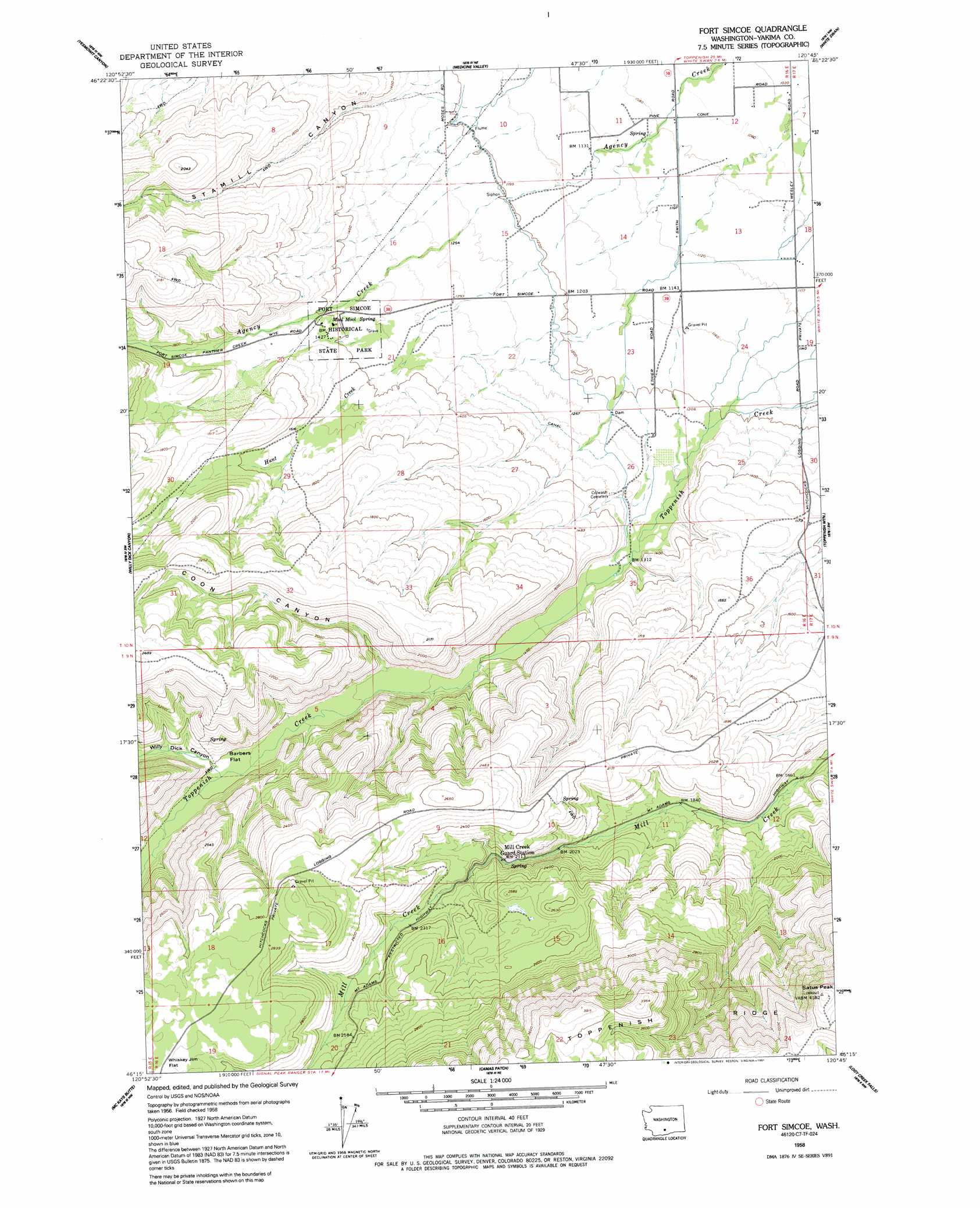
USGS Topo Quad 46120c7 - 1:24,000 scale
| Topo Map Name: | Fort Simcoe |
| USGS Topo Quad ID: | 46120c7 |
| Print Size: | ca. 21 1/4" wide x 27" high |
| Southeast Coordinates: | 46.25° N latitude / 120.75° W longitude |
| Map Center Coordinates: | 46.3125° N latitude / 120.8125° W longitude |
| U.S. State: | WA |
| Filename: | o46120c7.jpg |
| Download Map JPG Image: | Fort Simcoe topo map 1:24,000 scale |
| Map Type: | Topographic |
| Topo Series: | 7.5´ |
| Map Scale: | 1:24,000 |
| Source of Map Images: | United States Geological Survey (USGS) |
| Alternate Map Versions: |
Fort Simcoe WA 1958, updated 1960 Download PDF Buy paper map Fort Simcoe WA 1958, updated 1984 Download PDF Buy paper map Fort Simcoe WA 1958, updated 1991 Download PDF Buy paper map Fort Simcoe WA 2011 Download PDF Buy paper map Fort Simcoe WA 2013 Download PDF Buy paper map |
1:24,000 Topo Quads surrounding Fort Simcoe
Foundation Ridge |
Pine Mountain |
Tampico |
Wiley City |
Yakima West |
Piscoe Meadow |
Yesmowit Canyon |
Medicine Valley |
White Swan |
Harrah |
Lost Horse Plateau |
Willy Dick Canyon |
Fort Simcoe |
Toppenish Mountain |
Harrah Se |
Poland Butte |
Mckays Butte |
Camas Patch |
Logy Creek Falls |
Logy Creek Ne |
Twin Buttes |
Hagerty Butte |
Stagman Butte |
Logy Creek Sw |
Kusshi Creek |
> Back to 46120a1 at 1:100,000 scale
> Back to 46120a1 at 1:250,000 scale
> Back to U.S. Topo Maps home
Fort Simcoe topo map: Gazetteer
Fort Simcoe: Canals
Toppenish Lateral elevation 369m 1210′Fort Simcoe: Dams
White Swan Mill Ponds Dam elevation 314m 1030′Fort Simcoe: Flats
Barbers Flat elevation 487m 1597′Fort Simcoe: Parks
Fort Simcoe Historical State Park elevation 427m 1400′Fort Simcoe State Park elevation 427m 1400′
Fort Simcoe: Reservoirs
White Swan Mill Ponds elevation 314m 1030′Fort Simcoe: Springs
Mool Mool Spring elevation 429m 1407′Fort Simcoe: Streams
Hunt Creek elevation 368m 1207′Fort Simcoe: Summits
Satus Peak elevation 1273m 4176′Fort Simcoe: Valleys
Coon Canyon elevation 453m 1486′Stamill Canyon elevation 365m 1197′
Willy Dick Canyon elevation 488m 1601′
Fort Simcoe digital topo map on disk
Buy this Fort Simcoe topo map showing relief, roads, GPS coordinates and other geographical features, as a high-resolution digital map file on DVD: