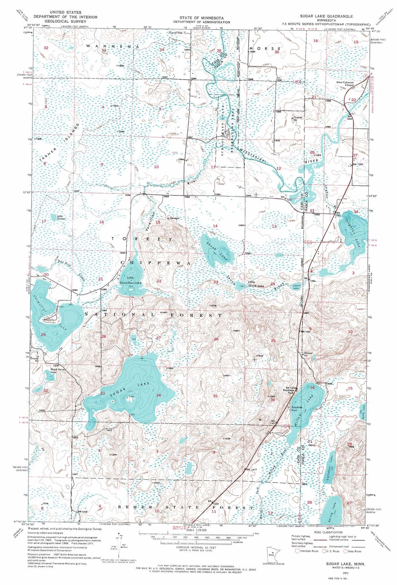
Sugar Lake Topo Map Minnesota
To zoom in, hover over the map of Sugar Lake
USGS Topo Quad 47093b7 - 1:24,000 scale
| Topo Map Name: | Sugar Lake |
| USGS Topo Quad ID: | 47093b7 |
| Print Size: | ca. 21 1/4" wide x 27" high |
| Southeast Coordinates: | 47.125° N latitude / 93.75° W longitude |
| Map Center Coordinates: | 47.1875° N latitude / 93.8125° W longitude |
| U.S. State: | MN |
| Filename: | o47093b7.jpg |
| Download Map JPG Image: | Sugar Lake topo map 1:24,000 scale |
| Map Type: | Topographic |
| Topo Series: | 7.5´ |
| Map Scale: | 1:24,000 |
| Source of Map Images: | United States Geological Survey (USGS) |
| Alternate Map Versions: |
Sugar Lake MN 1971, updated 1974 Download PDF Buy paper map Sugar Lake MN 1996, updated 1998 Download PDF Buy paper map Sugar Lake MN 2011 Download PDF Buy paper map Sugar Lake MN 2013 Download PDF Buy paper map Sugar Lake MN 2016 Download PDF Buy paper map |
| FStopo: | US Forest Service topo Sugar Lake is available: Download FStopo PDF Download FStopo TIF |
1:24,000 Topo Quads surrounding Sugar Lake
Little Winnibigoshish Lake |
Little Ball Club Lake |
Deer River Ne |
Little Bowstring Lake |
Wabana Lake |
Nushka Lake |
Ball Club |
Deer River |
Cohasset West |
Cohasset East |
Boy River |
Goose Lake |
Sugar Lake |
Siseebakwet Lake |
Grand Rapids |
Tobique |
Remer |
Shingle Mill Lake |
Big Thunder Peak |
Mountain Ash Lake |
Laura Lake |
Thunder Lake |
Shovel Lake |
Swatara |
Hill City |
> Back to 47093a1 at 1:100,000 scale
> Back to 47092a1 at 1:250,000 scale
> Back to U.S. Topo Maps home
Sugar Lake topo map: Gazetteer
Sugar Lake: Forests
Remer State Forest elevation 410m 1345′Sugar Lake: Islands
Tasher Islands elevation 398m 1305′Sugar Lake: Lakes
Callahan Lake elevation 425m 1394′Camel Lake elevation 389m 1276′
Dead Horse Lake elevation 395m 1295′
Lake Sixteen elevation 395m 1295′
Leighton Lake elevation 389m 1276′
Little Skunk Lake elevation 392m 1286′
Little Vermillion Lake elevation 390m 1279′
Skunk Lake elevation 392m 1286′
Spring Lake elevation 424m 1391′
Sugar Lake elevation 407m 1335′
Vermillion Lake elevation 390m 1279′
Willow Lake elevation 425m 1394′
Sugar Lake: Parks
School Craft State Recreation Area elevation 394m 1292′Schoolcraft State Recreation Area elevation 390m 1279′
Willow Lake Roadside Park elevation 433m 1420′
Sugar Lake: Streams
Dan Dick Creek elevation 390m 1279′Leighton Brook elevation 390m 1279′
Skunk Brook elevation 389m 1276′
Vermillion River elevation 390m 1279′
Sugar Lake: Trails
Sugar Lake Trail System elevation 422m 1384′Sugar Lake digital topo map on disk
Buy this Sugar Lake topo map showing relief, roads, GPS coordinates and other geographical features, as a high-resolution digital map file on DVD: