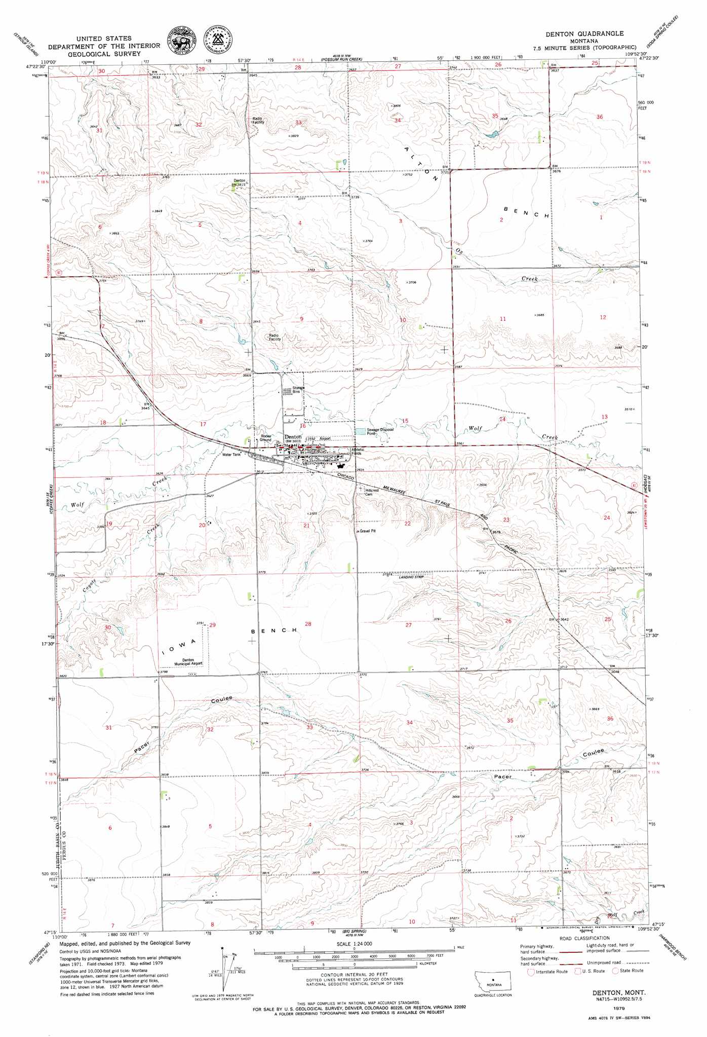
Denton Topo Map Montana
To zoom in, hover over the map of Denton
USGS Topo Quad 47109c8 - 1:24,000 scale
| Topo Map Name: | Denton |
| USGS Topo Quad ID: | 47109c8 |
| Print Size: | ca. 21 1/4" wide x 27" high |
| Southeast Coordinates: | 47.25° N latitude / 109.875° W longitude |
| Map Center Coordinates: | 47.3125° N latitude / 109.9375° W longitude |
| U.S. State: | MT |
| Filename: | o47109c8.jpg |
| Download Map JPG Image: | Denton topo map 1:24,000 scale |
| Map Type: | Topographic |
| Topo Series: | 7.5´ |
| Map Scale: | 1:24,000 |
| Source of Map Images: | United States Geological Survey (USGS) |
| Alternate Map Versions: |
Denton MT 1979, updated 1979 Download PDF Buy paper map Denton MT 2011 Download PDF Buy paper map Denton MT 2014 Download PDF Buy paper map |
1:24,000 Topo Quads surrounding Denton
Square Butte |
Square Butte Se |
Steele Lake Coulee |
Spring Coulee |
Wolf Creek Falls |
Pownal |
Strouf Island |
Possum Run Creek |
Soda Spring Coulee |
Wild Bill Flat West |
Arrow Creek |
Coffee Creek |
Denton |
Hoosac |
Toney Bench |
Stanford |
Stanford Ne |
Big Spring |
Harwood Bench |
Danvers |
Windham |
Benchland |
Moccasin |
Kolin |
Ross Fork |
> Back to 47109a1 at 1:100,000 scale
> Back to 47108a1 at 1:250,000 scale
> Back to U.S. Topo Maps home
Denton topo map: Gazetteer
Denton: Airports
Denton Airport elevation 1095m 3592′Denton: Benches
Iowa Bench elevation 1155m 3789′Denton: Dams
Tutsch Reservoir Dam elevation 1165m 3822′Denton: Parks
Denton City Park elevation 1098m 3602′Lions Club Park elevation 1097m 3599′
Denton: Populated Places
Denton elevation 1097m 3599′Denton: Post Offices
Denton Post Office elevation 1099m 3605′Denton: Streams
Coyote Creek elevation 1104m 3622′Denton: Wells
17N14E06DCCA02 Well elevation 1178m 3864′18N14E10DAB_01 Well elevation 1126m 3694′
18N14E14CAB_01 Well elevation 1082m 3549′
18N14E15DBB_01 Well elevation 1086m 3562′
18N14E30CDD_01 Well elevation 1163m 3815′
18N14E33AAA_01 Well elevation 1153m 3782′
19N14E28CCCB01 Well elevation 1105m 3625′
19N14E32AAB_01 Well elevation 1110m 3641′
19N14E33BBBB01 Well elevation 1120m 3674′
19N14E33BBBB02 Well elevation 1116m 3661′
19N14E33BBCD01 Well elevation 1124m 3687′
19N14E33BCBD01 Well elevation 1142m 3746′
Denton digital topo map on disk
Buy this Denton topo map showing relief, roads, GPS coordinates and other geographical features, as a high-resolution digital map file on DVD: