Wild Horse Island Topo Map Montana
To zoom in, hover over the map of Wild Horse Island
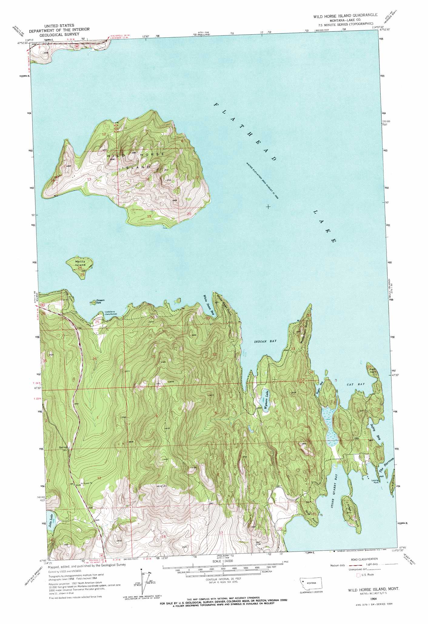
USGS Topo Quad 47114g2 - 1:24,000 scale
| Topo Map Name: | Wild Horse Island |
| USGS Topo Quad ID: | 47114g2 |
| Print Size: | ca. 21 1/4" wide x 27" high |
| Southeast Coordinates: | 47.75° N latitude / 114.125° W longitude |
| Map Center Coordinates: | 47.8125° N latitude / 114.1875° W longitude |
| U.S. State: | MT |
| Filename: | o47114g2.jpg |
| Download Map JPG Image: | Wild Horse Island topo map 1:24,000 scale |
| Map Type: | Topographic |
| Topo Series: | 7.5´ |
| Map Scale: | 1:24,000 |
| Source of Map Images: | United States Geological Survey (USGS) |
| Alternate Map Versions: |
Wild Horse Island MT 1964, updated 1966 Download PDF Buy paper map Wild Horse Island MT 2011 Download PDF Buy paper map Wild Horse Island MT 2014 Download PDF Buy paper map |
1:24,000 Topo Quads surrounding Wild Horse Island
Kila |
Lion Mountain |
Somers |
Bigfork |
Crater Lake |
Lake Mary Ronan |
Proctor |
Rollins |
Woods Bay |
Yew Creek |
Irvine Lookout Tower |
Elmo |
Wild Horse Island |
Bull Island |
Porcupine Creek |
Irvine Hill |
Buffalo Bridge |
Polson |
East Bay |
Cedar Lake |
Oliver Point |
Round Butte |
Lower Crow Reservoir |
Ronan |
Piper-Crow Pass |
> Back to 47114e1 at 1:100,000 scale
> Back to 47114a1 at 1:250,000 scale
> Back to U.S. Topo Maps home
Wild Horse Island topo map: Gazetteer
Wild Horse Island: Bays
Cat Bay elevation 883m 2896′Indian Bay elevation 883m 2896′
Safety Bay elevation 883m 2896′
Stone Quarry Bay elevation 883m 2896′
Taylor Bay elevation 883m 2896′
White Swan Bay elevation 883m 2896′
Wild Horse Island: Capes
Black Point elevation 905m 2969′Kings Point elevation 937m 3074′
Lansing Point elevation 883m 2896′
Lentz Point elevation 898m 2946′
Matterhorn Point elevation 955m 3133′
White Swan Point elevation 932m 3057′
Wolf Point elevation 892m 2926′
Wild Horse Island: Islands
Dream Island elevation 893m 2929′Little Bull Island elevation 903m 2962′
Melita Island elevation 895m 2936′
Wild Horse Island elevation 1065m 3494′
Wild Horse Island: Lakes
Wymore Lake elevation 883m 2896′Wild Horse Island: Parks
Flathead Lake State Park - Wild Horse Island Unit elevation 990m 3248′Wild Horse Island: Populated Places
Kings Point elevation 906m 2972′Lindisfarne elevation 889m 2916′
Wild Horse Island: Wells
23N20W04BBA_01 Well elevation 891m 2923′23N20W10DCDC01 Well elevation 936m 3070′
23N20W16BDCA01 Well elevation 900m 2952′
23N20W16CBC_01 Well elevation 959m 3146′
23N21W13BBD_01 Well elevation 1079m 3540′
24N19W22CBAA01 Well elevation 883m 2896′
24N21W25DDD_01 Well elevation 924m 3031′
24N21W36AAA_01 Well elevation 942m 3090′
24N21W36DBCA01 Well elevation 956m 3136′
Wild Horse Island digital topo map on disk
Buy this Wild Horse Island topo map showing relief, roads, GPS coordinates and other geographical features, as a high-resolution digital map file on DVD: