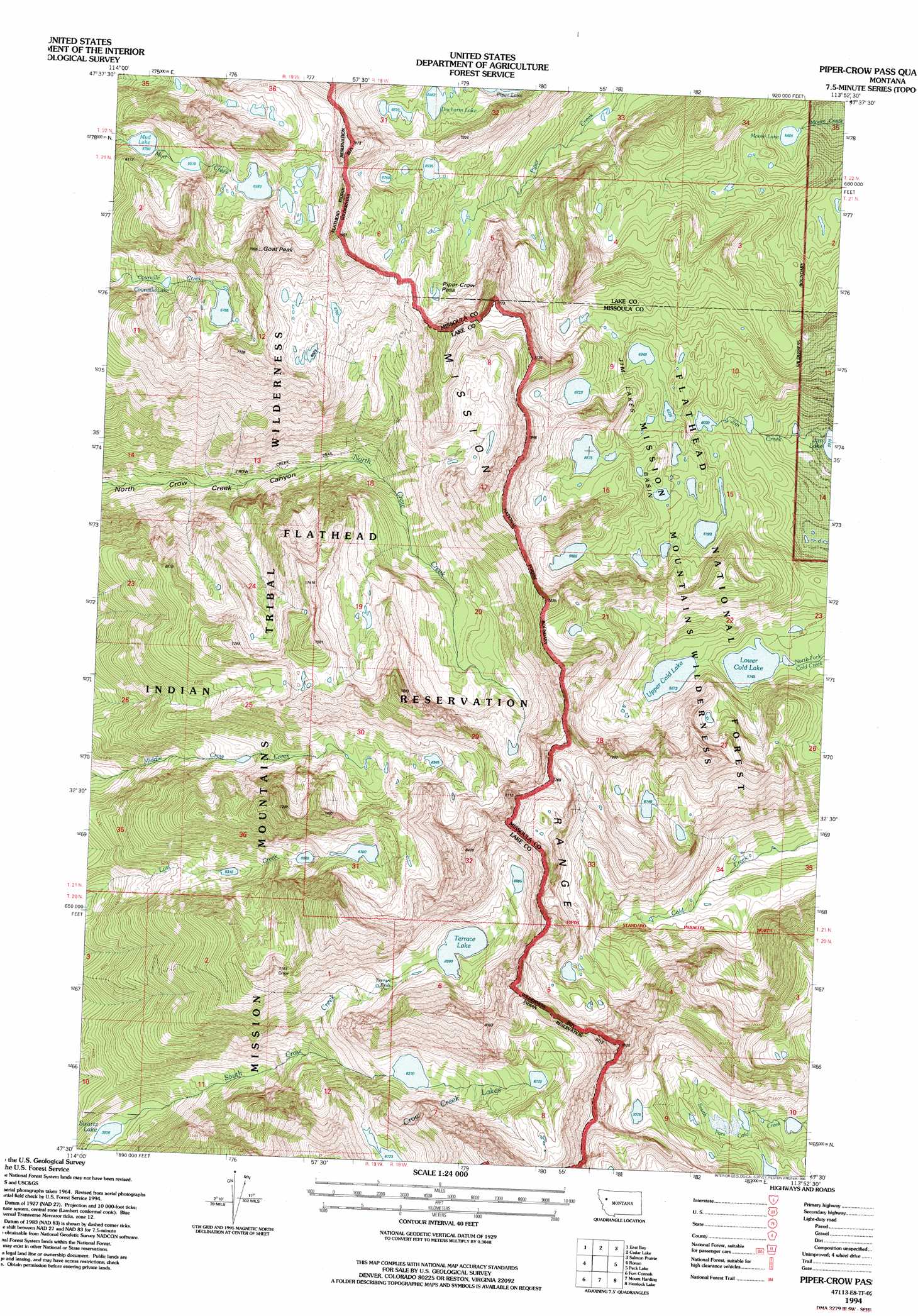
Piper-Crow Pass Topo Map Montana
To zoom in, hover over the map of Piper-Crow Pass
USGS Topo Quad 47113e8 - 1:24,000 scale
| Topo Map Name: | Piper-Crow Pass |
| USGS Topo Quad ID: | 47113e8 |
| Print Size: | ca. 21 1/4" wide x 27" high |
| Southeast Coordinates: | 47.5° N latitude / 113.875° W longitude |
| Map Center Coordinates: | 47.5625° N latitude / 113.9375° W longitude |
| U.S. State: | MT |
| Filename: | o47113e8.jpg |
| Download Map JPG Image: | Piper-Crow Pass topo map 1:24,000 scale |
| Map Type: | Topographic |
| Topo Series: | 7.5´ |
| Map Scale: | 1:24,000 |
| Source of Map Images: | United States Geological Survey (USGS) |
| Alternate Map Versions: |
Piper-Crow Pass MT 1965, updated 1968 Download PDF Buy paper map Piper-Crow Pass MT 1994, updated 1996 Download PDF Buy paper map Piper-Crow Pass MT 2011 Download PDF Buy paper map Piper-Crow Pass MT 2014 Download PDF Buy paper map |
| FStopo: | US Forest Service topo Piper-Crow Pass is available: Download FStopo PDF Download FStopo TIF |
1:24,000 Topo Quads surrounding Piper-Crow Pass
Wild Horse Island |
Bull Island |
Porcupine Creek |
Cilly Creek |
Thunderbolt Mountain |
Polson |
East Bay |
Cedar Lake |
Salmon Prairie |
Swan Peak |
Lower Crow Reservoir |
Ronan |
Piper-Crow Pass |
Peck Lake |
Condon |
Charlo |
Fort Connah |
Mount Harding |
Hemlock Lake |
Cygnet Lake |
Ravalli |
Saint Ignatius |
Saint Marys Lake |
Gray Wolf Lake |
Lake Marshall |
> Back to 47113e1 at 1:100,000 scale
> Back to 47112a1 at 1:250,000 scale
> Back to U.S. Topo Maps home
Piper-Crow Pass topo map: Gazetteer
Piper-Crow Pass: Basins
Jim Lakes Basin elevation 1978m 6489′Piper-Crow Pass: Falls
Terrace Falls elevation 1965m 6446′Piper-Crow Pass: Gaps
Piper-Crow Pass elevation 2090m 6856′Piper-Crow Pass: Lakes
Courville Lake elevation 1916m 6286′Crow Creek Lakes elevation 1912m 6272′
Ducharm Lake elevation 1971m 6466′
Jim Lake elevation 1682m 5518′
Lower Cold Lake elevation 1752m 5748′
Moore Lake elevation 1771m 5810′
Mud Lake elevation 1766m 5793′
Swartz Lake elevation 1198m 3930′
Terrace Lake elevation 2010m 6594′
Upper Cold Lake elevation 1791m 5875′
Piper-Crow Pass: Summits
Goat Peak elevation 2434m 7985′Piper-Crow Pass: Trails
Crow Creek Trail elevation 1463m 4799′Piper-Crow Pass digital topo map on disk
Buy this Piper-Crow Pass topo map showing relief, roads, GPS coordinates and other geographical features, as a high-resolution digital map file on DVD: