Benewah Lake Topo Map Idaho
To zoom in, hover over the map of Benewah Lake
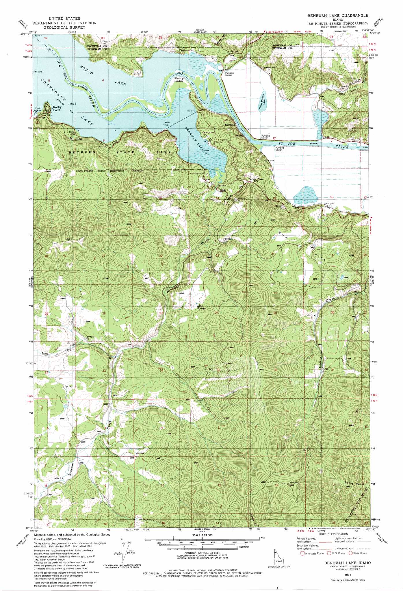
USGS Topo Quad 47116c6 - 1:24,000 scale
| Topo Map Name: | Benewah Lake |
| USGS Topo Quad ID: | 47116c6 |
| Print Size: | ca. 21 1/4" wide x 27" high |
| Southeast Coordinates: | 47.25° N latitude / 116.625° W longitude |
| Map Center Coordinates: | 47.3125° N latitude / 116.6875° W longitude |
| U.S. State: | ID |
| Filename: | o47116c6.jpg |
| Download Map JPG Image: | Benewah Lake topo map 1:24,000 scale |
| Map Type: | Topographic |
| Topo Series: | 7.5´ |
| Map Scale: | 1:24,000 |
| Source of Map Images: | United States Geological Survey (USGS) |
| Alternate Map Versions: |
Benewah Lake ID 1981, updated 1982 Download PDF Buy paper map Benewah Lake ID 2010 Download PDF Buy paper map Benewah Lake ID 2013 Download PDF Buy paper map |
1:24,000 Topo Quads surrounding Benewah Lake
Rockford Bay |
Mica Bay |
Mount Coeur D'Alene |
Lane |
Rose Lake |
Worley |
Harrison |
Black Lake |
Medimont |
Rochat Peak |
Plummer |
Chatcolet |
Benewah Lake |
Saint Maries |
Saint Joe Baldy |
Tensed |
Benewah |
Alder Creek Flats |
Lindstrom Peak |
Santa |
Mission Mountain |
Sanders |
West Dennis |
Emida |
Fernwood |
> Back to 47116a1 at 1:100,000 scale
> Back to 47116a1 at 1:250,000 scale
> Back to U.S. Topo Maps home
Benewah Lake topo map: Gazetteer
Benewah Lake: Airports
Sky Island Ranch Airport elevation 879m 2883′Benewah Lake: Bends
Hn'a'yqhn Bend elevation 741m 2431′Benewah Lake: Cliffs
Lotus Point elevation 1072m 3517′Benewah Lake: Gaps
Parker Pass elevation 758m 2486′Benewah Lake: Lakes
Benewah Lake elevation 649m 2129′Goose Heaven Lake elevation 650m 2132′
Hnchch'li Lake elevation 649m 2129′
Round Lake elevation 649m 2129′
Benewah Lake: Populated Places
Parkline elevation 672m 2204′Ramsdell elevation 687m 2253′
Rocky Point elevation 676m 2217′
Silvertip Landing elevation 650m 2132′
Benewah Lake: Springs
Echo Springs elevation 849m 2785′Benewah Lake: Streams
Benewah Creek elevation 652m 2139′Coon Creek elevation 781m 2562′
Deep Creek elevation 679m 2227′
Benewah Lake: Summits
Negro Brown Hill elevation 782m 2565′Shay Hill elevation 893m 2929′
Benewah Lake: Valleys
Hells Gulch elevation 653m 2142′Benewah Lake digital topo map on disk
Buy this Benewah Lake topo map showing relief, roads, GPS coordinates and other geographical features, as a high-resolution digital map file on DVD: