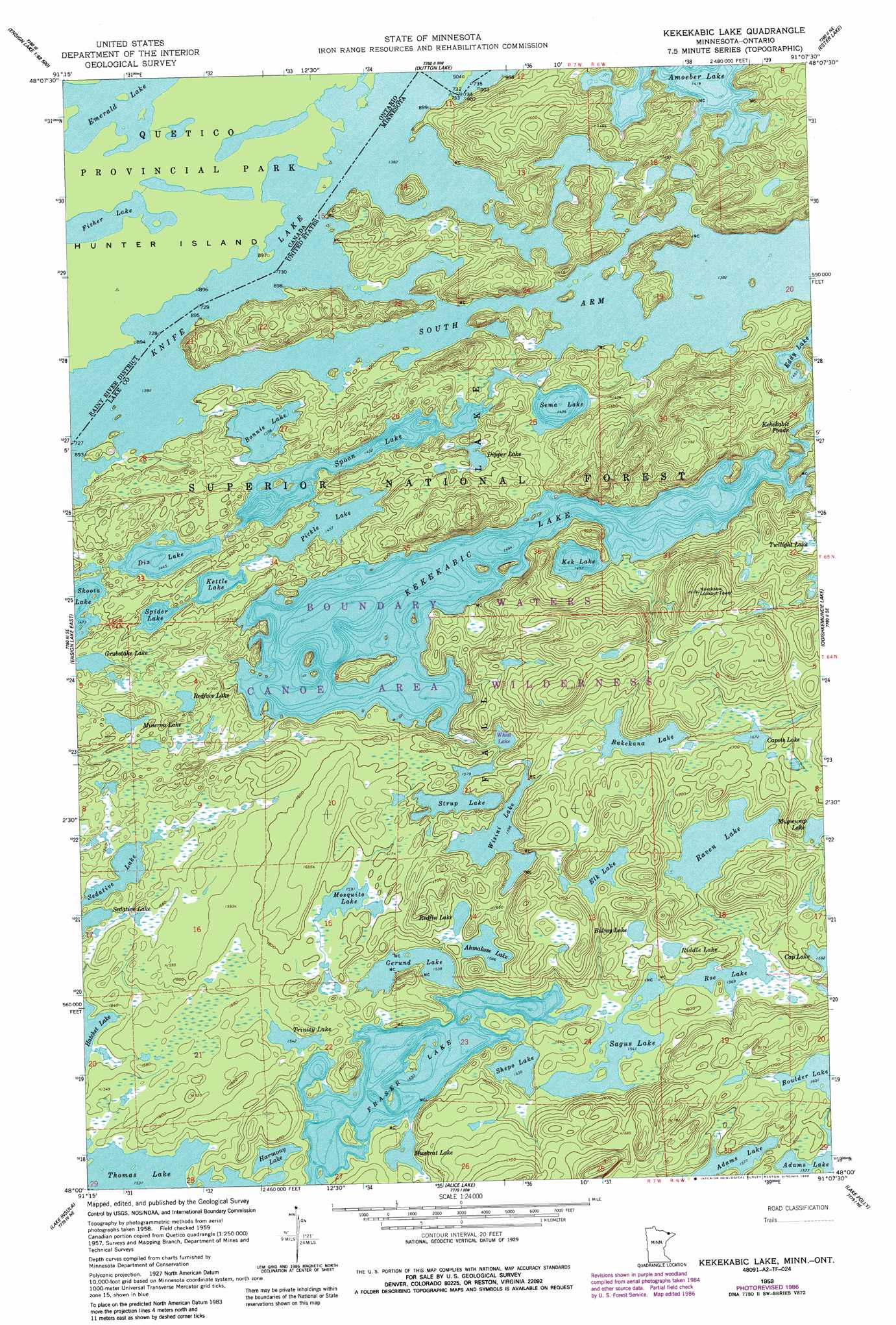
Kekekabic Lake Topo Map Minnesota
To zoom in, hover over the map of Kekekabic Lake
USGS Topo Quad 48091a2 - 1:24,000 scale
| Topo Map Name: | Kekekabic Lake |
| USGS Topo Quad ID: | 48091a2 |
| Print Size: | ca. 21 1/4" wide x 27" high |
| Southeast Coordinates: | 48° N latitude / 91.125° W longitude |
| Map Center Coordinates: | 48.0625° N latitude / 91.1875° W longitude |
| U.S. State: | MN |
| Filename: | o48091a2.jpg |
| Download Map JPG Image: | Kekekabic Lake topo map 1:24,000 scale |
| Map Type: | Topographic |
| Topo Series: | 7.5´ |
| Map Scale: | 1:24,000 |
| Source of Map Images: | United States Geological Survey (USGS) |
| Alternate Map Versions: |
Kekekabic Lake MN 1959, updated 1962 Download PDF Buy paper map Kekekabic Lake MN 1959, updated 1965 Download PDF Buy paper map Kekekabic Lake MN 1959, updated 1986 Download PDF Buy paper map Kekekabic Lake MN 2011 Download PDF Buy paper map Kekekabic Lake MN 2013 Download PDF Buy paper map Kekekabic Lake MN 2016 Download PDF Buy paper map |
| FStopo: | US Forest Service topo Kekekabic Lake is available: Download FStopo PDF Download FStopo TIF |
1:24,000 Topo Quads surrounding Kekekabic Lake
Dutton Lake |
Ester Lake |
Munker Island |
||
Ensign Lake West |
Ensign Lake East |
Kekekabic Lake |
Ogishkemuncie Lake |
Gillis Lake |
Snowbank Lake |
Lake Insula |
Alice Lake |
Lake Polly |
Kelso Mountain |
Quadga Lake |
Isabella Lake |
Perent Lake |
Kawishiwi Lake |
Beth Lake |
> Back to 48091a1 at 1:100,000 scale
> Back to 48090a1 at 1:250,000 scale
> Back to U.S. Topo Maps home
Kekekabic Lake topo map: Gazetteer
Kekekabic Lake: Lakes
Ahmakose Lake elevation 484m 1587′Amoeber Lake elevation 433m 1420′
Bakekana Lake elevation 497m 1630′
Balmy Lake elevation 491m 1610′
Bonnie Lake elevation 426m 1397′
Capote Lake elevation 510m 1673′
Dipper Lake elevation 450m 1476′
Dix Lake elevation 441m 1446′
Elk Lake elevation 505m 1656′
Fraser Lake elevation 467m 1532′
Gerund Lake elevation 469m 1538′
Grubstake Lake elevation 460m 1509′
Harmony Lake elevation 467m 1532′
Hatchet Lake elevation 460m 1509′
Kek Lake elevation 457m 1499′
Kekekabic Lake elevation 456m 1496′
Kettle Lake elevation 446m 1463′
Knife Lake elevation 421m 1381′
Minerva Lake elevation 485m 1591′
Mosquito Lake elevation 485m 1591′
Mugwump Lake elevation 515m 1689′
Muskrat Lake elevation 468m 1535′
Pickle Lake elevation 444m 1456′
Raven Lake elevation 491m 1610′
Redface Lake elevation 472m 1548′
Redfin Lake elevation 485m 1591′
Riddle Lake elevation 491m 1610′
Roe Lake elevation 478m 1568′
Sagus Lake elevation 470m 1541′
Sedative Lake elevation 460m 1509′
Sema Lake elevation 434m 1423′
Shepo Lake elevation 468m 1535′
Skoota Lake elevation 449m 1473′
South Arm Knife Lake elevation 421m 1381′
Spider Lake elevation 448m 1469′
Spoon Lake elevation 437m 1433′
Strup Lake elevation 482m 1581′
Trinity Lake elevation 470m 1541′
Whist Lake elevation 472m 1548′
Wisini Lake elevation 487m 1597′
Kekekabic Lake: Trails
Kekekabic Trail elevation 500m 1640′Kekekabic Lake digital topo map on disk
Buy this Kekekabic Lake topo map showing relief, roads, GPS coordinates and other geographical features, as a high-resolution digital map file on DVD: