Ensign Lake East Topo Map Minnesota
To zoom in, hover over the map of Ensign Lake East
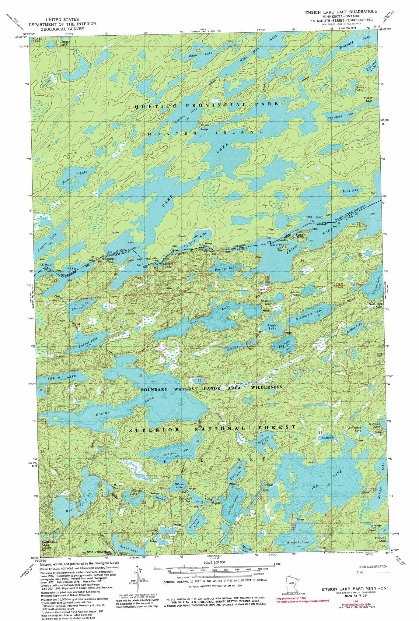
USGS Topo Quad 48091a3 - 1:24,000 scale
| Topo Map Name: | Ensign Lake East |
| USGS Topo Quad ID: | 48091a3 |
| Print Size: | ca. 21 1/4" wide x 27" high |
| Southeast Coordinates: | 48° N latitude / 91.25° W longitude |
| Map Center Coordinates: | 48.0625° N latitude / 91.3125° W longitude |
| U.S. State: | MN |
| Filename: | o48091a3.jpg |
| Download Map JPG Image: | Ensign Lake East topo map 1:24,000 scale |
| Map Type: | Topographic |
| Topo Series: | 7.5´ |
| Map Scale: | 1:24,000 |
| Source of Map Images: | United States Geological Survey (USGS) |
| Alternate Map Versions: |
Ensign Lake SE MN 1976, updated 1979 Download PDF Buy paper map Ensign Lake East MN 1981, updated 1981 Download PDF Buy paper map Ensign Lake East MN 1981, updated 1986 Download PDF Buy paper map Ensign Lake East MN 2011 Download PDF Buy paper map Ensign Lake East MN 2013 Download PDF Buy paper map Ensign Lake East MN 2016 Download PDF Buy paper map |
| FStopo: | US Forest Service topo Ensign Lake East is available: Download FStopo PDF Download FStopo TIF |
1:24,000 Topo Quads surrounding Ensign Lake East
Dutton Lake |
Ester Lake |
|||
Basswood Lake East |
Ensign Lake West |
Ensign Lake East |
Kekekabic Lake |
Ogishkemuncie Lake |
Ojibway Lake |
Snowbank Lake |
Lake Insula |
Alice Lake |
Lake Polly |
Gabbro Lake |
Quadga Lake |
Isabella Lake |
Perent Lake |
Kawishiwi Lake |
> Back to 48091a1 at 1:100,000 scale
> Back to 48090a1 at 1:250,000 scale
> Back to U.S. Topo Maps home
Ensign Lake East topo map: Gazetteer
Ensign Lake East: Islands
Isles of Pine elevation 422m 1384′Robbins Island elevation 425m 1394′
Ensign Lake East: Lakes
Abinodji Lake elevation 442m 1450′Adventure Lake elevation 453m 1486′
Ahsub Lake elevation 460m 1509′
Alworth Lake elevation 458m 1502′
Arkose Lake elevation 448m 1469′
Ashigan Lake elevation 433m 1420′
Bedford Lake elevation 454m 1489′
Boot Lake elevation 424m 1391′
Carp Lake elevation 449m 1473′
Cattyman Lake elevation 453m 1486′
Ensign Lake elevation 410m 1345′
Explorer Lake elevation 450m 1476′
Frog Lake elevation 426m 1397′
Gibson Lake elevation 442m 1450′
Haven Lake elevation 424m 1391′
Ima Lake elevation 458m 1502′
Jitterbug Lake elevation 454m 1489′
Jordan Lake elevation 454m 1489′
Melon Lake elevation 422m 1384′
Missionary Lake elevation 448m 1469′
Neglige Lake elevation 442m 1450′
Portage Lake elevation 424m 1391′
Reflection Lake elevation 460m 1509′
Seed Lake elevation 427m 1400′
Shallow Lake elevation 442m 1450′
Snatch Lake elevation 458m 1502′
Solitude Lake elevation 456m 1496′
Swing Lake elevation 450m 1476′
Three Eagle Lake elevation 454m 1489′
Trader Lake elevation 443m 1453′
Trident Lake elevation 414m 1358′
Vera Lake elevation 424m 1391′
Ensign Lake East: Streams
Knife River elevation 419m 1374′Ensign Lake East digital topo map on disk
Buy this Ensign Lake East topo map showing relief, roads, GPS coordinates and other geographical features, as a high-resolution digital map file on DVD: