Mountain View School Topo Map Montana
To zoom in, hover over the map of Mountain View School
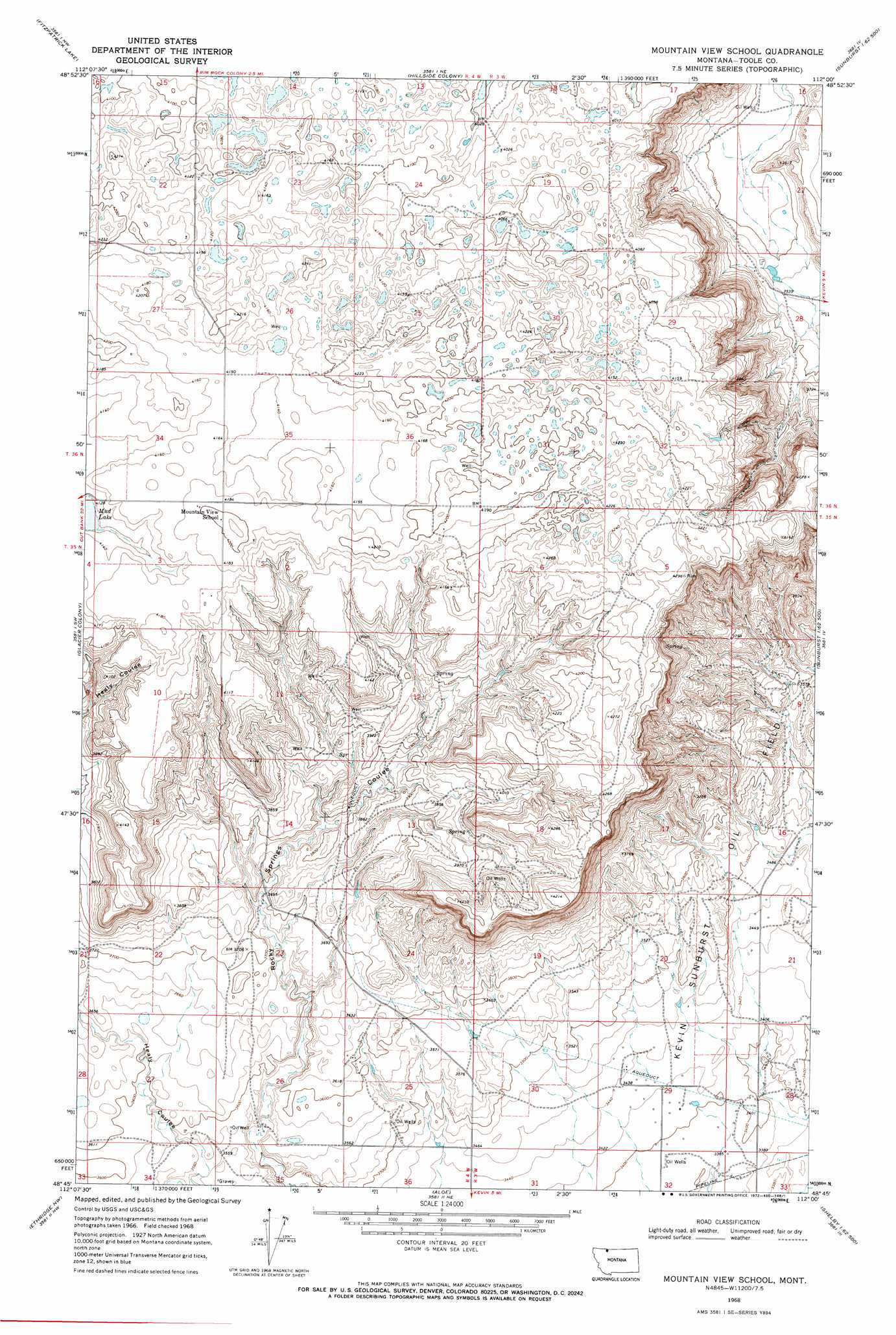
USGS Topo Quad 48112g1 - 1:24,000 scale
| Topo Map Name: | Mountain View School |
| USGS Topo Quad ID: | 48112g1 |
| Print Size: | ca. 21 1/4" wide x 27" high |
| Southeast Coordinates: | 48.75° N latitude / 112° W longitude |
| Map Center Coordinates: | 48.8125° N latitude / 112.0625° W longitude |
| U.S. State: | MT |
| Filename: | o48112g1.jpg |
| Download Map JPG Image: | Mountain View School topo map 1:24,000 scale |
| Map Type: | Topographic |
| Topo Series: | 7.5´ |
| Map Scale: | 1:24,000 |
| Source of Map Images: | United States Geological Survey (USGS) |
| Alternate Map Versions: |
Mountain View School MT 1968, updated 1972 Download PDF Buy paper map Mountain View School MT 2011 Download PDF Buy paper map Mountain View School MT 2014 Download PDF Buy paper map |
1:24,000 Topo Quads surrounding Mountain View School
Headlight Butte Ne |
Fitzpatrick Lake |
Hillside Colony |
Sunburst |
Willshaw Flats |
Headlight Butte |
Glacier Colony |
Mountain View School |
Kevin North |
Ferdig |
Cut Bank |
Ethridge Nw |
Aloe |
Kevin South |
Oilmont |
Cut Bank Se |
Boru Spring |
Ethridge |
Virden |
Shelby |
> Back to 48112e1 at 1:100,000 scale
> Back to 48112a1 at 1:250,000 scale
> Back to U.S. Topo Maps home
Mountain View School topo map: Gazetteer
Mountain View School: Lakes
Cowboys Lake elevation 1278m 4192′Foxtail Lakes elevation 1249m 4097′
Frenchman Lake elevation 1244m 4081′
Mud Lake elevation 1254m 4114′
Mountain View School: Oilfields
Kevin Sunburst Oil Field elevation 1076m 3530′Mountain View School: Wells
35N03W18CA__01 Well elevation 1240m 4068′35N04W01DB__01 Well elevation 1248m 4094′
35N04W02CA__01 Well elevation 1259m 4130′
35N04W03AA__01 Well elevation 1280m 4199′
35N04W03AA__02 Well elevation 1280m 4199′
35N04W11AA__01 Well elevation 1251m 4104′
35N04W11DC__01 Well elevation 1200m 3937′
35N04W11DC__02 Well elevation 1200m 3937′
35N04W11DD__01 Well elevation 1176m 3858′
35N04W12BB__01 Well elevation 1262m 4140′
35N04W12BC__01 Well elevation 1268m 4160′
35N04W12BD__01 Well elevation 1222m 4009′
35N04W12BD__02 Well elevation 1222m 4009′
35N04W12CA__01 Well elevation 1207m 3959′
35N04W12CB__01 Well elevation 1198m 3930′
35N04W12CB__02 Well elevation 1198m 3930′
36N03W19BB__01 Well elevation 1232m 4041′
36N03W19CC__01 Well elevation 1242m 4074′
36N03W30CB__01 Well elevation 1277m 4189′
36N03W30DD__01 Well elevation 1264m 4146′
36N03W32CD__01 Well elevation 1295m 4248′
36N04W22AD__01 Well elevation 1244m 4081′
36N04W22DC__01 Well elevation 1276m 4186′
36N04W25AB__01 Well elevation 1257m 4124′
36N04W34AD__01 Well elevation 1268m 4160′
36N04W35AA__01 Well elevation 1284m 4212′
36N04W35AB__01 Well elevation 1273m 4176′
36N04W35AD__01 Well elevation 1268m 4160′
36N04W35AD__02 Well elevation 1268m 4160′
36N04W36DA__01 Well elevation 1281m 4202′
Mountain View School digital topo map on disk
Buy this Mountain View School topo map showing relief, roads, GPS coordinates and other geographical features, as a high-resolution digital map file on DVD: