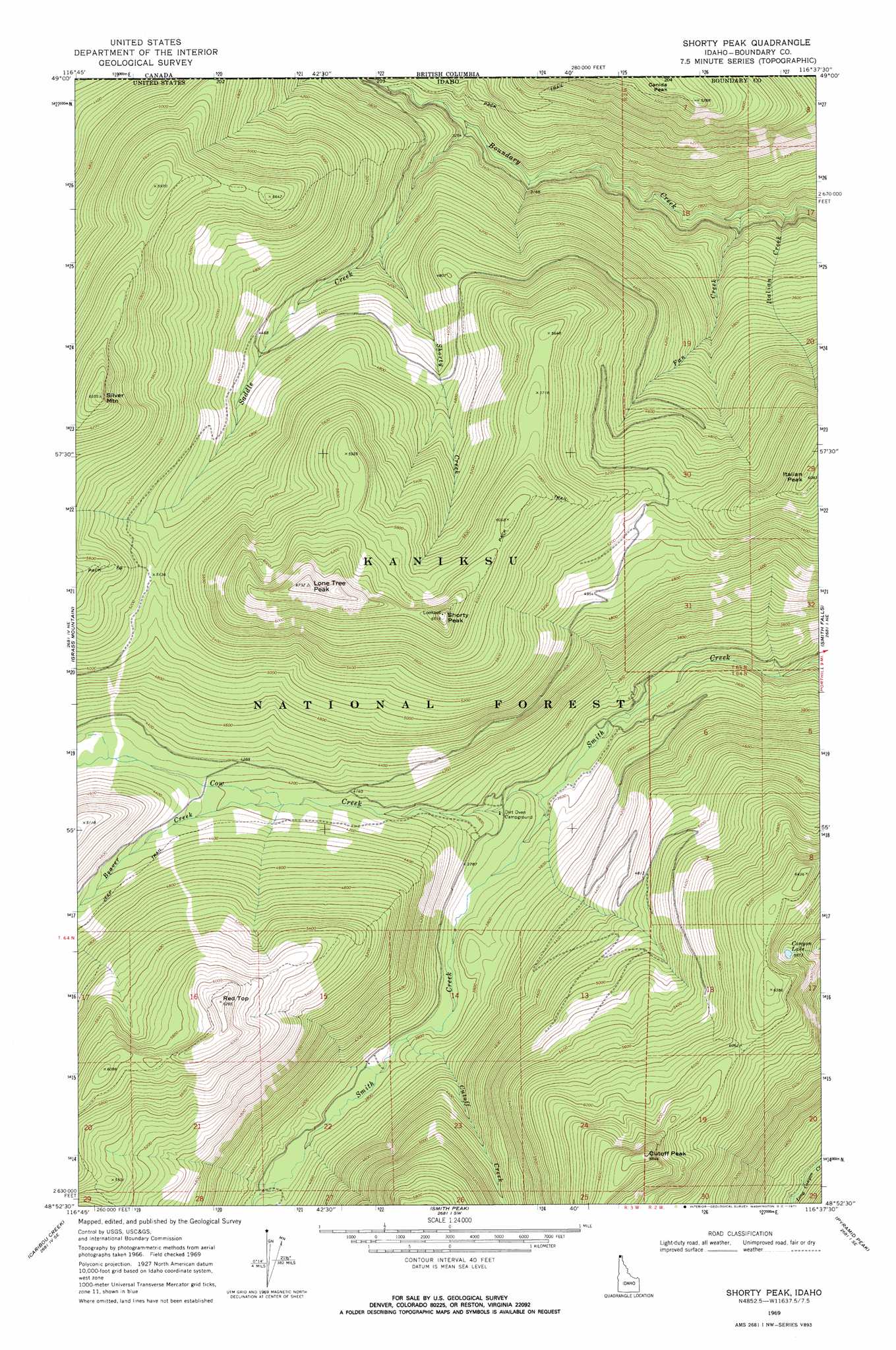
Shorty Peak Topo Map Idaho
To zoom in, hover over the map of Shorty Peak
USGS Topo Quad 48116h6 - 1:24,000 scale
| Topo Map Name: | Shorty Peak |
| USGS Topo Quad ID: | 48116h6 |
| Print Size: | ca. 21 1/4" wide x 27" high |
| Southeast Coordinates: | 48.875° N latitude / 116.625° W longitude |
| Map Center Coordinates: | 48.9375° N latitude / 116.6875° W longitude |
| U.S. State: | ID |
| Filename: | o48116h6.jpg |
| Download Map JPG Image: | Shorty Peak topo map 1:24,000 scale |
| Map Type: | Topographic |
| Topo Series: | 7.5´ |
| Map Scale: | 1:24,000 |
| Source of Map Images: | United States Geological Survey (USGS) |
| Alternate Map Versions: |
Shorty Peak ID 1969, updated 1971 Download PDF Buy paper map Shorty Peak ID 1996, updated 1999 Download PDF Buy paper map Shorty Peak ID 2011 Download PDF Buy paper map Shorty Peak ID 2013 Download PDF Buy paper map |
| FStopo: | US Forest Service topo Shorty Peak is available: Download FStopo PDF Download FStopo TIF |
1:24,000 Topo Quads surrounding Shorty Peak
Continental Mountain |
Grass Mountain |
Shorty Peak |
Smith Falls |
Copeland |
Upper Priest Lake |
Caribou Creek |
Smith Peak |
Pyramid Peak |
Farnham Peak |
Priest Lake Nw |
Priest Lake Ne |
The Wigwams |
Roman Nose |
Moravia |
> Back to 48116e1 at 1:100,000 scale
> Back to 48116a1 at 1:250,000 scale
> Back to U.S. Topo Maps home
Shorty Peak topo map: Gazetteer
Shorty Peak: Streams
Beaver Creek elevation 1261m 4137′Cow Creek elevation 1099m 3605′
Cutoff Creek elevation 1171m 3841′
Fan Creek elevation 800m 2624′
Italian Creek elevation 780m 2559′
Saddle Creek elevation 1006m 3300′
Shorty Creek elevation 1219m 3999′
Shorty Peak: Summits
Canida Peak elevation 1602m 5255′Cutoff Peak elevation 1892m 6207′
Italian Peak elevation 1848m 6062′
Lone Tree Peak elevation 2019m 6624′
Red Top elevation 1872m 6141′
Shorty Peak elevation 1879m 6164′
Silver Mountain elevation 1990m 6528′
Shorty Peak digital topo map on disk
Buy this Shorty Peak topo map showing relief, roads, GPS coordinates and other geographical features, as a high-resolution digital map file on DVD: