Republic Topo Map Washington
To zoom in, hover over the map of Republic
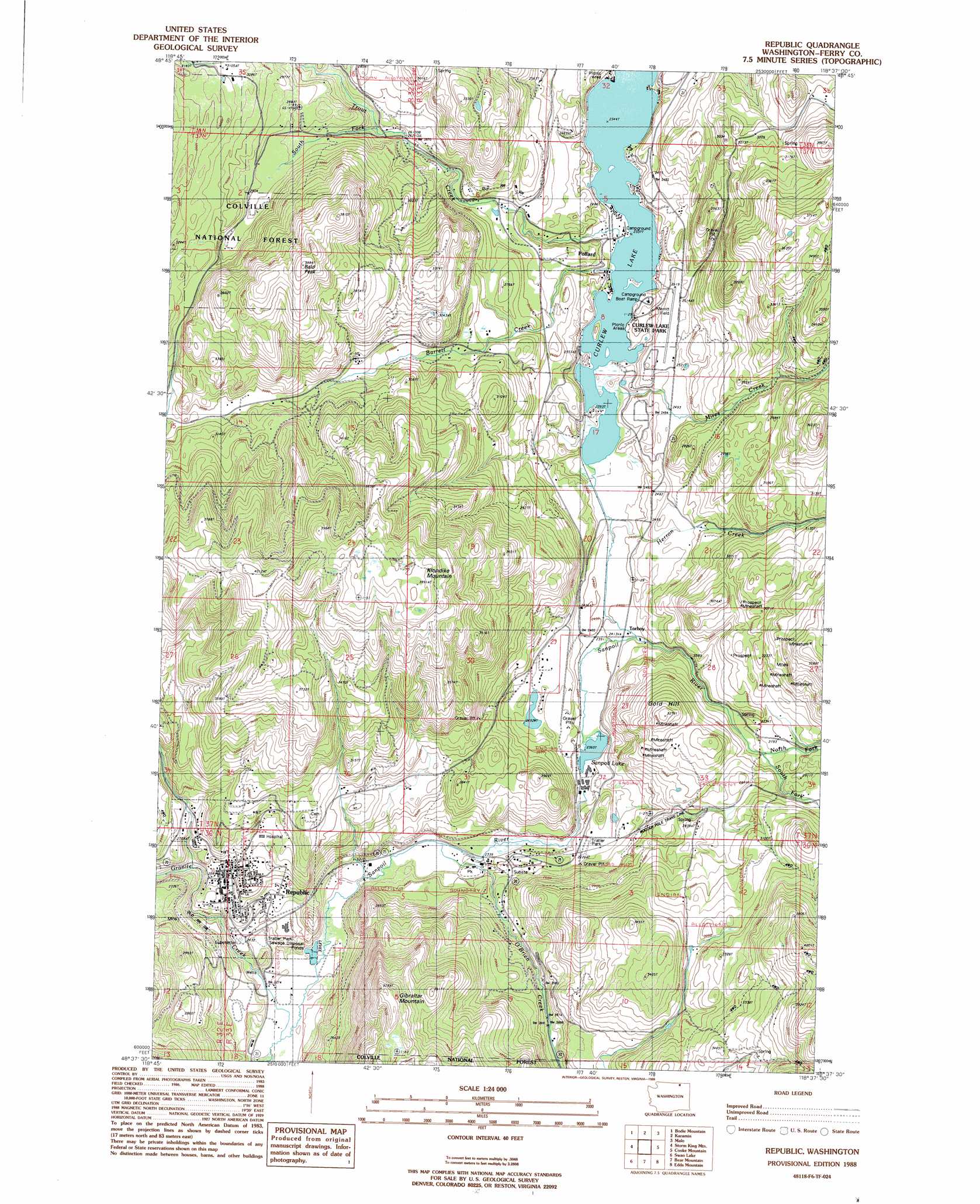
USGS Topo Quad 48118f6 - 1:24,000 scale
| Topo Map Name: | Republic |
| USGS Topo Quad ID: | 48118f6 |
| Print Size: | ca. 21 1/4" wide x 27" high |
| Southeast Coordinates: | 48.625° N latitude / 118.625° W longitude |
| Map Center Coordinates: | 48.6875° N latitude / 118.6875° W longitude |
| U.S. State: | WA |
| Filename: | o48118f6.jpg |
| Download Map JPG Image: | Republic topo map 1:24,000 scale |
| Map Type: | Topographic |
| Topo Series: | 7.5´ |
| Map Scale: | 1:24,000 |
| Source of Map Images: | United States Geological Survey (USGS) |
| Alternate Map Versions: |
Republic WA 1988, updated 1988 Download PDF Buy paper map Republic WA 1992, updated 1996 Download PDF Buy paper map Republic WA 2011 Download PDF Buy paper map Republic WA 2014 Download PDF Buy paper map |
| FStopo: | US Forest Service topo Republic is available: Download FStopo PDF Download FStopo TIF |
1:24,000 Topo Quads surrounding Republic
Buckhorn Mountain |
Toroda |
Vulcan Mountain |
Curlew |
Boundary Mountain |
Bodie |
Bodie Mountain |
Karamin |
Malo |
Mount Leona |
Wauconda Summit |
Storm King Mountain |
Republic |
Cooke Mountain |
Copper Butte |
Aeneas |
Swan Lake |
Bear Mountain |
Edds Mountain |
Sherman Peak |
Strawberry Mountain |
Bald Knob |
Thirteenmile Creek |
Seventeenmile Mountain |
Sitdown Mountain |
> Back to 48118e1 at 1:100,000 scale
> Back to 48118a1 at 1:250,000 scale
> Back to U.S. Topo Maps home
Republic topo map: Gazetteer
Republic: Airports
Fairweather Landing Area elevation 697m 2286′Ferry County Airport elevation 761m 2496′
Merritt Field elevation 766m 2513′
Perry County Memorial Hospital Heliport elevation 825m 2706′
Republic: Bays
Fishermans Cove elevation 718m 2355′Republic: Islands
Wiseman Island elevation 721m 2365′Zipphel Island elevation 718m 2355′
Republic: Lakes
Sanpoil Lake elevation 727m 2385′Republic: Parks
Curlew Lake State Park elevation 732m 2401′Republic: Populated Places
Pollard elevation 718m 2355′Republic elevation 783m 2568′
Torboy elevation 739m 2424′
Republic: Streams
Bacon Creek elevation 827m 2713′Barrett Creek elevation 718m 2355′
Granite Creek elevation 688m 2257′
Herron Creek elevation 718m 2355′
Mires Creek elevation 718m 2355′
North Fork Sanpoil River elevation 834m 2736′
O'Brien Creek elevation 705m 2312′
South Fork Sanpoil River elevation 834m 2736′
South Fork Trout Creek elevation 809m 2654′
Trout Creek elevation 718m 2355′
Republic: Summits
Bald Peak elevation 1185m 3887′Gibraltar Mountain elevation 1145m 3756′
Gold Hill elevation 993m 3257′
Klondike Mountain elevation 1221m 4005′
Republic digital topo map on disk
Buy this Republic topo map showing relief, roads, GPS coordinates and other geographical features, as a high-resolution digital map file on DVD: