Copper Butte Topo Map Washington
To zoom in, hover over the map of Copper Butte
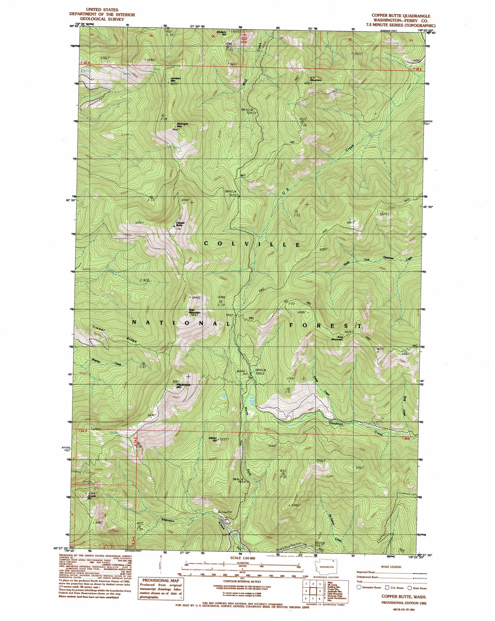
USGS Topo Quad 48118f4 - 1:24,000 scale
| Topo Map Name: | Copper Butte |
| USGS Topo Quad ID: | 48118f4 |
| Print Size: | ca. 21 1/4" wide x 27" high |
| Southeast Coordinates: | 48.625° N latitude / 118.375° W longitude |
| Map Center Coordinates: | 48.6875° N latitude / 118.4375° W longitude |
| U.S. State: | WA |
| Filename: | o48118f4.jpg |
| Download Map JPG Image: | Copper Butte topo map 1:24,000 scale |
| Map Type: | Topographic |
| Topo Series: | 7.5´ |
| Map Scale: | 1:24,000 |
| Source of Map Images: | United States Geological Survey (USGS) |
| Alternate Map Versions: |
Copper Butte WA 1985, updated 1985 Download PDF Buy paper map Copper Butte WA 1992, updated 1996 Download PDF Buy paper map Copper Butte WA 1992, updated 1996 Download PDF Buy paper map Copper Butte WA 2011 Download PDF Buy paper map Copper Butte WA 2014 Download PDF Buy paper map |
| FStopo: | US Forest Service topo Copper Butte is available: Download FStopo PDF Download FStopo TIF |
1:24,000 Topo Quads surrounding Copper Butte
Vulcan Mountain |
Curlew |
Boundary Mountain |
Independent Mountain |
Laurier |
Karamin |
Malo |
Mount Leona |
Bulldog Mountain |
Orient |
Republic |
Cooke Mountain |
Copper Butte |
Jackknife Mountain |
Boyds |
Bear Mountain |
Edds Mountain |
Sherman Peak |
South Huckleberry Mountain |
Bangs Mountain |
Thirteenmile Creek |
Seventeenmile Mountain |
Sitdown Mountain |
La Fleur Lake |
Rice |
> Back to 48118e1 at 1:100,000 scale
> Back to 48118a1 at 1:250,000 scale
> Back to U.S. Topo Maps home
Copper Butte topo map: Gazetteer
Copper Butte: Streams
Camp Creek elevation 1389m 4557′King Creek elevation 1268m 4160′
North Fork Sherman Creek elevation 1266m 4153′
Copper Butte: Summits
Albian Hill elevation 1739m 5705′Copper Butte elevation 2171m 7122′
Jungle Hill elevation 1984m 6509′
King Mountain elevation 2016m 6614′
Lambert Mountain elevation 1973m 6473′
Midnight Mountain elevation 2027m 6650′
Scar Mountain elevation 2141m 7024′
Stickpin Hill elevation 1733m 5685′
U S Mountain elevation 1886m 6187′
Wapaloosie Mountain elevation 2116m 6942′
Copper Butte digital topo map on disk
Buy this Copper Butte topo map showing relief, roads, GPS coordinates and other geographical features, as a high-resolution digital map file on DVD: