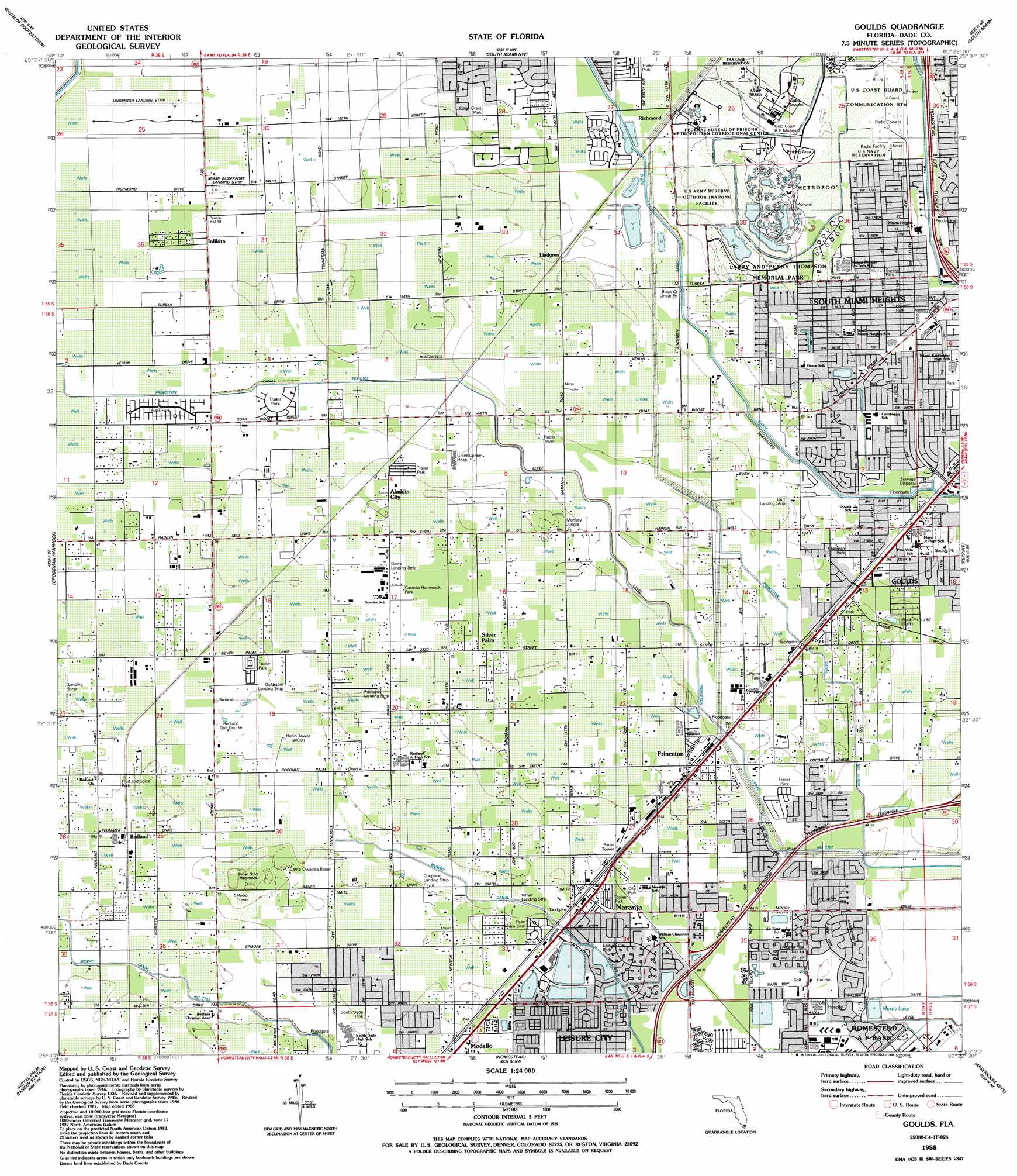
Goulds Topo Map Florida
To zoom in, hover over the map of Goulds
USGS Topo Quad 25080e4 - 1:24,000 scale
| Topo Map Name: | Goulds |
| USGS Topo Quad ID: | 25080e4 |
| Print Size: | ca. 21 1/4" wide x 27" high |
| Southeast Coordinates: | 25.5° N latitude / 80.375° W longitude |
| Map Center Coordinates: | 25.5625° N latitude / 80.4375° W longitude |
| U.S. State: | FL |
| Filename: | O25080E4.jpg |
| Download Map JPG Image: | Goulds topo map 1:24,000 scale |
| Map Type: | Topographic |
| Topo Series: | 7.5´ |
| Map Scale: | 1:24,000 |
| Source of Map Images: | United States Geological Survey (USGS) |
| Alternate Map Versions: |
Goulds FL 1949 Download PDF Buy paper map Goulds FL 1949 Download PDF Buy paper map Goulds FL 1956, updated 1957 Download PDF Buy paper map Goulds FL 1956, updated 1964 Download PDF Buy paper map Goulds FL 1956, updated 1970 Download PDF Buy paper map Goulds FL 1994, updated 1999 Download PDF Buy paper map Goulds FL 2012 Download PDF Buy paper map Goulds FL 2015 Download PDF Buy paper map |
1:24,000 Topo Quads surrounding Goulds
Long Island |
Coopertown |
Hialeah Sw |
Hialeah |
Miami |
Chekika Island |
South Of Coopertown |
South Miami Nw |
South Miami |
Key Biscayne |
Black Hammock |
Grossman Hammock |
Goulds |
Perrine |
Soldier Key |
Long Pine Key |
Royal Palm Ranger Station |
Homestead |
Arsenicker Keys |
Elliott Key |
Taylor Slough |
Royal Palm Ranger Station Se |
Glades |
Card Sound |
Pacific Reef |
> Back to 25080e1 at 1:100,000 scale
> Back to 25080a1 at 1:250,000 scale
> Back to U.S. Topo Maps home
Goulds topo map: Gazetteer
Goulds: Airports
B and L Farms Airport elevation 1m 3′Burrs Strip elevation 3m 9′
Coopland Landing Strip elevation 2m 6′
Davis Landing Strip elevation 3m 9′
Gouldstein Landing Strip elevation 3m 9′
Hugos Stolport elevation 3m 9′
Lindbergh Landing Strip elevation 2m 6′
Macs Field elevation 3m 9′
Miami Gliderport elevation 2m 6′
Miami Gliderport Landing Strip elevation 2m 6′
Redland Field elevation 3m 9′
Vihler Landing Strip elevation 2m 6′
Goulds: Canals
Black Creek Canal Number C-1 elevation 1m 3′Mowry Canal Number C-103 elevation 1m 3′
Princeton Canal Number C-102 elevation 3m 9′
Goulds: Islands
Bauer Drive Hammock elevation 4m 13′Goulds: Mines
Rock Pit Number 57 elevation 1m 3′Goulds: Parks
Black Creek Linear Park elevation 1m 3′Castello Hammock Park elevation 3m 9′
Eureka Park elevation 4m 13′
Goulds Park elevation 3m 9′
Goulds Wayside Park elevation 3m 9′
Kings Grant Park elevation 2m 6′
Larry and Penny Thompson Memorial Park elevation 3m 9′
Leisure City Park elevation 1m 3′
Metropolitan Zoo elevation 3m 9′
Monkey Jungle elevation 4m 13′
Naranja Park elevation 2m 6′
Orchard Jungle elevation 4m 13′
Preston B Bird-Mary Heinlein Fruit and Spice Park elevation 2m 6′
Sharman Park elevation 3m 9′
South Dade Park elevation 3m 9′
Goulds: Populated Places
Aladdin City elevation 3m 9′Dixie Trailer Park elevation 2m 6′
Goulds elevation 3m 9′
Inlikita elevation 2m 6′
Isla Gold Mobile Home Park elevation 2m 6′
Isla-Gold Mobile Home and Recreational Vehicle elevation 2m 6′
Leisure Mobile Home Park-Modello Park elevation 3m 9′
Leisure Mobile Park elevation 2m 6′
Lindgren elevation 3m 9′
Modello elevation 3m 9′
Naranja elevation 2m 6′
Palm Garden Manufactured Home Community elevation 3m 9′
Pine Isle Mobile Home Park elevation 2m 6′
Pine Isle Mobile Home Park elevation 2m 6′
Princeton elevation 3m 9′
Princetonian Mobile Home Park elevation 2m 6′
Princetonian Park elevation 2m 6′
Redland elevation 2m 6′
Redlands Mobile Home Park elevation 2m 6′
Royal Colonial Mobile elevation 2m 6′
Silver Palm elevation 3m 9′
Silver Palm Place elevation 2m 6′
Silver Palm Place Mobile Home Park elevation 2m 6′
South Miami Heights elevation 3m 9′
Sunrise Village Mobile Home Park elevation 2m 6′
Vehlin elevation 4m 13′
Goulds: Post Offices
Goulds Post Office elevation 3m 9′Princeton Post Office elevation 3m 9′
Goulds digital topo map on disk
Buy this Goulds topo map showing relief, roads, GPS coordinates and other geographical features, as a high-resolution digital map file on DVD: